File:Fiberline Bridge Kolding Denmark 2013c.JPG

Original file (3,838 × 2,720 pixels, file size: 4.03 MB, MIME type: image/jpeg)
Captions
Captions
Summary[edit]
| Description |
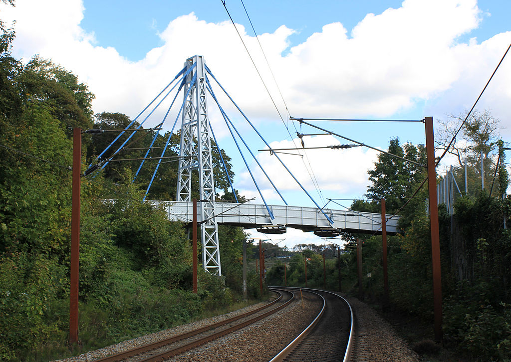
English: Fiber Line Bridge is one of the world's largest fiberglass composite bridges and the first to cross a railway line, which increases the requirements for the bridge. It is located in Kolding, Denmark.
The bridge was built in 1997 as a collaboration between the Municipality of Kolding, FiberLine Composites and Rambøll. It is Scandinavia's first composite bridge. The bridge weighs 12 tonnes, which is half of a bridge in metal / concrete. Another of the advantages of fiberglass composite is that it is almost maintenance-free. Since its construction in 1997, there have only been removed graffiti and algae. The bridge is also not affected by rain, frost and salt. Lifespan is at least 100 years. Technical data: Length, total 40 m Length, bridge section 1 27 m Length, bridge section 2 13 m Width, total 3.2 m Tower, height 18.5 m Total weight 12 tons Capacity 500 kg/m2 Capacity, running load 5 tons Maximum wheel pressure 1.8 tons The maximum deflection L/200 13 cm Number stag 8Dansk: Fiberline-broen er en af verdens største glasfiber-kompositbroer og den første der krydser en jernbanelinje, hvilket øger kravene til broen. Den ligger i Kolding, Danmark.
Broen blev opført i 1997, som et samarbejde mellem Kolding Kommune, Fiberline Composites og Rambøll. Det er Skandinaviens første kompositbro. Broen vejer kun 12 tons, hvilket er det halve af en bro i metal/beton. En anden af fordelene ved glasfiber-komposit er, at den er næsten vedligeholdelsesfri. Siden opførelsen i 1997, er der kun blevet fjernet graffiti og alger. Broen påvirkes heller ikke af regn,frost eller salt. levetid er mindst 100 år. Tekniske data: Længde, total 40 m Længde, brosektion 1. 27 m Længde, brosektion 2. 13 m Bredde, total 3,2 m Tårn, højde 18,5 m Totalvægt 12 tons Bæreevne 500 kg/m2 Bæreevne, kørende last 5 tons Maksimum hjultryk 1,8 tons Maksimum nedbøjning L/200 13 cm Antal stag 8 |
| Date | |
| Source | Own work |
| Author | S.Juhl |
| Camera location | | View this and other nearby images on: OpenStreetMap |
|---|
Licensing[edit]
| This file is made available under the Creative Commons CC0 1.0 Universal Public Domain Dedication. | |
| The person who associated a work with this deed has dedicated the work to the public domain by waiving all of their rights to the work worldwide under copyright law, including all related and neighboring rights, to the extent allowed by law. You can copy, modify, distribute and perform the work, even for commercial purposes, all without asking permission.
|
File history
Click on a date/time to view the file as it appeared at that time.
| Date/Time | Thumbnail | Dimensions | User | Comment | |
|---|---|---|---|---|---|
| current | 19:52, 28 September 2013 | | 3,838 × 2,720 (4.03 MB) | S.Juhl (talk | contribs) | User created page with UploadWizard |
You cannot overwrite this file.
File usage on Commons
The following page uses this file:
File usage on other wikis
The following other wikis use this file:
- Usage on da.wikipedia.org
- Usage on www.wikidata.org