File:Finland national road 92.png
Jump to navigation
Jump to search

Size of this preview: 341 × 600 pixels. Other resolutions: 136 × 240 pixels | 455 × 800 pixels.
Original file (455 × 800 pixels, file size: 135 KB, MIME type: image/png)
Captions
Captions
Add a one-line explanation of what this file represents
Summary[edit]
| Description |
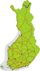
English: Map of the main road 92 in Finland, shown in dark blue. The other 1st class main roads (numbers 1–29) are red, 2nd class main roads (numbers 40–98) yellow. Black dots show the 12 biggest urban areas.
Suomi: Kantatie 92 on merkitty karttaan tummansinisellä. Muut valtatiet (numerot 1–29) on merkitty karttaan punaisella, kantatiet (numerot 40–98) keltaisella. Tärkeimmät kaupunkiseudut on merkitty mustilla pisteillä. |
| Date | |
| Source | Own work |
| Author | Migro |
Licensing[edit]
| I, the copyright holder of this work, release this work into the public domain. This applies worldwide. In some countries this may not be legally possible; if so: I grant anyone the right to use this work for any purpose, without any conditions, unless such conditions are required by law. |
File history
Click on a date/time to view the file as it appeared at that time.
| Date/Time | Thumbnail | Dimensions | User | Comment | |
|---|---|---|---|---|---|
| current | 17:15, 2 November 2018 | | 455 × 800 (135 KB) | BIL (talk | contribs) | Added Kaamanen–Näätämö which was added to the road number in 2016 |
| 16:32, 2 July 2007 |  | 455 × 800 (109 KB) | Migro (talk | contribs) | == Summary == {{Information |Description=Map of main road 92 in Finland, shown in dark blue. Roads number 1-29 are red, 40-98 yellow. Black dots show the 12 biggest urban areas. |Source=self-made |Date=2007-07-02 |Author= Migro }} [[Categ |
You cannot overwrite this file.
File usage on Commons
The following 6 pages use this file:
- User:Apalsola/recent uploads/Lapland, Finland/2018 November 1-10
- User:Apalsola/recent uploads/Roads in Finland/2018 November 1-10
- User:Chumwa/OgreBot/Potential transport maps/2018 November 1-10
- User:Chumwa/OgreBot/Transport Maps/2018 November 1-10
- User:Chumwa/OgreBot/Travel and communication maps/2018 November 1-10
- Category:National road 92 (Finland)
File usage on other wikis
The following other wikis use this file:
- Usage on fr.wikipedia.org
- Usage on it.wikipedia.org
- Usage on no.wikipedia.org
- Usage on sv.wikipedia.org
- Usage on www.wikidata.org