File:Footpath Beside the North Circular Road - geograph.org.uk - 1122441.jpg
Jump to navigation
Jump to search

Size of this preview: 390 × 599 pixels. Other resolutions: 156 × 240 pixels | 417 × 640 pixels.
Original file (417 × 640 pixels, file size: 171 KB, MIME type: image/jpeg)
Captions
Captions
Add a one-line explanation of what this file represents
Summary[edit]
| Description |
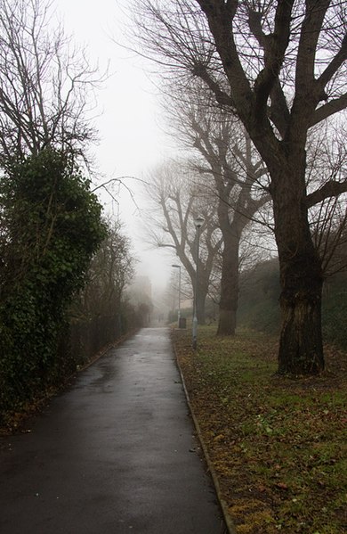
English: Footpath Beside the North Circular Road This footpath and the line of trees is the remnants of the North Circular as it was in the vicinity of Long Lane. The Road was originally at the same height as this path and had a traffic light controlled level junction with Long Lane just beyond the bollards that are visible in the distance. The North Circular is now significantly higher as it crosses Long Lane on bridge - The embankment on the right gives an indication of how much higher. Long Lane itself was lowered to give sufficient clearance for lorries and the fire engines from Finchley Fire Station to pass under the bridge. Just visible through the mist in the distance is the ramp up to the bus stop on the eastbound carriageway of the North Circular from Long Lane. |
| Date | |
| Source | From geograph.org.uk |
| Author | Martin Addison |
| Attribution (required by the license) | Martin Addison / Footpath Beside the North Circular Road / |
| Camera location | | View this and other nearby images on: OpenStreetMap |
|---|
_heading:45.00&language=en)
| Object location | | View this and other nearby images on: OpenStreetMap |
|---|
_heading:45.00&language=en)
Licensing[edit]

|
This image was taken from the Geograph project collection. See this photograph's page on the Geograph website for the photographer's contact details. The copyright on this image is owned by Martin Addison and is licensed for reuse under the Creative Commons Attribution-ShareAlike 2.0 license.
|
This file is licensed under the Creative Commons Attribution-Share Alike 2.0 Generic license.
Attribution: Martin Addison
- You are free:
- to share – to copy, distribute and transmit the work
- to remix – to adapt the work
- Under the following conditions:
- attribution – You must give appropriate credit, provide a link to the license, and indicate if changes were made. You may do so in any reasonable manner, but not in any way that suggests the licensor endorses you or your use.
- share alike – If you remix, transform, or build upon the material, you must distribute your contributions under the same or compatible license as the original.
File history
Click on a date/time to view the file as it appeared at that time.
| Date/Time | Thumbnail | Dimensions | User | Comment | |
|---|---|---|---|---|---|
| current | 00:28, 25 February 2011 | | 417 × 640 (171 KB) | GeographBot (talk | contribs) | == {{int:filedesc}} == {{Information |description={{en|1=Footpath Beside the North Circular Road This footpath and the line of trees is the remnants of the North Circular as it was in the vicinity of Long Lane. The Road was originally at the same height |
You cannot overwrite this file.
File usage on Commons
There are no pages that use this file.