File:Former Cleator & Workington Junction Railway at Harrington Junction, 1951 (geograph 5162661).jpg
Jump to navigation
Jump to search

Size of this preview: 800 × 469 pixels. Other resolutions: 320 × 187 pixels | 640 × 375 pixels | 1,024 × 600 pixels | 1,280 × 750 pixels | 2,342 × 1,372 pixels.
Original file (2,342 × 1,372 pixels, file size: 1.22 MB, MIME type: image/jpeg)
Captions
Captions
Add a one-line explanation of what this file represents
Summary[edit]
.jpg&action=edit§ion=1)
| Description |
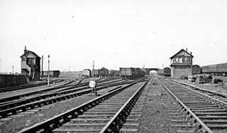
English: Former Cleator & Workington Junction Railway at Harrington Junction, 1951 This is a puzzling photograph, taken in April 1951 when the Railway was still open for goods and mineral traffic (until about 1963) although passenger services had ceased in 1932. It is difficult to be quite certain about the location, but the shadows show that the direction must be northward, with the former High Harrington station (closed 4/4/31 to passengers, 1/7/63 to goods) not far behind. As long as the many collieries, iron-mines, and iron- and steel-works remained active, the railways in West Cumberland were incredibly complex, belonging before the 1923 Grouping to a number of different Companies, apart from the principals (London & North Western, Furness and Maryport & Carlisle). It would seem that this is the main line of the C.& W.J.R., looking towards Workington Central, with the branches to Harrington Harbour and to the Derwent and Moss Bay Iron Works turning off to the left. [?]. |
| Date | |
| Source | geograph.org.uk |
| Author | Walter Dendy, deceased |
| Attribution (required by the license) | Walter Dendy, deceased / Former Cleator & Workington Junction Railway at Harrington Junction, 1951 / |
| Camera location | | View this and other nearby images on: OpenStreetMap |
|---|
.jpg¶ms=054.621440_N_-003.547700_E_globe:Earth_type:camera_source:geograph-osgb36(NY00162624)_heading:315.00&language=en)
| Object location | | View this and other nearby images on: OpenStreetMap |
|---|
.jpg¶ms=054.621440_N_-003.547700_E_globe:Earth_class:object_type:object_source:geograph-osgb36(NY00162624)_heading:315.00&language=en)
Licensing[edit]
.jpg&action=edit§ion=2)

|
This image was taken from the Geograph project collection. See this photograph's page on the Geograph website for the photographer's contact details. The copyright on this image is owned by Walter Dendy, deceased and is licensed for reuse under the Creative Commons Attribution-ShareAlike 2.0 license.
|
This file is licensed under the Creative Commons Attribution-Share Alike 2.0 Generic license.
Attribution: Walter Dendy, deceased
- You are free:
- to share – to copy, distribute and transmit the work
- to remix – to adapt the work
- Under the following conditions:
- attribution – You must give appropriate credit, provide a link to the license, and indicate if changes were made. You may do so in any reasonable manner, but not in any way that suggests the licensor endorses you or your use.
- share alike – If you remix, transform, or build upon the material, you must distribute your contributions under the same or compatible license as the original.
File history
Click on a date/time to view the file as it appeared at that time.
| Date/Time | Thumbnail | Dimensions | User | Comment | |
|---|---|---|---|---|---|
| current | 20:54, 3 July 2017 | | 2,342 × 1,372 (1.22 MB) | Bjh21 (talk | contribs) | Higher-resolution version from Geograph. |
| 22:33, 24 November 2016 |  | 640 × 375 (46 KB) | DavidAHull (talk | contribs) | User created page with UploadWizard |
You cannot overwrite this file.
File usage on Commons
The following 4 pages use this file:
File usage on other wikis
The following other wikis use this file:
- Usage on en.wikipedia.org
- Usage on www.wikidata.org
.jpg&oldid=544569901)