File:Former pavilions of the Brno Exhibition Grounds2.jpg
Jump to navigation
Jump to search

Size of this preview: 800 × 510 pixels. Other resolutions: 320 × 204 pixels | 640 × 408 pixels | 1,024 × 653 pixels | 1,280 × 817 pixels | 1,613 × 1,029 pixels.
Original file (1,613 × 1,029 pixels, file size: 361 KB, MIME type: image/jpeg)
Captions
Captions
Add a one-line explanation of what this file represents
Summary[edit]
| Description |
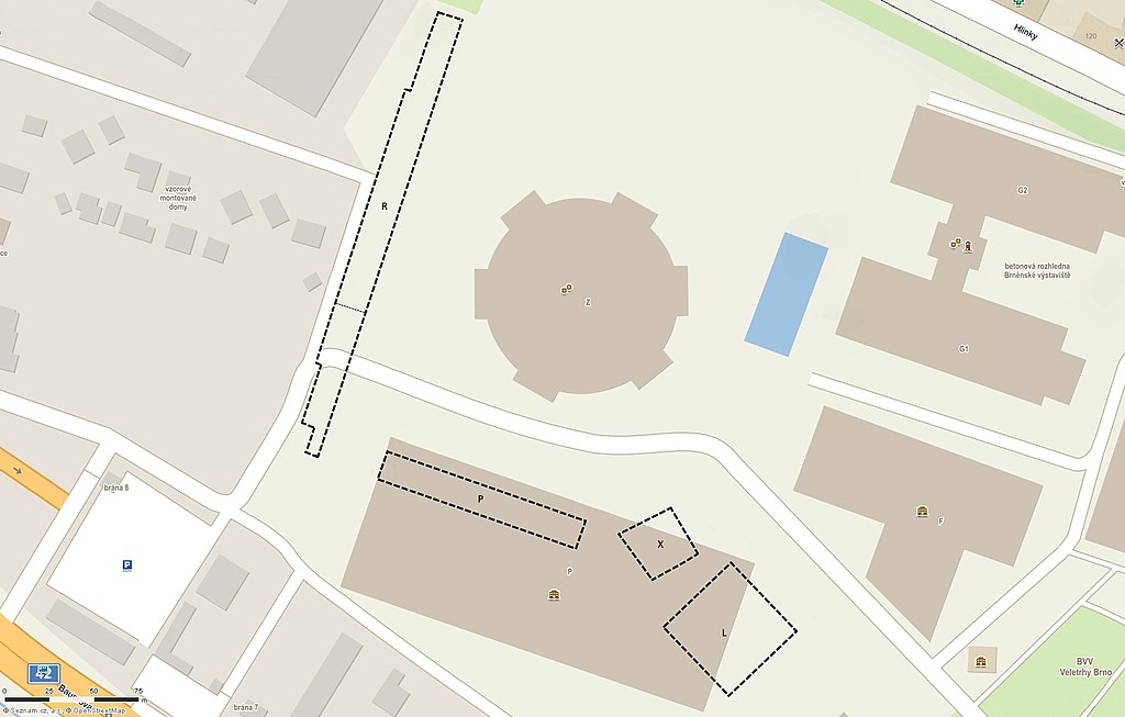
English: Map of the western part of the Brno Exhibition Grounds with contours of the demolished pavilions R, P, X and L. The southern part of pavilion R (below the narrow dashed line) was demolished in 1990s, the rest collapsed in 2010. Pavilions P, L and X were demolished in 2008 to make space for the new Pavillion P.
Čeština: Mapa západní části brněnského výstaviště s obrysy zbouraných pavilonů R, P, X a L. Jižní část pavilonu R (pod tenkou přerušovanou čárou) byla zbourána v 90. letech 20. století, zbytek se zřítil v roce 2010. Pavilony P, L a X byly demolovány v roce 2008, aby uvolnily místo novému pavilonu P. |
| Date | |
| Source | Mapy.cz, https://mapy.cz/s/2Eqdl, https://mapy.cz/s/2Eqdp; http://gis.brno.cz/mapa/historicka-ortofota/?c=-600577.35%3A-1161120.05&z=9&lb=ofakt&ly=&lbp=88 |
| Author | Mapy.cz: © Seznam.cz, a.s.; contours of the former pavilions drawn by Jan Kameníček (talk) |
| Camera location | | View this and other nearby images on: OpenStreetMap |
|---|
This image was acquired during the event Wikivýstaviště.
|
Licensing[edit]
| This screenshot comes from the map server Mapy.cz under a CC license. Their licence conditions of map bases states: "The Screenshot may also be distributed (i.e. in addition to the conditions already described) under the Creative Commons 4.0 license (CC-BY-SA 4.0) by indicating authors and sources and distributing them under the same license." |
| To the uploader: You must provide a link (URL) to the original file and the authorship information if available. |
This file is licensed under the Creative Commons Attribution-Share Alike 4.0 International license. Attribution: Mapy.cz: © Seznam.cz, a.s., © AOPK ČR – ochrana přírody a krajiny
|
File history
Click on a date/time to view the file as it appeared at that time.
| Date/Time | Thumbnail | Dimensions | User | Comment | |
|---|---|---|---|---|---|
| current | 11:15, 10 June 2018 | | 1,613 × 1,029 (361 KB) | Jan.Kamenicek (talk | contribs) | Improved the original shape of the Pavilion R before the partial demolition in 1990s. |
| 23:09, 16 May 2018 |  | 1,613 × 1,029 (364 KB) | Jan.Kamenicek (talk | contribs) | User created page with UploadWizard |
You cannot overwrite this file.
File usage on Commons
The following 4 pages use this file:
File usage on other wikis
The following other wikis use this file: