File:France 1812.png
Jump to navigation
Jump to search
No higher resolution available.
France_1812.png (415 × 397 pixels, file size: 62 KB, MIME type: image/png)
Captions
Captions
Add a one-line explanation of what this file represents
Summary
[edit]
| Description |
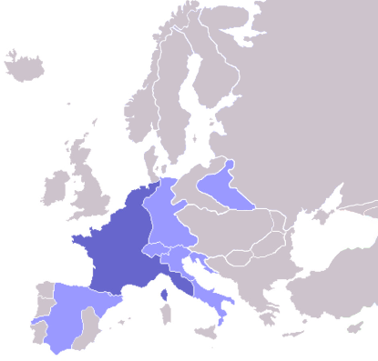
English: Map of the First French Empire in 1812, with the Empire in dark blue and satellite states in light blue. |
| Date |
17 October 2008 (original upload date) |
| Source | Own work (Original text: I created this work entirely by myself.) |
| Author | ZenCopain (talk) |

|
This historical map image could be re-created using vector graphics as an SVG file. This has several advantages; see Commons:Media for cleanup for more information. If an SVG form of this image is available, please upload it and afterwards replace this template with
{{vector version available|new image name}}.
It is recommended to name the SVG file “France 1812.svg”—then the template Vector version available (or Vva) does not need the new image name parameter. |
Licensing
[edit]
| This work has been released into the public domain by its author, ZenCopain at English Wikipedia. This applies worldwide. In some countries this may not be legally possible; if so: ZenCopain grants anyone the right to use this work for any purpose, without any conditions, unless such conditions are required by law. |
Original upload log
[edit]
Transferred from en.wikipedia to Commons by Broadbeer using CommonsHelper.
The original description page was here. All following user names refer to en.wikipedia.
- 2008-10-17 22:16 ZenCopain 415×422× (13703 bytes) {{Information |Description= |Source=I created this work entirely by myself. |Date= [[2008]] |Author=~~~ |other_versions= }}
File history
Click on a date/time to view the file as it appeared at that time.
| Date/Time | Thumbnail | Dimensions | User | Comment | |
|---|---|---|---|---|---|
| current | 17:33, 11 October 2022 | | 415 × 397 (62 KB) | Рагин1987 (talk | contribs) | Extended map |
| 15:21, 13 November 2008 |  | 415 × 422 (13 KB) | File Upload Bot (Magnus Manske) (talk | contribs) | {{BotMoveToCommons|en.wikipedia}} {{Information |Description={{en|Map of the First French Empire in 1812, with the Empire in dark blue and satellite states in light blue.}} |Source=Transferred from [http://en.wikipedia.org en.wikipedia]; transferred to C |
You cannot overwrite this file.
File usage on Commons
There are no pages that use this file.