File:GBHGIS meta architecture.gif
Jump to navigation
Jump to search
No higher resolution available.
GBHGIS_meta_architecture.gif (310 × 218 pixels, file size: 9 KB, MIME type: image/gif)
Captions
Captions
Add a one-line explanation of what this file represents

|
This diagram image could be re-created using vector graphics as an SVG file. This has several advantages; see Commons:Media for cleanup for more information. If an SVG form of this image is available, please upload it and afterwards replace this template with
{{vector version available|new image name}}.
It is recommended to name the SVG file “GBHGIS meta architecture.svg”—then the template Vector version available (or Vva) does not need the new image name parameter. |
Summary[edit]
| Description |
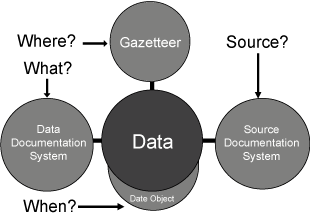
English: Diagram showing the high-level architecture of the Great Britain Historical GIS. This diagram was drawn by Humphrey Southall, originally in 2004, and illustrates a data architecture he developed, so inclusion by him in a Wikipedia page he mainly wrote is not a problem. |
| Date | 2 May 2007 (original upload date) |
| Source | Transferred from en.wikipedia to Commons by Ronhjones. |
| Author | Humphrey.Southall at en.wikipedia |
Licensing[edit]
Humphrey.Southall at the English-language Wikipedia, the copyright holder of this work, hereby publishes it under the following license:
| This file is licensed under the Creative Commons Attribution-Share Alike 3.0 Unported license. Subject to disclaimers. | ||
| Attribution: Humphrey.Southall at the English-language Wikipedia | ||
| ||
| This licensing tag was added to this file as part of the GFDL licensing update. |

|
Permission is granted to copy, distribute and/or modify this document under the terms of the GNU Free Documentation License, Version 1.2 or any later version published by the Free Software Foundation; with no Invariant Sections, no Front-Cover Texts, and no Back-Cover Texts. A copy of the license is included in the section entitled GNU Free Documentation License. Subject to disclaimers. |
Original upload log[edit]
The original description page was here. All following user names refer to en.wikipedia.
Upload date | User | Bytes | Dimensions | Comment
- 2007-05-02 13:39 (UTC) | Humphrey.Southall | 9400 (bytes) | 310×218 | Diagram showing the high-level architecture of the Great Britain Historical GIS. This diagram was drawn by Humphrey Southall, originally in 2004, and illustrates a data architecture he developed, so inclusion by him in a Wikipedia page he mainly wrote is
File history
Click on a date/time to view the file as it appeared at that time.
| Date/Time | Thumbnail | Dimensions | User | Comment | |
|---|---|---|---|---|---|
| current | 17:50, 15 January 2012 | | 310 × 218 (9 KB) | Ronhjones (talk | contribs) | (Original text) : Diagram showing the high-level architecture of the Great Britain Historical GIS. This diagram was drawn by Humphrey Southall, originally in 2004, and illustrates a data architecture he developed, so inclusion by him in a Wikipedia page h |
You cannot overwrite this file.
File usage on Commons
The following page uses this file:
File usage on other wikis
The following other wikis use this file:
- Usage on en.wikipedia.org