File:Garbh Eilean2.jpg
Jump to navigation
Jump to search

Size of this preview: 386 × 600 pixels. Other resolutions: 154 × 240 pixels | 412 × 640 pixels.
Original file (412 × 640 pixels, file size: 61 KB, MIME type: image/jpeg)
Captions
Captions
Add a one-line explanation of what this file represents
| Camera location | | View this and other nearby images on: OpenStreetMap |
|---|
| Object location | | View this and other nearby images on: OpenStreetMap |
|---|
_region:GB-SCT_heading:315.00&language=en)
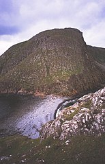
| Description | Beach between the Shiants. The two main islands of the Shiants (Garbh Eilean and Eilean nan Tigh) are joined by a beach which is sometimes inundated. The gap between the two steep islands is a motorway for auks. The Shiants are very rich in birdlife. Taken from above the house on Eilean nan Tigh, looking north to Garbh Eilean. |
| Date | |
| Source | Geograph |
| Author | Richard Webb |

|
This image was taken from the Geograph project collection. See this photograph's page on the Geograph website for the photographer's contact details. The copyright on this image is owned by Richard Webb and is licensed for reuse under the Creative Commons Attribution-ShareAlike 2.0 license.
|
This file is licensed under the Creative Commons Attribution-Share Alike 2.0 Generic license.
Attribution: Richard Webb
- You are free:
- to share – to copy, distribute and transmit the work
- to remix – to adapt the work
- Under the following conditions:
- attribution – You must give appropriate credit, provide a link to the license, and indicate if changes were made. You may do so in any reasonable manner, but not in any way that suggests the licensor endorses you or your use.
- share alike – If you remix, transform, or build upon the material, you must distribute your contributions under the same or compatible license as the original.
File history
Click on a date/time to view the file as it appeared at that time.
| Date/Time | Thumbnail | Dimensions | User | Comment | |
|---|---|---|---|---|---|
| current | 13:04, 21 July 2007 | | 412 × 640 (61 KB) | Finavon (talk | contribs) | {{Information |Description=Beach between the Shiants. The two main islands of the Shiants (Garbh Eilean and Eilean nan Tigh) are joined by a beach which is sometimes inundated. The gap between the two steep islands is a motorway for auks. The Shiants are |
You cannot overwrite this file.
File usage on Commons
There are no pages that use this file.
File usage on other wikis
The following other wikis use this file:
- Usage on en.wikipedia.org
- Usage on ga.wikipedia.org
- Usage on nn.wikipedia.org