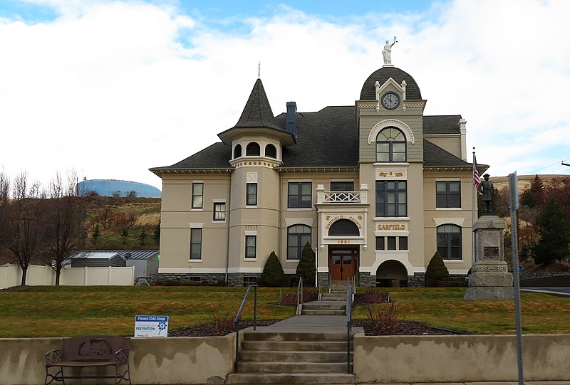
File:Garfield County Courthouse, Pomeroy, Washington (31499018947).jpg

Original file (3,956 × 2,673 pixels, file size: 7.41 MB, MIME type: image/jpeg)
Captions
Captions
Summary[edit]
| DescriptionGarfield County Courthouse, Pomeroy, Washington (31499018947).jpg |
Garfield County is a county located in the U.S. state of Washington. As of the 2010 census, the population was 2,266, making it the least populous county in Washington; with about 3.2 inhabitants per square mile (1.2/km2), it is also the least densely populated county in Washington. The county seat and only city is Pomeroy. The area delineated by the future Washington state boundary began to be colonized at the start of the nineteenth century, both by Americans and British. However, the majority of British exploration and interest in the land was due to the fur trade, whereas American settlers were principally seeking land for agriculture and cattle raising. The Treaty of 1818 provided for the creation of a British and American condominium over the region. During this period, the future Washington Territory was divided into two administrative zones: Clark County and Lewis County (made official in 1845). However, the condominium arrangement was unwieldy, leading to continuous disputes and occasional conflict; it was abolished by an 1846 treaty that established a boundary between British and American possessions that survives as today's Canada–United States border. In 1854, Skamania County was split from the original Clark County. Also in 1854, Walla Walla County was split from the new Skamania County. In 1875, Columbia County was split from Walla Walla County, and on November 29, 1881, a portion of Columbia County was set off to form Garfield County. The original Garfield County was reduced in size in 1883 when its southeastern area was partitioned off to form Asotin County. It was named for the late U.S. President James A. Garfield, who had been assassinated a few weeks prior. <a href="https://en.wikipedia.org/wiki/Garfield_County,_Washington" rel="noreferrer nofollow">en.wikipedia.org/wiki/Garfield_County,_Washington</a> <a href="https://en.wikipedia.org/wiki/Wikipedia:Text_of_Creative_Commons_Attribution-ShareAlike_3.0_Unported_License" rel="noreferrer nofollow">en.wikipedia.org/wiki/Wikipedia:Text_of_Creative_Commons_...</a> |
| Date | |
| Source | Garfield County Courthouse, Pomeroy, Washington |
| Author | Ken Lund from Reno, Nevada, USA |
Licensing[edit]
- You are free:
- to share – to copy, distribute and transmit the work
- to remix – to adapt the work
- Under the following conditions:
- attribution – You must give appropriate credit, provide a link to the license, and indicate if changes were made. You may do so in any reasonable manner, but not in any way that suggests the licensor endorses you or your use.
- share alike – If you remix, transform, or build upon the material, you must distribute your contributions under the same or compatible license as the original.
| This image was originally posted to Flickr by Ken Lund at https://flickr.com/photos/75683070@N00/31499018947. It was reviewed on 23 June 2022 by FlickreviewR 2 and was confirmed to be licensed under the terms of the cc-by-sa-2.0. |
23 June 2022
File history
Click on a date/time to view the file as it appeared at that time.
| Date/Time | Thumbnail | Dimensions | User | Comment | |
|---|---|---|---|---|---|
| current | 14:24, 23 June 2022 |  | 3,956 × 2,673 (7.41 MB) | Leonaardog (talk | contribs) | Transferred from Flickr via #flickr2commons |
You cannot overwrite this file.
File usage on Commons
There are no pages that use this file.
Metadata
This file contains additional information such as Exif metadata which may have been added by the digital camera, scanner, or software program used to create or digitize it. If the file has been modified from its original state, some details such as the timestamp may not fully reflect those of the original file. The timestamp is only as accurate as the clock in the camera, and it may be completely wrong.
| Camera manufacturer | Canon |
|---|---|
| Camera model | Canon PowerShot SX720 HS |
| Exposure time | 1/250 sec (0.004) |
| F-number | f/4 |
| ISO speed rating | 80 |
| Date and time of data generation | 11:01, 23 December 2018 |
| Lens focal length | 4.3 mm |
| Horizontal resolution | 180 dpi |
| Vertical resolution | 180 dpi |
| File change date and time | 11:01, 23 December 2018 |
| Y and C positioning | Centered |
| Exif version | 2.3 |
| Date and time of digitizing | 11:01, 23 December 2018 |
| Meaning of each component |
|
| APEX shutter speed | 7.9715435469963 |
| APEX aperture | 4 |
| APEX exposure bias | −0.33333333333333 |
| Maximum land aperture | 3.4449320498301 APEX (f/3.3) |
| Metering mode | Pattern |
| Flash | Flash did not fire, compulsory flash suppression |
| DateTime subseconds | 46 |
| DateTimeOriginal subseconds | 46 |
| DateTimeDigitized subseconds | 46 |
| Supported Flashpix version | 1 |
| Color space | sRGB |
| Focal plane X resolution | 21,159.183673469 |
| Focal plane Y resolution | 21,130.434782609 |
| Focal plane resolution unit | inches |
| Sensing method | One-chip color area sensor |
| File source | Digital still camera |
| Custom image processing | Custom process |
| Exposure mode | Manual exposure |
| White balance | Auto white balance |
| Digital zoom ratio | 1 |
| Scene capture type | Standard |
| GPS tag version | 0.0.3.2 |
| Rating (out of 5) | 0 |