File:Gaza closure December 2012-crop.jpg
Jump to navigation
Jump to search

Size of this preview: 268 × 600 pixels. Other resolutions: 107 × 240 pixels | 214 × 480 pixels | 343 × 768 pixels | 457 × 1,024 pixels | 915 × 2,048 pixels | 3,107 × 6,952 pixels.
Original file (3,107 × 6,952 pixels, file size: 2.76 MB, MIME type: image/jpeg)
Captions
Captions
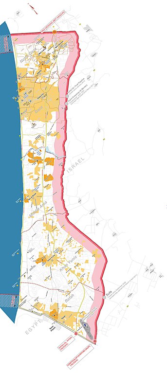
Detailed map of the Gaza Strip in 2012
Summary[edit]
| Description |
English: Gaza Strip with Israeli-controlled borders and limited fishing zone, as of December 2012. In pink the security zone enforced by Israel, where no build up is allowed and which is virtually a no-go area. Based on Closure Map: Gaza Strip Access and Closure, published by United Nations Office for the Coordination of Humanitarian Affairs (OCHAoPt), 22 February 2013. |
| Date | |
| Source | Own work |
| Author | Wickey |
| Other versions |
|

Licensing[edit]
I, the copyright holder of this work, hereby publish it under the following license:
| This file is made available under the Creative Commons CC0 1.0 Universal Public Domain Dedication. | |
| The person who associated a work with this deed has dedicated the work to the public domain by waiving all of their rights to the work worldwide under copyright law, including all related and neighboring rights, to the extent allowed by law. You can copy, modify, distribute and perform the work, even for commercial purposes, all without asking permission.
|
File history
Click on a date/time to view the file as it appeared at that time.
| Date/Time | Thumbnail | Dimensions | User | Comment | |
|---|---|---|---|---|---|
| current | 17:04, 10 November 2023 | | 3,107 × 6,952 (2.76 MB) | Wickey (talk | contribs) | Uploaded own work with UploadWizard |
You cannot overwrite this file.
File usage on Commons
The following page uses this file:
File usage on other wikis
The following other wikis use this file:
- Usage on nl.wikipedia.org