File:Geologic map SE England & Channel EN.svg
Jump to navigation
Jump to search

Size of this PNG preview of this SVG file: 800 × 518 pixels. Other resolutions: 320 × 207 pixels | 640 × 415 pixels | 1,024 × 663 pixels | 1,280 × 829 pixels | 2,560 × 1,658 pixels | 1,374 × 890 pixels.
Original file (SVG file, nominally 1,374 × 890 pixels, file size: 1.65 MB)
Captions
Captions
Add a one-line explanation of what this file represents
Summary[edit]
| Description |
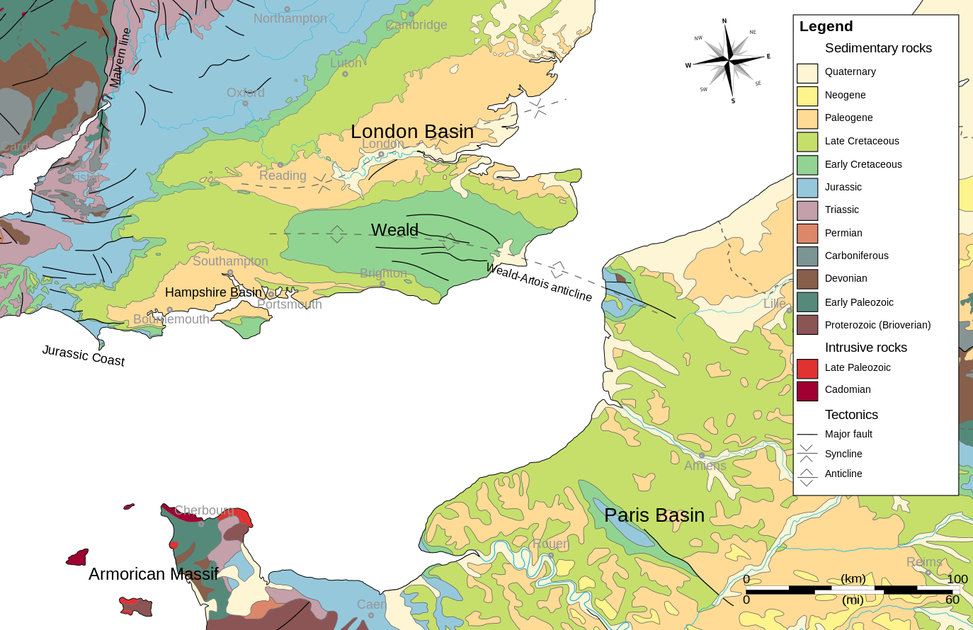
English: Geologic map of southeastern England, the English Channel and Pays-de-Calais.
Based on:
|
| Date | |
| Source | Own work |
| Author | Woudloper |
Licensing[edit]
I, the copyright holder of this work, hereby publish it under the following licenses:

|
Permission is granted to copy, distribute and/or modify this document under the terms of the GNU Free Documentation License, Version 1.2 or any later version published by the Free Software Foundation; with no Invariant Sections, no Front-Cover Texts, and no Back-Cover Texts. A copy of the license is included in the section entitled GNU Free Documentation License. |
This file is licensed under the Creative Commons Attribution-Share Alike 3.0 Unported, 2.5 Generic, 2.0 Generic and 1.0 Generic license.
- You are free:
- to share – to copy, distribute and transmit the work
- to remix – to adapt the work
- Under the following conditions:
- attribution – You must give appropriate credit, provide a link to the license, and indicate if changes were made. You may do so in any reasonable manner, but not in any way that suggests the licensor endorses you or your use.
- share alike – If you remix, transform, or build upon the material, you must distribute your contributions under the same or compatible license as the original.
You may select the license of your choice.
File history
Click on a date/time to view the file as it appeared at that time.
| Date/Time | Thumbnail | Dimensions | User | Comment | |
|---|---|---|---|---|---|
| current | 21:18, 10 October 2009 | | 1,374 × 890 (1.65 MB) | Woudloper (talk | contribs) | and again same problem with a black bar (left bottom) |
| 19:09, 10 October 2009 |  | 1,374 × 890 (1.65 MB) | Woudloper (talk | contribs) | bugs removed | |
| 15:37, 9 October 2009 |  | 1,374 × 890 (2.01 MB) | Woudloper (talk | contribs) | merged Cambrian and Ordovician/Silurian | |
| 15:01, 9 October 2009 |  | 1,374 × 890 (2.01 MB) | Woudloper (talk | contribs) | SVG text to text | |
| 14:59, 9 October 2009 |  | 1,374 × 890 (2.01 MB) | Woudloper (talk | contribs) | {{Information |Description={{en|1=Geologic map of southeastern England, the English Channel and Pays-de-Calais. Based on: *{{Small-caps|British Geological Survey}}; '''2005''': ''Bedrock geology UK South, 1:625 000 scale'' (5<sup>th</sup> ed.), HarperCol |
You cannot overwrite this file.
File usage on Commons
The following page uses this file:
File usage on other wikis
The following other wikis use this file:
- Usage on ca.wikipedia.org
- Usage on de.wikipedia.org
- Usage on en.wikipedia.org
- Usage on es.wikipedia.org
- Usage on et.wikipedia.org
- Usage on fr.wikipedia.org
- Usage on gl.wikipedia.org
- Usage on it.wikipedia.org
- Usage on nl.wikipedia.org
- Usage on pl.wikipedia.org
- Usage on uk.wikipedia.org
Categories:
- Geological maps of England
- Geological maps of Armorican Massif
- SVG topographic maps of France
- SVG maps of England
- SVG geology
- Bedrock geology of the United Kingdom
- Weald Basin
- London Basin
- Hampshire Basin
- Maps of sedimentary basins
- Jurassic Coast
- Anticlines in Europe
- Geological maps of France
- Maps of Paris Basin