File:Geology of Mull.png
Jump to navigation
Jump to search

Size of this preview: 689 × 600 pixels. Other resolutions: 276 × 240 pixels | 552 × 480 pixels | 883 × 768 pixels | 1,177 × 1,024 pixels | 2,354 × 2,048 pixels | 3,452 × 3,004 pixels.
Original file (3,452 × 3,004 pixels, file size: 934 KB, MIME type: image/png)
Captions
Captions
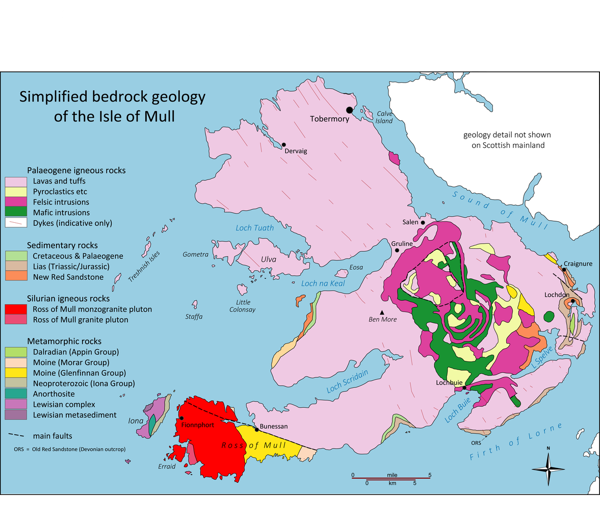
Simplified bedrock geology of the Isle of Mull
Summary
[edit]
| Description |
English: The bedrock geology of the Isle of Mull, Scotland redrawn after BGS maps here |
| Date | |
| Source | Own work |
| Author | Geopersona |
Licensing
[edit]
I, the copyright holder of this work, hereby publish it under the following license:
This file is licensed under the Creative Commons Attribution-Share Alike 4.0 International license.
- You are free:
- to share – to copy, distribute and transmit the work
- to remix – to adapt the work
- Under the following conditions:
- attribution – You must give appropriate credit, provide a link to the license, and indicate if changes were made. You may do so in any reasonable manner, but not in any way that suggests the licensor endorses you or your use.
- share alike – If you remix, transform, or build upon the material, you must distribute your contributions under the same or compatible license as the original.
File history
Click on a date/time to view the file as it appeared at that time.
| Date/Time | Thumbnail | Dimensions | User | Comment | |
|---|---|---|---|---|---|
| current | 10:22, 7 March 2020 | | 3,452 × 3,004 (934 KB) | Geopersona (talk | contribs) | Uploaded own work with UploadWizard |
You cannot overwrite this file.
File usage on Commons
The following page uses this file:
File usage on other wikis
The following other wikis use this file:
- Usage on en.wikipedia.org
Categories:
- Maps of the Isle of Mull
- Geological maps of Scotland
- Bedrock in Scotland
- Bedrock geology of Scotland
- Volcanological maps of Scotland
- Mull volcano
- Maps of volcanoes in the United Kingdom
- Magmatism of Scotland
- Paleogene lavas and tuffs in Scotland
- Paleogene pyroclastic rocks in Scotland
- Paleogene mafic intrusions in Scotland
- Paleogene felsic intrusions in Scotland
- Paleogene magmatic dikes in Scotland
- Cretaceous and Paleogene sedimentary rocks in Scotland
- Lias Group in Scotland
- New Red Sandstone in Scotland
- Ross of Mull monzogranite pluton
- Ross of Mull Granite
- Appin Group (geology)
- Morar Group
- Glenfinnan Group
- Iona Group (geology)
- Anorthosite formations in the United Kingdom
- Lewisian Complex
- Lewisian metasediment
- Faults in Scotland
- Lias Group - maps