File:Grossgliederung Europas-ru.svg
Jump to navigation
Jump to search

Size of this PNG preview of this SVG file: 577 × 599 pixels. Other resolutions: 231 × 240 pixels | 462 × 480 pixels | 740 × 768 pixels | 986 × 1,024 pixels | 1,973 × 2,048 pixels | 683 × 709 pixels.
Original file (SVG file, nominally 683 × 709 pixels, file size: 682 KB)
Captions
Captions
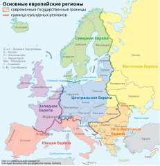
Map of regions and countries of Europe
Summary[edit]
| Description |
[] Aragonés: Rechions europeyas proposatas por Ständiger Ausschuss für geographische Namen (StAGN) Català: Regions europees proposades per Ständiger Ausschuss für geographische Namen (StAGN) Deutsch: Großgliederung Europas, Vorschlag des Ständigen Ausschuss für geographische Namen (StAGN) English: European regions as proposed by Ständiger Ausschuss für geographische Namen (StAGN) Español: Regiones europeas propuestas por Ständiger Ausschuss für geographische Namen (StAGN) Français : Carte des régions d'Europe, en allemand, selon le Ständigen Ausschuss für geographische Namen (StAGN) Hrvatski: Pregled europskih regija po kriterijima kulture i po državnim granicama Polski: Mapa regionów europejskich, w języku niemieckim, wg propozycjiStałego Komitetu ds. Nazw Geograficznych (StAGN) Македонски: Карта на регионите во Европа според ЕУ на македонски. Русский: Европейские регионы Українська: Європейські регіони на основі пропозиції Ständiger Ausschuss für geographische Namen (StAGN) 中文: 欧洲 العربية : خارطة مناطق ودُول أوروپَّا وفقًا لِمُؤسسة Ständiger Ausschuss für geographische Namen (StAGN) |
| Date | |
| Source | Own work using File:Grossgliederung Europas.svg by NordNordWest |
| Author | Mixalbl493 |
| Other versions |
[]
|


Licensing[edit]
I, the copyright holder of this work, hereby publish it under the following licenses:
This file is licensed under the Creative Commons Attribution-Share Alike 3.0 Unported license.
- You are free:
- to share – to copy, distribute and transmit the work
- to remix – to adapt the work
- Under the following conditions:
- attribution – You must give appropriate credit, provide a link to the license, and indicate if changes were made. You may do so in any reasonable manner, but not in any way that suggests the licensor endorses you or your use.
- share alike – If you remix, transform, or build upon the material, you must distribute your contributions under the same or compatible license as the original.

|
Permission is granted to copy, distribute and/or modify this document under the terms of the GNU Free Documentation License, Version 1.2 or any later version published by the Free Software Foundation; with no Invariant Sections, no Front-Cover Texts, and no Back-Cover Texts. A copy of the license is included in the section entitled GNU Free Documentation License. |
You may select the license of your choice.
File history
Click on a date/time to view the file as it appeared at that time.
| Date/Time | Thumbnail | Dimensions | User | Comment | |
|---|---|---|---|---|---|
| current | 07:45, 13 February 2012 | | 683 × 709 (682 KB) | MBH (talk | contribs) | fixed: Южное море --> Северное море |
| 07:36, 13 February 2012 |  | 683 × 709 (682 KB) | MBH (talk | contribs) | fixed errors: Голландия --> Нидерланды, "Ч" вместо "М" для Черногории, Юговосточная --> Юго-Восточная | |
| 07:30, 13 February 2012 |  | 683 × 709 (682 KB) | MBH (talk | contribs) | fixed error: Бельгия --> Венгрия | |
| 16:37, 18 July 2011 |  | 683 × 709 (682 KB) | Spectorman (talk | contribs) | corrected mistake Eastern Europe - Western Europe | |
| 13:30, 15 March 2011 |  | 683 × 709 (682 KB) | Kmmixalbl4 (talk | contribs) | {{Information |Description ={{ru|1=Европейские регионы}} |Source ={{own}} |Author =Mixalbl493 |Date =2011-03-15 |Permission = |other_versions =Файл:Grossgliederung_Europas.png }} |
You cannot overwrite this file.
File usage on Commons
The following 18 pages use this file:
- File:Grossgliederung Europas-an.svg
- File:Grossgliederung Europas-ar.svg
- File:Grossgliederung Europas-ca.svg
- File:Grossgliederung Europas-en.svg
- File:Grossgliederung Europas-es.svg
- File:Grossgliederung Europas-fr.png
- File:Grossgliederung Europas-fr.svg
- File:Grossgliederung Europas-hr.svg
- File:Grossgliederung Europas-hy.png
- File:Grossgliederung Europas-jv.svg
- File:Grossgliederung Europas-lb.svg
- File:Grossgliederung Europas-mk.svg
- File:Grossgliederung Europas-ru.svg
- File:Grossgliederung Europas-ua.svg
- File:Grossgliederung Europas-zh.svg
- File:Grossgliederung Europas.png
- File:Grossgliederung Europas.svg
- Template:Other versions/Grossgliederung Europas
File usage on other wikis
The following other wikis use this file:
- Usage on ba.wikipedia.org
- Usage on cv.wikipedia.org
- Usage on ru.wikipedia.org