File:HAI 2014 values-DOPA nos.png

Original file (900 × 1,584 pixels, file size: 571 KB, MIME type: image/png)
Captions
Captions
Summary[edit]
| DescriptionHAI 2014 values-DOPA nos.png |
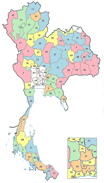
English: Map of Thailand with the provinces numbered (DOPA) and five colours added accordance to HAI 2014 ranking.
Colors show HAI 2014 values (76 provinces): |
| Date | |
| Source |
This file was derived from: BlankMap-Thailand-provinces.svg |
| Author | Paul_012 *derivative work:SietsL |
| This is a retouched picture, which means that it has been digitally altered from its original version. Modifications: Added provincial numbers (DOPA) and added five colours accordance to HAI 2014 values. The original can be viewed here: BlankMap-Thailand-provinces.svg:
|
- Human Achievement Index (HAI) 2014 is part of "Thailand Human Development report 2014" by United Nations Development Programme (UNDP) in Thailand.
- DOPA is Department of Provincial Administration (Thailand)
Licensing[edit]
- You are free:
- to share – to copy, distribute and transmit the work
- to remix – to adapt the work
- Under the following conditions:
- attribution – You must give appropriate credit, provide a link to the license, and indicate if changes were made. You may do so in any reasonable manner, but not in any way that suggests the licensor endorses you or your use.
- share alike – If you remix, transform, or build upon the material, you must distribute your contributions under the same or compatible license as the original.
Original upload log[edit]
This image is a derivative work of the following image:
- File:BlankMap-Thailand-provinces.svg licensed with Cc-by-sa-3.0
- 7 October 2011 Paul_012
1051x1849 (1MB) "classified rivers{{Information|Description={{en|1=Map of Thailand (in location style);modification of [[:File:Thailand location map.svg]] to allow colouring of provinces using CSS.
File history
Click on a date/time to view the file as it appeared at that time.
| Date/Time | Thumbnail | Dimensions | User | Comment | |
|---|---|---|---|---|---|
| current | 08:33, 22 April 2019 |  | 900 × 1,584 (571 KB) | SietsL (talk | contribs) | User created page with UploadWizard |
You cannot overwrite this file.
File usage on Commons
There are no pages that use this file.
Metadata
This file contains additional information such as Exif metadata which may have been added by the digital camera, scanner, or software program used to create or digitize it. If the file has been modified from its original state, some details such as the timestamp may not fully reflect those of the original file. The timestamp is only as accurate as the clock in the camera, and it may be completely wrong.
| File change date and time | 08:22, 22 April 2019 |
|---|