File:Hainanincidentmap.png
Jump to navigation
Jump to search
Size of this preview: 765 × 600 pixels. Other resolutions: 306 × 240 pixels | 613 × 480 pixels | 865 × 678 pixels.
Original file (865 × 678 pixels, file size: 45 KB, MIME type: image/png)
Captions
Captions
Add a one-line explanation of what this file represents
Summary[edit]
| Description |
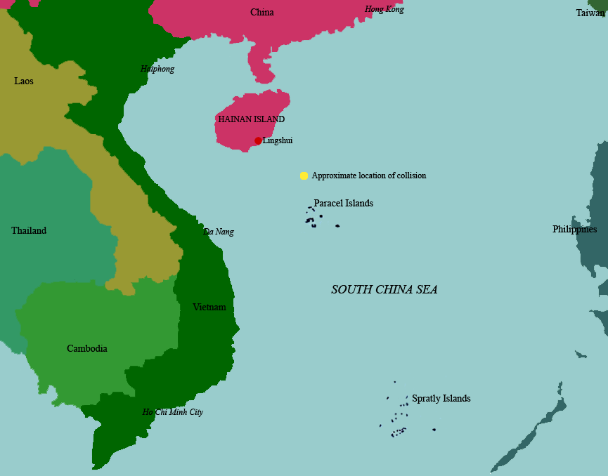
English: Map of South china sea showing location of the Hainan Island incident. Used https://web.archive.org/web/20051226191538/www.pacom.mil/imagery/archive/0104photos/010401cinc-h.jpg, File:Schina sea 88.png and Google Maps as references |
| Date | |
| Source | Own work |
| Author | Guinnog |
Licensing[edit]
I, the copyright holder of this work, hereby publish it under the following licences:
This file is licensed under the Creative Commons Attribution-Share Alike 3.0 Unported licence.
- You are free:
- to share – to copy, distribute and transmit the work
- to remix – to adapt the work
- Under the following conditions:
- attribution – You must give appropriate credit, provide a link to the licence, and indicate if changes were made. You may do so in any reasonable manner, but not in any way that suggests the licensor endorses you or your use.
- share alike – If you remix, transform, or build upon the material, you must distribute your contributions under the same or compatible licence as the original.

|
Permission is granted to copy, distribute and/or modify this document under the terms of the GNU Free Documentation Licence, Version 1.2 or any later version published by the Free Software Foundation; with no Invariant Sections, no Front-Cover Texts, and no Back-Cover Texts. A copy of the licence is included in the section entitled GNU Free Documentation Licence. |
You may select the licence of your choice.
File history
Click on a date/time to view the file as it appeared at that time.
| Date/Time | Thumbnail | Dimensions | User | Comment | |
|---|---|---|---|---|---|
| current | 09:59, 5 April 2009 | | 865 × 678 (45 KB) | Guinnog (talk | contribs) | added islands |
| 04:47, 5 April 2009 |  | 865 × 678 (41 KB) | Guinnog (talk | contribs) | Cleanup, add missing caption | |
| 02:42, 5 April 2009 |  | 865 × 678 (50 KB) | Guinnog (talk | contribs) | {{Information |Description={{en|1=Map of South china sea showing location of the Hainan Island incident. Used http://web.archive.org/web/20051226191538/www.pacom.mil/imagery/archive/0104photos/010401cinc-h.jpg and Google Maps as references}} |Source=Own w |
You cannot overwrite this file.
File usage on Commons
The following 2 pages use this file:
File usage on other wikis
The following other wikis use this file:
- Usage on ar.wikipedia.org
- Usage on en.wikipedia.org
- Usage on es.wikipedia.org
- Usage on fr.wikipedia.org
- Usage on ja.wikipedia.org
- Usage on ko.wikipedia.org
- Usage on www.wikidata.org