File:Hasanwayhids map-ar.png
Jump to navigation
Jump to search

Size of this preview: 598 × 600 pixels. Other resolutions: 239 × 240 pixels | 479 × 480 pixels | 790 × 792 pixels.
Original file (790 × 792 pixels, file size: 35 KB, MIME type: image/png)
Captions
Captions
Hasanwayhid dynasty
Summary[edit]
| Description |
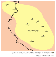
العربية: خريطة تُصوِّر الحُدُود التقريبيَّة للإمارة الحسنويَّة خلال القرنين العاشر والحادي عشر الميلاديين. |
||||||||||||||||||||
| Date | |||||||||||||||||||||
| Source |
This file was derived from: Hasanwayhids map.png |
||||||||||||||||||||
| Author |
|
||||||||||||||||||||
| Other versions | English | ||||||||||||||||||||

Licensing[edit]
I, the copyright holder of this work, hereby publish it under the following license:
| This file is made available under the Creative Commons CC0 1.0 Universal Public Domain Dedication. | |
| The person who associated a work with this deed has dedicated the work to the public domain by waiving all of their rights to the work worldwide under copyright law, including all related and neighboring rights, to the extent allowed by law. You can copy, modify, distribute and perform the work, even for commercial purposes, all without asking permission.
|
File history
Click on a date/time to view the file as it appeared at that time.
| Date/Time | Thumbnail | Dimensions | User | Comment | |
|---|---|---|---|---|---|
| current | 17:09, 12 February 2023 | | 790 × 792 (35 KB) | باسم (talk | contribs) | Uploaded a work by * Original: PANONIAN * Derivative: {{Creator|wikidata=Q64226228}} from {{Derived from|1=Hasanwayhids map.png}} with UploadWizard |
You cannot overwrite this file.
File usage on Commons
There are no pages that use this file.
File usage on other wikis
The following other wikis use this file:
- Usage on ar.wikipedia.org
- Usage on arz.wikipedia.org