File:Hecktstraße.jpg
Original file (4,248 × 5,664 pixels, file size: 6.93 MB, MIME type: image/jpeg)
Captions
Summary
[edit]DescriptionHecktstraße.jpg |
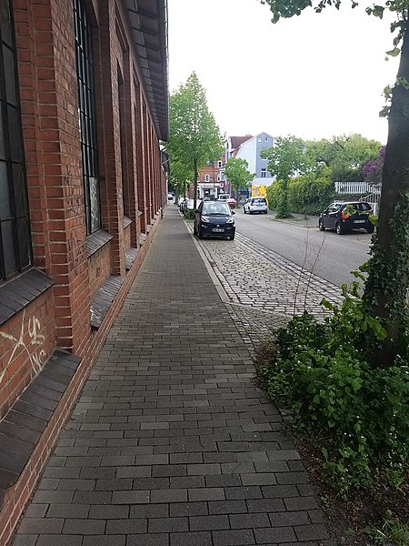
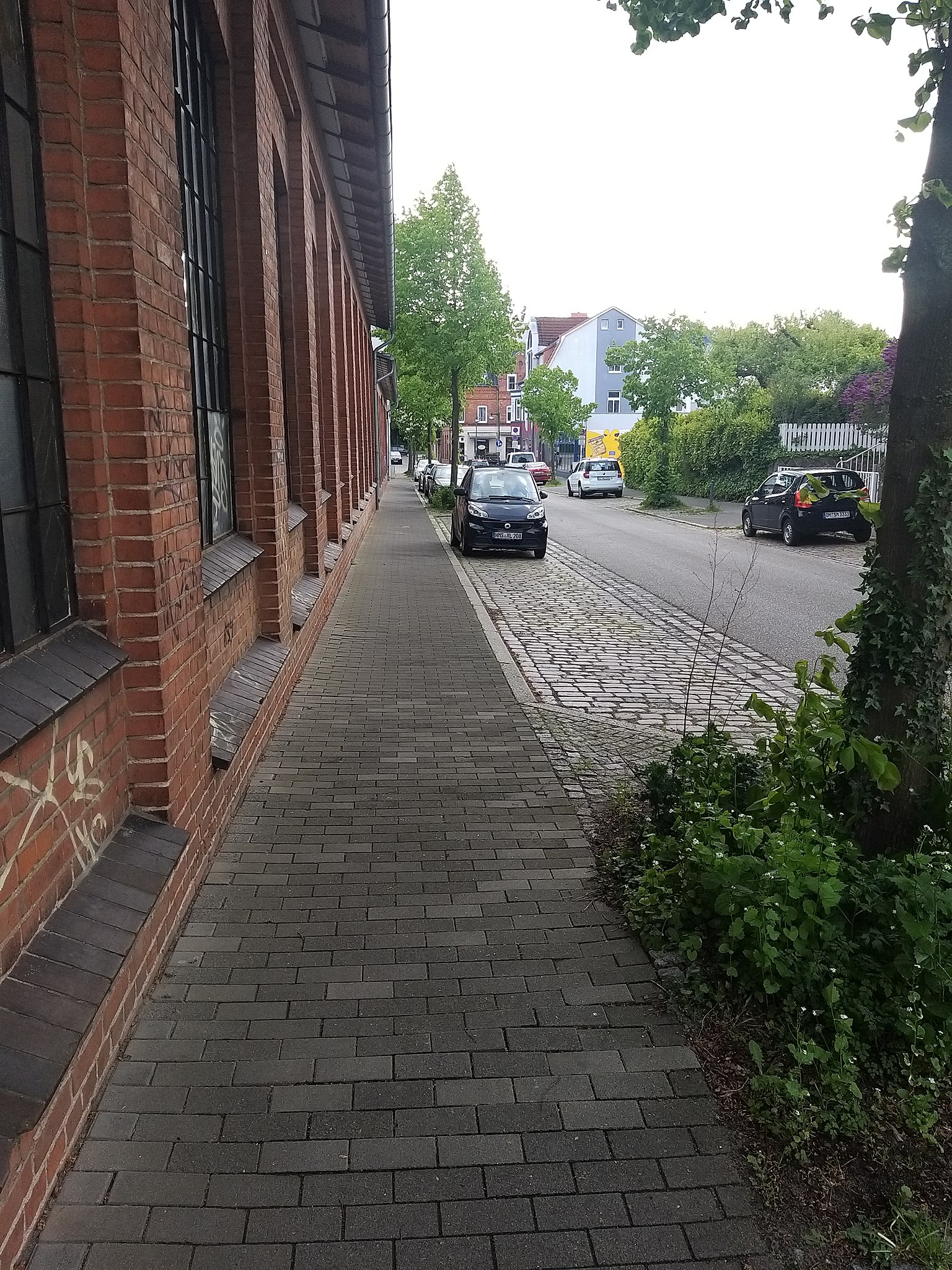
Deutsch: Hecktstraße, links zu Friedrichsort, rechts zu Pries |
Date | |
Source | Own work |
Author | Christian Alexander Tietgen |
Camera location | 54° 23′ 48.51″ N, 10° 10′ 26.03″ E | View this and other nearby images on: OpenStreetMap | 54.396809; 10.173897 |
---|
Vergleiche https://www.unser-stadtplan.de/Stadtplan/Kiel/str/Hecktstrasse.map
Licensing
[edit]- You are free:
- to share – to copy, distribute and transmit the work
- to remix – to adapt the work
- Under the following conditions:
- attribution – You must give appropriate credit, provide a link to the license, and indicate if changes were made. You may do so in any reasonable manner, but not in any way that suggests the licensor endorses you or your use.
File history
Click on a date/time to view the file as it appeared at that time.
Date/Time | Thumbnail | Dimensions | User | Comment | |
---|---|---|---|---|---|
current | 13:48, 13 June 2020 | 4,248 × 5,664 (6.93 MB) | Christian aus Schleswig-Holstein (talk | contribs) | Uploaded own work with UploadWizard |
You cannot overwrite this file.
File usage on Commons
There are no pages that use this file.
Metadata
This file contains additional information such as Exif metadata which may have been added by the digital camera, scanner, or software program used to create or digitize it. If the file has been modified from its original state, some details such as the timestamp may not fully reflect those of the original file. The timestamp is only as accurate as the clock in the camera, and it may be completely wrong.
Camera manufacturer | samsung |
---|---|
Camera model | SM-A920F |
Exposure time | 1/473 sec (0.0021141649048626) |
F-number | f/1.7 |
ISO speed rating | 50 |
Date and time of data generation | 17:35, 12 May 2020 |
Lens focal length | 3.93 mm |
User comments | @ÍP0ݤxm‘ô‡Svô‡Svö™\ö™\8ÝdMH59ö™\ô‡Sv8ÝdM8ÝdM¾Ùê¹QAWBA[%vÂ×È89¸ÛV§^ÂÈü
1Éc
¼"¢î_ÒÓÃr>´PÔJÖ„ò # âúwg«Ï°ªÔª ì‘t‡©!»5=)Ð û`î Š715ûe'ã$e<ì ½ T (¹&›öQ .7 ”‰ a x Á Èe(>ªÞìÃ4 “ Ôú âÖgpwë?X“+ ç + ¦ ƒ 8ä ¼2Ó NïˆD‰ ¨ ù ð ‰,èìM…L¥â K¬7f ñ Ý «kÆWuíÇ ; þå,Ç 0Ò { õ ?[–’ û ÊÕ$»3 ·Í/ 8 [ º q ˜ Þ · ¯) œ`N · í‹G.’k@C$ ÑÇÿ[ ºPæ£-E .¶W“
yN e'?&G à1Ú'¸Ô „¤ TX 5/3Š()0Ú/+& qqô Ž90º*åô5C01š OH¯ö( üA„WH9?49Ø P ” 'ÆbJER?À5µGKÎà2ô œG³+á3\c3„¹í*aÒa }J2©L!Žök1þ—ŠŒ e©>u³(׆@<Êe‡6Ò (Hi¶îëE#Uò,ýŽ‹ºƒ¤—lƒ‡–ïÁÈJÍO p ß çñ!S¼ Ãcå T×Zýäúͱ±¼üÏÒoä Ì & x òJ Å¡'ýÒȤ‹ > S ºm ÛA ¬ÐàÊýÅ@µ£-E .¶W“
yN e'?&G à1Ú'¸Ô „¤ TX 5/3Š()0Ú/+& qqô Ž90º*åô5C01š OH¯ö( üA„WH9?49Ø P ” 'ÆbJER?À5µGKÎà2ô œG³+á3\c3„¹í*aÒa }J2©L!Žök1þ—ŠŒ e©>u³(׆@<Êe‡6Ò (Hi¶îëE#Uò,ýŽ‹ºƒ¤—lƒ‡–ïÁÈJÍO p ß çñ!S¼ Ãcå T×Zýäúͱ±¼üÏÒoä Ì & x òJ Å¡'ýÒȤ‹ > S ºm ÛA ¬ÐàÊýÅ@µ¹å!¢ZI¤vÉìA\ÎoÌïœ<~_ ÜSŠÀ±à:›`ÉÂày`÷q/q |é$M9ñ(edm…eýr ?í‹ÀµbšßÙ%Ø'&sÖ…xË\É ®XŸ6-„%¼ š# ¼•2 _?xdV„ÑÆi÷ " =g ù!Ô L ?£;O‘0 «ù âÜÒË ˜J£h6 «ƒÓ|TWÑë ¦È ²Ç6 Ò@¡¼¹‰Æè í‘a%XAI6 Ä~}}TúÎ{ëm“. ‰ Ð Ñ w ì ~ bÆ"Î -À ˆËÒÏ2ÎP î } q5â(QØ÷^êÕÜ t °G Æ à ªP_[ ´êe¶þ ÎÍ Ô ¹Jò¹*òOå?{í9¿é’…½Ì#²½Žÿ¤?„êN¾6‡£=;5¿ eÐ?òOå?{í9¿é’…½Ì#²½Žÿ¤?„êN¾6‡£=;5¿ eÐ?Kß?€?Blõ?ÌÜ?€?åæ÷?®G?¤p}?*Jò9C*¹–2L,¤Ü€€€€€€€€€€€€€€€€€€€€€€ 833Ã@…ë@îA€?z=~?`h?j.?ÌÜ?€?åæ÷?Jò9C`h?j.?€?€?×£€@Q£€?{ó?Ç´û>`h?j.?`h?j.?ÌÜ?€?åæ÷?®G?¤p}?Kß?€?Blõ?Àš¡>]0]?0Gñ>ål?÷ó?¥ì>÷ó?¥ì>Ùõ?Þ¸>Ùõ?Þ¸>ö7]? Èš>ߣš?°d>Ùõ?Þ¸>÷ó?¥ì>ö7]? Èš>ö7]? Èš>QCAF¨>´†L.<E]P}càÚq€(3ܵæH01Èå`x·’0“ðæ“(©GG[QG<0EEEEÿÿÿÿÿÿÿÿÿÿÿÿÿÿÿÿÿÿÿÿÿÿÿÿÿÿÿÿÿÿÿÿÿÿÿÿÿÿÿÿÿÿÿÿEîÑ>ë2nŒwß ú]iUŸ5‘r$÷ ïˆ'¾í#¡Åk ¬a œ á —?G c·]\ e ”þûfµpn$kƒiãgÇfßez5¾7C7Õ67(65Ô9>àFnNiW2WÎ[M_–m™y3†(’-œÓ¡û¦««x¯Ÿ¯2³Yµ‘·“¹7¸Ê¯m«©_£ ¤#ž<–ŠÎ€0ytyauOîØ,Ø,Ø,àºàºàºH*3 / / /‡½"‡½"‡½"KÄKÄKÄm•m•m•0L0L0L©©[ [ [ ¼Ü¼Ü¼Ü,Ô,Ô,ÔÍAÍAÍAFäFäFäÑÜÑÜÑÜÚRÚR†‘†‘†‘OîOîÿÿÿÿÿÿÿÿÿÿÿÿÿÿÿÿÿÿÿÿÿÿÿÿÿÿÿÿÿÿÿÿÿÿÿÿÿÿÿÿÿÿÿÿÿÿÿÿÿÿÿÿÿÿÿÿÿÿÿÿÿÿÿÿÿÿÿÿÿÿÿÿÿÿÿÿÿÿÿÿÿÿÿÿÿÿÿÿÿÿÿÿÿÿÿÿÿÿÿÿÿÿÿÿÿÿÿÿÿÿÿÿÿÿÿÿÿÿÿÿÿÿÿÿÿÿÿÿÿÿÿÿÿÿÿÿÿÿÿÿÿÿÿÿÿÿÿÿÿÿÿÿÿÿÿÿÿÿÿÿÿÿÿÿÿÿÿÿÿÿÿÿÿÿÿÿÿÿÿÿÿÿÿÿÿÿÿÿÿÿÿÿÿÿÿÿÿÿÿÿ@QAECÉ?«fáe"^æ-É?f x¹ 8dŠŠ@Š@Šÿÿÿÿgÿÿÿÿí%É?Èÿÿÿÿÿÿÿÿ+@óY…’ú üüøÿÿ€Ù YŒóRL 4š°þ=þ= xxxxxxxxxxŠß!ÝÍ3‡q@gxQARV€ÿ¸‘Ë ùùü4ûÐøþÿüÿ€ ؈ÈYŒò¤ÿRxÿÿÿÿÿÿÿÿÿÿÿÿÿÿÿÿÿÿdssmtf |
Latitude | 54° 23′ 48.51″ N |
Longitude | 10° 10′ 26.03″ E |
Altitude | 57.801 meters above sea level |
Width | 5,664 px |
Height | 4,248 px |
Orientation | Rotated 90° CCW |
Horizontal resolution | 72 dpi |
Vertical resolution | 72 dpi |
Software used | A920FXXU3BSLA |
File change date and time | 17:35, 12 May 2020 |
Y and C positioning | Centered |
Exposure Program | Normal program |
Exif version | 2.2 |
Date and time of digitizing | 17:35, 12 May 2020 |
Meaning of each component |
|
APEX shutter speed | 8.886 |
APEX aperture | 1.53 |
APEX brightness | 6.1 |
APEX exposure bias | 0 |
Maximum land aperture | 1.53 APEX (f/1.7) |
Metering mode | Center weighted average |
Light source | Unknown |
Flash | Flash did not fire |
Supported Flashpix version | 1 |
Color space | sRGB |
Sensing method | One-chip color area sensor |
Scene type | A directly photographed image |
Exposure mode | Auto exposure |
White balance | Auto white balance |
Focal length in 35 mm film | 27 mm |
Scene capture type | Standard |
Unique image ID | E24QSLA00SM E24QSLJ04SA |
GPS time (atomic clock) | 15:35 |
GPS date | 12 May 2020 |
GPS tag version | 0.0.2.2 |