File:Heublein Tower on Talcott Mountain (cropped).jpg
Original file (1,457 × 1,944 pixels, file size: 1.08 MB, MIME type: image/jpeg)
Captions
Summary
[edit]DescriptionHeublein Tower on Talcott Mountain (cropped).jpg |
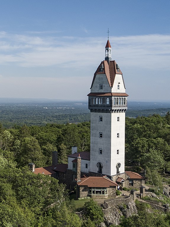
English: Heublein Tower was opened in 1914. It can be found at the top of Talcott Mountain State Park in Simsbury, Connecticut. On the left side of the the photograph you can see Hartford city skyline.
|
|||
Date | ||||
Source | Own work | |||
Author | Craig R. | |||
Other versions |
|
Camera location | 41° 49′ 36.15″ N, 72° 47′ 56.63″ W | View this and other nearby images on: OpenStreetMap | 41.826708; -72.799063 |
---|
This image was captured with a DJI Mavic Pro. Thank you!
Licensing
[edit]- You are free:
- to share – to copy, distribute and transmit the work
- to remix – to adapt the work
- Under the following conditions:
- attribution – You must give appropriate credit, provide a link to the license, and indicate if changes were made. You may do so in any reasonable manner, but not in any way that suggests the licensor endorses you or your use.
- share alike – If you remix, transform, or build upon the material, you must distribute your contributions under the same or compatible license as the original.
This image was uploaded as part of Wiki Loves Monuments 2018.
Afrikaans ∙ Alemannisch ∙ azərbaycanca ∙ Bahasa Indonesia ∙ Bahasa Melayu ∙ Bikol Central ∙ bosanski ∙ brezhoneg ∙ català ∙ čeština ∙ Cymraeg ∙ dansk ∙ davvisámegiella ∙ Deutsch ∙ eesti ∙ English ∙ español ∙ Esperanto ∙ euskara ∙ français ∙ Frysk ∙ Gaeilge ∙ galego ∙ hrvatski ∙ Ido ∙ italiano ∙ latviešu ∙ Lëtzebuergesch ∙ Malagasy ∙ magyar ∙ Malti ∙ Nederlands ∙ norsk ∙ norsk nynorsk ∙ norsk bokmål ∙ polski ∙ português ∙ português do Brasil ∙ română ∙ shqip ∙ sicilianu ∙ slovenčina ∙ slovenščina ∙ suomi ∙ svenska ∙ Tagalog ∙ Türkçe ∙ Yorùbá ∙ Zazaki ∙ Ελληνικά ∙ беларуская ∙ беларуская (тарашкевіца) ∙ български ∙ кыргызча ∙ македонски ∙ русский ∙ српски / srpski ∙ українська ∙ ქართული ∙ հայերեն ∙ नेपाली ∙ हिन्दी ∙ বাংলা ∙ മലയാളം ∙ ไทย ∙ 한국어 ∙ +/− |
File history
Click on a date/time to view the file as it appeared at that time.
Date/Time | Thumbnail | Dimensions | User | Comment | |
---|---|---|---|---|---|
current | 05:05, 3 August 2021 | 1,457 × 1,944 (1.08 MB) | Filetime (talk | contribs) | File:Heublein Tower on Talcott Mountain.jpg cropped 64 % horizontally, 13 % vertically using CropTool with precise mode. |
You cannot overwrite this file.
File usage on Commons
The following page uses this file:
File usage on other wikis
The following other wikis use this file:
- Usage on en.wikipedia.org
Metadata
This file contains additional information such as Exif metadata which may have been added by the digital camera, scanner, or software program used to create or digitize it. If the file has been modified from its original state, some details such as the timestamp may not fully reflect those of the original file. The timestamp is only as accurate as the clock in the camera, and it may be completely wrong.
Camera manufacturer | DJI |
---|---|
Camera model | FC220 |
Exposure time | 1/1,150 sec (0.0008695652173913) |
F-number | f/2.2 |
ISO speed rating | 100 |
Date and time of data generation | 16:49, 11 June 2017 |
Lens focal length | 4.7 mm |
Latitude | 41° 49′ 36.15″ N |
Longitude | 72° 47′ 56.63″ W |
Altitude | 29.4 meters above sea level |
Orientation | Normal |
Horizontal resolution | 300 dpi |
Vertical resolution | 300 dpi |
Software used | Adobe Photoshop CC 2018 (Macintosh) |
File change date and time | 20:15, 27 September 2018 |
Exposure Program | 58655 |
Exif version | 2.3 |
Date and time of digitizing | 16:49, 11 June 2017 |
APEX shutter speed | 10.167418 |
APEX aperture | 2.275007 |
APEX exposure bias | 1 |
Maximum land aperture | 2.27 APEX (f/2.2) |
Subject distance | 0 meters |
Metering mode | Spot |
Light source | Unknown |
Flash | Flash did not fire, No flash function |
Color space | Uncalibrated |
File source | Digital still camera |
Scene type | A directly photographed image |
Custom image processing | Normal process |
Exposure mode | Auto bracket |
White balance | Auto white balance |
Digital zoom ratio | 0 |
Focal length in 35 mm film | 26 mm |
Scene capture type | Standard |
Scene control | None |
Contrast | Normal |
Saturation | Normal |
Sharpness | Normal |
Subject distance range | Unknown |
GPS tag version | 0.0.3.2 |
Serial number of camera | 2014031100 |
Lens used | 26.3 mm f/2.2 |
Rating (out of 5) | 0 |
Date metadata was last modified | 16:15, 27 September 2018 |
Unique ID of original document | 4205B6938027F14F318567F5F4A86902 |
Structured data
Items portrayed in this file
depicts
41°49'36.149"N, 72°47'56.627"W
11 June 2017
0.00086956521739130434 second
2.2
4.7 millimetre
100
image/jpeg
- National Register of Historic Places with known IDs
- Extracted images
- CC-BY-SA-4.0
- Self-published work
- Images from Wiki Loves Monuments 2018
- Images from Wiki Loves Monuments 2018 in the United States
- Images from Wiki Loves Monuments 2018 in Connecticut
- Wiki Loves Monuments 2018 in the United States unreviewed
- Uploaded via Campaign:wlm-us
- United States photographs taken on 2017-06-11
- Taken with DJI FC220
- Pages with maps