File:Houston, Texas at Night.JPG
Jump to navigation
Jump to search

Size of this preview: 398 × 599 pixels. Other resolutions: 159 × 240 pixels | 319 × 480 pixels | 510 × 768 pixels | 680 × 1,024 pixels | 1,361 × 2,048 pixels | 2,829 × 4,256 pixels.
Original file (2,829 × 4,256 pixels, file size: 1.5 MB, MIME type: image/jpeg)
Captions
Captions
Add a one-line explanation of what this file represents
Summary[edit]
| Description |
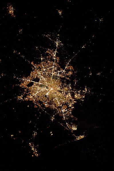
English: The image depicts the roughly 100 kilometre east-west extent of the Houston metropolitan area. Houston proper is at image centre, indicated by a “bull’s-eye” of elliptical white to orange-lighted beltways and brightly lit white free-ways radiating outwards from the central down-town area. Suburban and primarily residential urban land uses are indicated by both reddish-brown and grey-green lighted regions that reflect a higher proportion of tree cover and lower light density. Petroleum refineries along the Houston Ship Channel are identified by densely lit areas of golden yellow light. Rural and undeveloped land rings the metropolitan area, and Galveston Bay to the south-east (image lower right) provides access to the Gulf of Mexico. Both types of non-urban surface appear dark in the image. |
| Date | |
| Source | NASA Earth Observatory |
| Author | Image taken by the NASA Expedition 22 crew. |
Image acquired with a Nikon D3X digital camera fitted with an 800mm lens, and is provided by the ISS Crew Earth Observations experiment and Image Science & Analysis Laboratory, Johnson Space Center.
Licensing[edit]
| This file is in the public domain in the United States because it was solely created by NASA. NASA copyright policy states that "NASA material is not protected by copyright unless noted". (See Template:PD-USGov, NASA copyright policy page or JPL Image Use Policy.) | ||
 |
Warnings:
|
| Annotations | This image is annotated: View the annotations at Commons |
File history
Click on a date/time to view the file as it appeared at that time.
| Date/Time | Thumbnail | Dimensions | User | Comment | |
|---|---|---|---|---|---|
| current | 12:14, 22 March 2010 | | 2,829 × 4,256 (1.5 MB) | Originalwana (talk | contribs) | {{Information |Description={{en|1=The image depicts the roughly 100 kilometre east-west extent of the Houston metropolitan area. Houston proper is at image centre, indicated by a “bull’s-eye” of elliptical white to [[Orange (colo |
You cannot overwrite this file.
File usage on Commons
There are no pages that use this file.