File:Hurricane Floyd (1999).jpg
Jump to navigation
Jump to search
No higher resolution available.
Hurricane_Floyd_(1999).jpg (720 × 540 pixels, file size: 255 KB, MIME type: image/jpeg)
Captions
Captions
Add a one-line explanation of what this file represents
Summary[edit]
.jpg&action=edit§ion=1)
| Description |
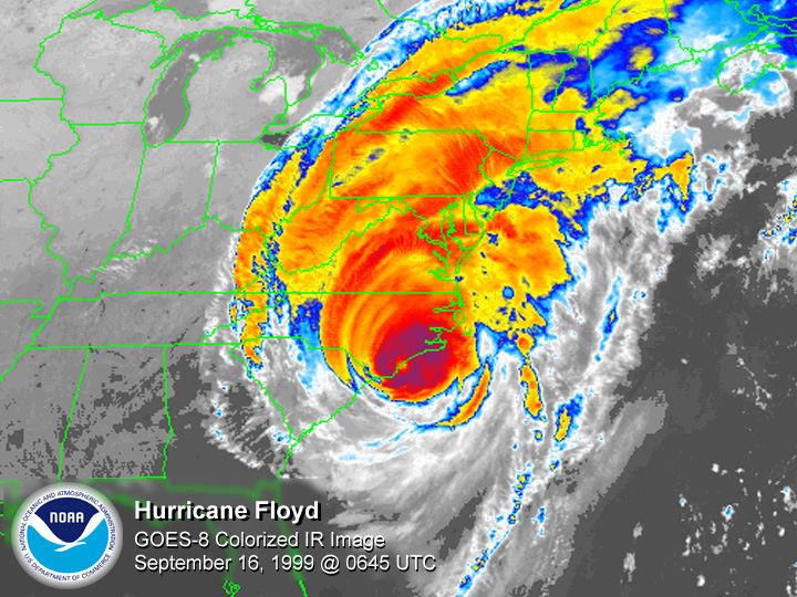
English: GOES 8 satellite colored infrared image of Hurricane Floyd making landfall at Cape Fear, North Carolina |
| Date | |
| Source | National Climatic Data Center |
| Author | National Oceanic and Atmospheric Administration |
Licensing[edit]
.jpg&action=edit§ion=2)
- The NOAA emblem is the property of the U.S. Government and a trademark of the United States Department of Commerce.
This image is in the public domain because it contains materials that originally came from the U.S. National Oceanic and Atmospheric Administration, taken or made as part of an employee's official duties.
|
File history
Click on a date/time to view the file as it appeared at that time.
| Date/Time | Thumbnail | Dimensions | User | Comment | |
|---|---|---|---|---|---|
| current | 21:06, 26 January 2006 | | 720 × 540 (255 KB) | Hurricanehink (talk | contribs) | From http://www1.ncdc.noaa.gov/pub/data/images/hurr-floyd-19990916-0645utc-g84kmir.jpg, this image shows Hurricane Floyd at its Cape Fear, North Carolina landfall on September 16, 1999. {{PD-USGov-NOAA}} {{NOAA logo}} [[Category:Atlantic hurricanes|Flo |
You cannot overwrite this file.
File usage on Commons
There are no pages that use this file.
File usage on other wikis
The following other wikis use this file:
- Usage on en.wikipedia.org
- Usage on es.wikipedia.org
- Usage on fr.wikipedia.org
.jpg&oldid=505347608)