File:IMCRA 4.0 Norfolk Island Province.png
Jump to navigation
Jump to search

Size of this preview: 800 × 510 pixels. Other resolutions: 320 × 204 pixels | 640 × 408 pixels | 1,024 × 653 pixels | 1,278 × 815 pixels.
Original file (1,278 × 815 pixels, file size: 44 KB, MIME type: image/png)
Captions
Captions
Add a one-line explanation of what this file represents
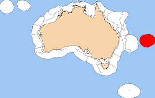
| Description | This is a map of Norfolk Island Province, a provincial bioregion under the Integrated Marine and Coastal Biogeographic Regionalisation of Australia (IMCRA) Version 4.0. Australia is displayed in brown, and open ocean not covered by IMCRA in blue. Norfolk Island Province is displayed in red, with the remaining area covered by the IMCRA regionalisation in white. | ||
| Date | |||
| Source | Own work | ||
| Author | Hesperian | ||
| Permission (Reusing this file) |
I, the copyright holder of this work, hereby publish it under the following licenses:
This file is licensed under the Creative Commons Attribution-Share Alike 4.0 International, 3.0 Unported, 2.5 Generic, 2.0 Generic and 1.0 Generic license.
You may select the license of your choice. |


|
This biogeographical map image could be re-created using vector graphics as an SVG file. This has several advantages; see Commons:Media for cleanup for more information. If an SVG form of this image is available, please upload it and afterwards replace this template with
{{vector version available|new image name}}.
It is recommended to name the SVG file “IMCRA 4.0 Norfolk Island Province.svg”—then the template Vector version available (or Vva) does not need the new image name parameter. |
File history
Click on a date/time to view the file as it appeared at that time.
| Date/Time | Thumbnail | Dimensions | User | Comment | |
|---|---|---|---|---|---|
| current | 05:53, 25 February 2008 | | 1,278 × 815 (44 KB) | Hesperian (talk | contribs) | {{Information |Description=This is a map of '''Norfolk Island Province''', a provincial bioregion under the Integrated Marine and Coastal Biogeographic Regionalisation of Australia (IMCRA) Version 4.0. Australia is displayed in brown, and open oce |
You cannot overwrite this file.
File usage on Commons
There are no pages that use this file.
File usage on other wikis
The following other wikis use this file:
- Usage on pl.wikipedia.org