File:Iceberg B-15 2018.png
Jump to navigation
Jump to search
No higher resolution available.
Iceberg_B-15_2018.png (720 × 480 pixels, file size: 279 KB, MIME type: image/png)
Captions
Captions
Route map of Iceberg B-15
Summary[edit]
| Description |
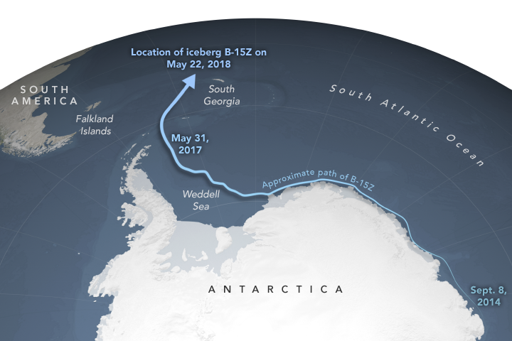
English: Route map of Iceberg B-15Z in Antarctica from 2000 to 2018. The last traceable piece of Iceberg B-15. |
| Date | |
| Source | https://earthsky.org/earth/iceberg-b15z-antarctica-ross-ice-shelf |
| Author | NASA |
Licensing[edit]
| This file is in the public domain in the United States because it was solely created by NASA. NASA copyright policy states that "NASA material is not protected by copyright unless noted". (See Template:PD-USGov, NASA copyright policy page or JPL Image Use Policy.) | ||
 |
Warnings:
|
File history
Click on a date/time to view the file as it appeared at that time.
| Date/Time | Thumbnail | Dimensions | User | Comment | |
|---|---|---|---|---|---|
| current | 00:00, 23 July 2019 | | 720 × 480 (279 KB) | GreenC (talk | contribs) | User created page with UploadWizard |
You cannot overwrite this file.
File usage on Commons
The following 2 pages use this file:
File usage on other wikis
The following other wikis use this file:
- Usage on en.wikipedia.org
- Usage on fa.wikipedia.org
- Usage on hy.wikipedia.org
- Usage on id.wikipedia.org
- Usage on ja.wikipedia.org
- Usage on th.wikipedia.org
- Usage on www.wikidata.org