File:Imperial Federation, map of the world showing the extent of the British Empire in 1886.jpg
Jump to navigation
Jump to search
Size of this preview: 798 × 600 pixels. Other resolutions: 319 × 240 pixels | 639 × 480 pixels | 1,022 × 768 pixels | 1,128 × 848 pixels.
Original file (1,128 × 848 pixels, file size: 376 KB, MIME type: image/jpeg)
Captions
Captions
Add a one-line explanation of what this file represents
| Description |
English: Zoom into this map at http://maps.bpl.org.
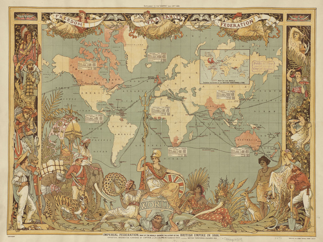
Author: Colomb, J. C. R. Publisher: MacClure & Co. Date: 1886. Location: Great Britain Scale: Scale not given ; Call Number: G5730 1886.C6 Everything about the design of this elaborately decorated world map glorifies the late-19th-century British Empire. Cartographically it used a Mercator projection centered on the Greenwich Prime Meridian, placing Great Britain just above the map's central focal point. The Greenwich Prime Meridian (near London) was adopted as the international standard in October 1884. The British Isles, as well as all of the British colonies spreading out to the east and the west, were highlighted with red, while other geographical areas were left blank with only a minimum number of place names. In addition, an inset box was placed near each of the major colonies, listing statistics about geographical area, population, and trade. The words "Freedom, Fraternity, Federation," suggesting a peaceful co-existence within the British Empire, were prominently placed along the map's top margin, but the remainder of the map's illustrations imply "colonialism." At the bottom center Britannia is seated on top of the world ruling over her subjects, represented by a variety of animals and costumed figures. India, quickly identified by an elephant and a tiger, appears in the lower left corner, while Australia, including a kangaroo and a sheep, is shown in the lower right. Using the Mercator projection in constructing this thematic map may have not been the most appropriate choice because it greatly exaggerates the size of Canada. However, since this projection is best used for navigational purposes, it was a reasonable choice. Considering the British Empire thrived on ocean-going transportation, the use of this projection would have provided a familiar image for the British public. |
||
| Date | |||
| Source | Flickr: Imperial Federation, map of the world showing the extent of the British Empire in 1886 | ||
| Author | http://maps.bpl.org | ||
| Permission (Reusing this file) |
This file is licensed under the Creative Commons Attribution 2.0 Generic license.
|
File history
Click on a date/time to view the file as it appeared at that time.
| Date/Time | Thumbnail | Dimensions | User | Comment | |
|---|---|---|---|---|---|
| current | 14:51, 7 December 2011 | | 1,128 × 848 (376 KB) | AnonMoos (talk | contribs) | losslessly cropping |
| 05:38, 20 July 2011 |  | 1,200 × 898 (409 KB) | Flickr upload bot (talk | contribs) | Uploaded from http://flickr.com/photo/24528911@N05/2710800068 using Flickr upload bot |
You cannot overwrite this file.
File usage on Commons
There are no pages that use this file.
File usage on other wikis
The following other wikis use this file:
- Usage on el.wikipedia.org