File:Indiana Monument Antietam 085333pr.jpg
Original file (362 × 605 pixels, file size: 29 KB, MIME type: image/jpeg)
Captions
Captions
Summary
[edit]
Transwiki approved by: w:en:User:Dmcdevit
This image was copied from wikipedia:en. The original description was:
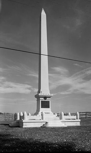
This is a cropped version of a photo made in 1989 by w:en:Jack E. Boucher of the Historic American Buildings Survey of the monument at the w:en:Antietam National Battlefield commemorating the 7th, 14th, 19th and 27th Indiana infantry regiments and the w:en:3rd Regiment Indiana Cavalry (East Wing). The "cornfield" is in background. Monument erected in 1910. The photo is no. 23 of a series of 110.
Antietam National Battlefield, Sharpsburg vicinity, Washington County, MD
CALL NUMBER: HABS MD,22-SHARP.V,9-23
REPRODUCTION NUMBER: See Call Number
MEDIUM: Photo(s): 110 (5 x 7 in.) Color Transparencies: 1
DATE: Documentation compiled after 1933.
CREATOR: Historic American Buildings Survey, creator
RELATED NAME(S): Mansfield, Maj Gen. Joseph K. F. Stetson, Lt Col. John L. Starke, Brig Gen. William E. Anderson Richardson, Israel McKinley, Sgt. William Boucher, Jack E., photographer Boucher, Jack E., photographer
NOTE: Survey number HABS MD-934
SUBJECTS: MARYLAND--Washington County--Sharpsburg vicinity war (Civil War) battlefields
OTHER TITLE: Antietam National Battlefield
COLLECTION: Historic American Buildings Survey (Library of Congress)
REPOSITORY: Library of Congress, Prints and Photograph Division, Washington, D.C. 20540 USA
DIGID: [1]
CONTENTS: Photograph caption(s):
23. INDIANA STATE (7TH, 14TH, 19TH & 27TH INFANTRY & 30TH CAVALRY [sic, unit was 3rd Cav.]) MONUMENT, NORTH SIDE OF CORNFIELD AVENUE AT INTERSECTION OF OLD HAGERSTOWN PIKE HABS MD,22-SHARP.V,9-23
CARD #: MD1073
Licensing
[edit]

|
This file comes from the Historic American Buildings Survey (HABS), Historic American Engineering Record (HAER) or Historic American Landscapes Survey (HALS). These are programs of the National Park Service established for the purpose of documenting historic places. Records consist of measured drawings, archival photographs, and written reports.
This tag does not indicate the copyright status of the attached work. A normal copyright tag is still required. See Commons:Licensing. |
| This image or media file contains material based on a work of a National Park Service employee, created as part of that person's official duties. As a work of the U.S. federal government, such work is in the public domain in the United States. See the NPS website and NPS copyright policy for more information. |
File history
Click on a date/time to view the file as it appeared at that time.
| Date/Time | Thumbnail | Dimensions | User | Comment | |
|---|---|---|---|---|---|
| current | 16:15, 13 September 2007 | | 362 × 605 (29 KB) | BetacommandBot (talk | contribs) | Transwiki approved by: w:en:User:Dmcdevit This image was copied from wikipedia:en. The original description was: This is a cropped version of a photo made in 1989 by w:en:Jack E. Boucher of the Historic American Buildings Survey of the monument |
You cannot overwrite this file.
File usage on Commons
There are no pages that use this file.
File usage on other wikis
The following other wikis use this file:
- Usage on en.wikipedia.org
- Usage on fr.wikipedia.org