File:Intercommunalités Seine-Maritime 2019.svg
Jump to navigation
Jump to search

Size of this PNG preview of this SVG file: 744 × 600 pixels. Other resolutions: 298 × 240 pixels | 595 × 480 pixels | 953 × 768 pixels | 1,270 × 1,024 pixels | 2,540 × 2,048 pixels | 852 × 687 pixels.
Original file (SVG file, nominally 852 × 687 pixels, file size: 479 KB)
Captions
Captions
Add a one-line explanation of what this file represents
Summary[edit]
| Description |
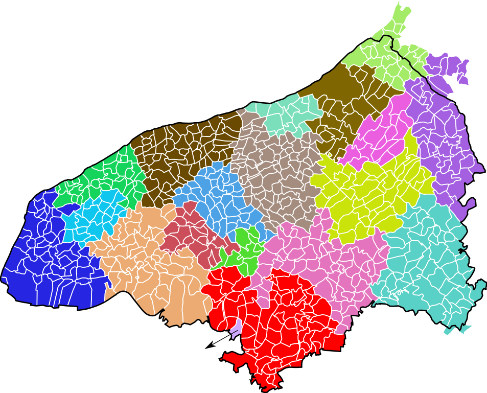
Français : Carte des intercommunalités du département de la Seine-Maritime, France. Composition au 1er janvier 2019 :
English: Map of groups of communes in Seine-Maritime department, France. Composition on 1st January 2019. |
| Date | |
| Source | Own work |
| Author | Pymouss |
| Permission (Reusing this file) |
Based on GEOFLA® 2016 v2.2 Communes France Métropolitaine, a work of Institut géographique national, licensed under the Licence Ouverte. |
Licensing[edit]
I, the copyright holder of this work, hereby publish it under the following license:
This file is licensed under the Creative Commons Attribution 4.0 International license.
- You are free:
- to share – to copy, distribute and transmit the work
- to remix – to adapt the work
- Under the following conditions:
- attribution – You must give appropriate credit, provide a link to the license, and indicate if changes were made. You may do so in any reasonable manner, but not in any way that suggests the licensor endorses you or your use.
File history
Click on a date/time to view the file as it appeared at that time.
| Date/Time | Thumbnail | Dimensions | User | Comment | |
|---|---|---|---|---|---|
| current | 18:18, 17 July 2019 | | 852 × 687 (479 KB) | Pymouss (talk | contribs) | Update 2019/1/1 (fixing errors) |
| 16:03, 2 January 2019 |  | 744 × 600 (436 KB) | Rustresh76 (talk | contribs) | Modification de la Carte | |
| 17:47, 26 February 2017 |  | 852 × 687 (476 KB) | Pymouss (talk | contribs) | {{Information |description={{fr|1=Carte des intercommunalités du département de la Seine-Maritime, France. Composition au 1{{er}} janvier 2017 : *{{legend|#ff0000|fr:Métropole Rouen-Normandie}} *{{legend|#2525e2|[[:fr:Communauté de l'agglomé... |
You cannot overwrite this file.
File usage on Commons
The following 23 pages use this file:
- User:J budissin/Uploads/BiH/2019 January 1-10
- User:J budissin/Uploads/BiH/2019 July 11-20
- File:Intercommunalités Seine-Maritime 2017.svg (file redirect)
- File:Localisation CA Caux vallée de Seine dans la Seine-Maritime, France.svg
- File:Localisation CA Communauté de l'agglomération havraise dans la Seine-Maritime, France.svg
- File:Localisation CA de Fécamp Caux Littoral dans la Seine-Maritime, France.svg
- File:Localisation CA de la Région Dieppoise dans la Seine-Maritime, France.svg
- File:Localisation CC Caux-Austreberthe dans la Seine-Maritime, France.svg
- File:Localisation CC Caux Estuaire dans la Seine-Maritime, France.svg
- File:Localisation CC Communauté Bray-Eawy dans la Seine-Maritime, France.svg
- File:Localisation CC Inter-Caux-Vexin dans la Seine-Maritime, France.svg
- File:Localisation CC Plateau de Caux-Doudeville-Yerville dans la Seine-Maritime, France.svg
- File:Localisation CC Terroir de Caux dans la Seine-Maritime, France.svg
- File:Localisation CC de Londinières dans la Seine-Maritime, France.svg
- File:Localisation CC de la Côte d'Albâtre dans la Seine-Maritime, France.svg
- File:Localisation CC de la campagne de Caux dans la Seine-Maritime, France.svg
- File:Localisation CC de la région d'Yvetot dans la Seine-Maritime, France.svg
- File:Localisation CC des Falaises du Talou dans la Seine-Maritime, France.svg
- File:Localisation CC des Quatre Rivières dans la Seine-Maritime, France.svg
- File:Localisation CC des Villes Sœurs dans la Seine-Maritime, France.svg
- File:Localisation CC du canton de Criquetot-l'Esneval dans la Seine-Maritime, France.svg
- File:Localisation CC interrégionale Aumale - Blangy-sur-Bresle dans la Seine-Maritime, France.svg
- File:Localisation Métropole Rouen-Normandie dans la Seine-Maritime, France.svg
File usage on other wikis
The following other wikis use this file:
- Usage on fr.wikipedia.org
- Usage on fr.wikivoyage.org