File:Intermarium.png
Jump to navigation
Jump to search

Size of this preview: 800 × 595 pixels. Other resolutions: 320 × 238 pixels | 640 × 476 pixels | 997 × 742 pixels.
Original file (997 × 742 pixels, file size: 128 KB, MIME type: image/png)
Captions
Captions
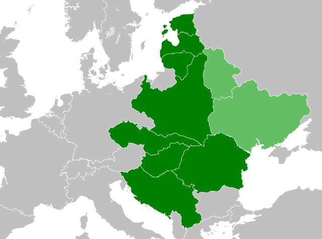
Map of the proposed Intermarium

|
This map image could be re-created using vector graphics as an SVG file. This has several advantages; see Commons:Media for cleanup for more information. If an SVG form of this image is available, please upload it and afterwards replace this template with
{{vector version available|new image name}}.
It is recommended to name the SVG file “Intermarium.svg”—then the template Vector version available (or Vva) does not need the new image name parameter. |
Summary[edit]
| Description |
English: The Intermarium (Polish: Międzymorze) was a proposed federation in Central Europe by Józef Piłsudski. Lands shown in light green were incorporated into the Soviet Union in 1922. |
| Date | |
| Source | Own work |
| Author | GalaxMaps |
Licensing[edit]
I, the copyright holder of this work, hereby publish it under the following license:
This file is licensed under the Creative Commons Attribution-Share Alike 4.0 International license.
- You are free:
- to share – to copy, distribute and transmit the work
- to remix – to adapt the work
- Under the following conditions:
- attribution – You must give appropriate credit, provide a link to the license, and indicate if changes were made. You may do so in any reasonable manner, but not in any way that suggests the licensor endorses you or your use.
- share alike – If you remix, transform, or build upon the material, you must distribute your contributions under the same or compatible license as the original.
File history
Click on a date/time to view the file as it appeared at that time.
| Date/Time | Thumbnail | Dimensions | User | Comment | |
|---|---|---|---|---|---|
| current | 16:24, 11 April 2021 | | 997 × 742 (128 KB) | GalaxMaps (talk | contribs) | crimea |
| 17:57, 6 July 2020 |  | 1,280 × 1,131 (272 KB) | GalaxMaps (talk | contribs) | . | |
| 17:54, 6 July 2020 |  | 1,280 × 1,131 (253 KB) | GalaxMaps (talk | contribs) | Reverted to version as of 17:54, 6 July 2020 (UTC) | |
| 17:54, 6 July 2020 |  | 997 × 742 (128 KB) | GalaxMaps (talk | contribs) | Reverted to version as of 13:52, 6 July 2020 (UTC) | |
| 17:54, 6 July 2020 |  | 1,280 × 1,131 (253 KB) | GalaxMaps (talk | contribs) | . | |
| 13:52, 6 July 2020 |  | 997 × 742 (128 KB) | GalaxMaps (talk | contribs) | Uploaded own work with UploadWizard |
You cannot overwrite this file.
File usage on Commons
The following page uses this file:
File usage on other wikis
The following other wikis use this file:
- Usage on ar.wikipedia.org
- Usage on cs.wikipedia.org
- Usage on el.wikipedia.org
- Usage on en.wikipedia.org
- Usage on es.wikipedia.org
- Usage on fi.wikipedia.org
- Usage on hu.wikipedia.org
- Usage on it.wikipedia.org
- Usage on ko.wikipedia.org
- Usage on lt.wikipedia.org
- Usage on lv.wikipedia.org
- Usage on pl.wikipedia.org
- Usage on ro.wikipedia.org
- Usage on sl.wikipedia.org
- Usage on sr.wikipedia.org
- Usage on tr.wikipedia.org