File:Islandia (Abraham Ortelius).jpg
Jump to navigation
Jump to search

Size of this preview: 800 × 600 pixels. Other resolutions: 320 × 240 pixels | 640 × 480 pixels | 1,024 × 768 pixels | 1,280 × 960 pixels | 2,592 × 1,944 pixels.
Original file (2,592 × 1,944 pixels, file size: 1.11 MB, MIME type: image/jpeg)
Captions
Captions
Add a one-line explanation of what this file represents
Summary[edit]
| Description |
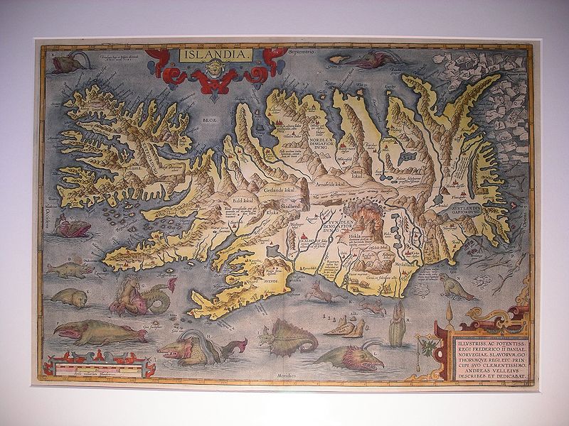
English: This map showing Iceland is a one of the finest maps created by the cartographer Abraham Ortelius in his legendary atlas "Theatrum Orbis Terrarum". The map was created by Ortelius in 1585 (copper engraving) and printed 4150 times in several editions. According to experts (www.orteliusmaps.com) only about 440 examples are left. This map is from the italian edition of 1608/1612. The island of Iceland is shown at large scale and with a rather correct form. The map is very famous for the most fantastic collection of monsters to be seen on one engraving and for the erupting volcano - Mt. Hekla. Polar bears on icebergs can be seen at top right.
Deutsch: Diese Karte von Island ist eine der schönsten und bekanntesten Karten, welche der Kartograph Abraham Ortelius in seinem Atlas "Theatrum Orbis Terrarum" erschaffen hat. Die Kupferplatte für diese Karte wurde im Jahre 1585 angefertigt. Gemäss Experten (www.orteliusmaps.com) wurden davon 4150 Exemplare in mehreren Ausgaben gedruckt. Dieses Exemplar stammt aus der italienischen Ausgabe aus den Jahren 1608/1612. Die Karte gilt als herausragendes Beispiel kartographischer Kunst zur Zeit der Renaissance und ist bei Sammlern wegen der grossen Anzahl furchterregender Seemonster und des ausbrechenden Vulkans Hekla sehr begehrt. Rechts oben tummeln sich Eisbären auf dem Treibeis und weiter unten ist Treibholz zu erkennen. |
|||||||||||||||||||||||
| Date | 1585, edition 1608/1612 | |||||||||||||||||||||||
| Source | Privatbesitz / personal ownership | |||||||||||||||||||||||
| Author |
|
|||||||||||||||||||||||
| Other versions |
|
|||||||||||||||||||||||


.jpg&action=edit§ion=1)
Licensing[edit]
.jpg&action=edit§ion=2)
|
This work is in the public domain in its country of origin and other countries and areas where the copyright term is the author's life plus 100 years or fewer. | |
| This file has been identified as being free of known restrictions under copyright law, including all related and neighboring rights. | |
| Annotations | This image is annotated: View the annotations at Commons |
.jpg)
File history
Click on a date/time to view the file as it appeared at that time.
| Date/Time | Thumbnail | Dimensions | User | Comment | |
|---|---|---|---|---|---|
| current | 20:53, 28 February 2009 | | 2,592 × 1,944 (1.11 MB) | Altiplano (talk | contribs) | {{Information |Description={{en|1=This map showing Iceland is a one of the finest maps created by the cartographer Abraham Ortelius in his legendary atlas "Theatrum Orbis Terrarum". The map was created by Ortelius in 1585 (copper engraving) and printed 41 |
You cannot overwrite this file.
File usage on Commons
The following page uses this file:
_Detail_from_map_of_Iceland_1585.jpg)
File usage on other wikis
The following other wikis use this file:
- Usage on el.wikipedia.org
.jpg&oldid=860604387)