File:Italy c 1810.png
Jump to navigation
Jump to search
Size of this preview: 413 × 599 pixels. Other resolutions: 165 × 240 pixels | 331 × 480 pixels | 529 × 768 pixels | 1,251 × 1,814 pixels.
Original file (1,251 × 1,814 pixels, file size: 90 KB, MIME type: image/png)
Captions
Captions
Add a one-line explanation of what this file represents
Summary[edit]
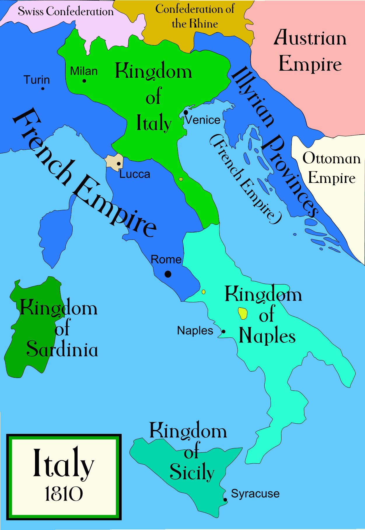
Political map of Italy in the years around 1810, during the Napoleonic era, created by MapMaster. This is a companion map to Image:Italy 1796.png and Image:Italy 1494_v2.png. An SVG version of this map (with Slovenian labels) can be found at Image:Italija_1810_Slovenscina.svg.
Spanish version: File:Italy c 1810-es.png, uploaded by Aibdescalzo

|
This historical map image could be re-created using vector graphics as an SVG file. This has several advantages; see Commons:Media for cleanup for more information. If an SVG form of this image is available, please upload it and afterwards replace this template with
{{vector version available|new image name}}.
It is recommended to name the SVG file “Italy c 1810.svg”—then the template Vector version available (or Vva) does not need the new image name parameter. |
References[edit]
- Bjorklund, Oddvar; Holmboe, Haakon; Rohr, Anders (1970) Historical Atlas of the World, Barnes & Noble, NY, SBN: 389-00253-4.
- Other maps, including Image:1french-empire1811.jpg from the 1912 Cambridge Modern History Atlas.
Licensing[edit]
I, the copyright holder of this work, hereby publish it under the following licenses:

|
Permission is granted to copy, distribute and/or modify this document under the terms of the GNU Free Documentation License, Version 1.2 or any later version published by the Free Software Foundation; with no Invariant Sections, no Front-Cover Texts, and no Back-Cover Texts. A copy of the license is included in the section entitled GNU Free Documentation License. |
| This file is licensed under the Creative Commons Attribution-Share Alike 3.0 Unported license. | ||
| ||
| This licensing tag was added to this file as part of the GFDL licensing update. |
You may select the license of your choice.
derivative works[edit]
Derivative works of this file:
[]
-
 Arabic
 -
 English
 -
 Spanish
 -
 Korean


File history
Click on a date/time to view the file as it appeared at that time.
| Date/Time | Thumbnail | Dimensions | User | Comment | |
|---|---|---|---|---|---|
| current | 01:32, 21 April 2009 | | 1,251 × 1,814 (90 KB) | Capmo (talk | contribs) | pallette reduction to 64 colours |
| 04:01, 19 October 2006 |  | 1,251 × 1,814 (385 KB) | MapMaster (talk | contribs) | Further improvements to bring it into line with Image:Italy 1796.png | |
| 12:41, 13 October 2006 |  | 1,251 × 1,814 (403 KB) | MapMaster (talk | contribs) | Map was slightly improved. | |
| 12:00, 13 October 2006 |  | 1,265 × 1,816 (402 KB) | MapMaster (talk | contribs) | Political map of Italy in the years around 1810, during the Napoleonic era, created by MapMaster. |
You cannot overwrite this file.
File usage on Commons
The following 35 pages use this file:
- Atlas of Croatia
- Atlas of Italy
- Atlas of Slovenia
- Atlas of Yugoslavia
- Illyria and Illyrians
- Maps of Italy
- Maps of the Italian Risorgimento
- User:MapMaster
- File:Balkans Animation 1800-2008.gif
- File:Duchy of Carinthia-1000 AD.svg
- File:Italia 1000 AD-Ido.svg
- File:Italy 1000 AD-de.svg
- File:Italy 1000 AD-el.png
- File:Italy 1000 AD-es.svg
- File:Italy 1000 AD-he.svg
- File:Italy 1000 AD-hu.svg
- File:Italy 1000 AD-ru.svg
- File:Italy 1000 AD.svg
- File:Italy 1494 AD-ar.png
- File:Italy 1494 AD-hu.svg
- File:Italy 1494 AD.png
- File:Italy 1494 el.png
- File:Italy 1796 AD-el.png
- File:Italy 1796 AD.png
- File:Italy 1796 heb.jpg
- File:Italy and Illyria 1084 AD-hu.svg
- File:Italy and Illyria 1084 AD-it.svg
- File:Italy and Illyria 1084 AD-ru.svg
- File:Italy and Illyria 1084 AD.svg
- File:Italy c 1810-es.png
- File:Italy c 1810-ko.png
- File:Italy c 1810.png
- File:Italy c 1810 ar.jpg
- Template:Other versions/Italy 1810 AD
- Category:Napoleonic Kingdom of Naples
File usage on other wikis
The following other wikis use this file:
- Usage on an.wikipedia.org
- Usage on be.wikipedia.org
- Usage on br.wikipedia.org
- Usage on ca.wikipedia.org
- Usage on ceb.wikipedia.org
- Usage on cs.wikipedia.org
- Usage on da.wikipedia.org
- Usage on de.wikipedia.org
- Usage on en.wikipedia.org
- Usage on eo.wikipedia.org
- Usage on es.wikipedia.org
- Usage on et.wikipedia.org
- Usage on fa.wikipedia.org
- Usage on fr.wikipedia.org
- Usage on he.wikipedia.org
- Usage on hi.wikipedia.org
- Usage on hr.wikipedia.org
- Usage on hu.wikipedia.org
- Usage on id.wikipedia.org
- Usage on is.wikipedia.org
- Usage on it.wikipedia.org
- Usage on ja.wikipedia.org
View more global usage of this file.