File:Józefów - panorama zalewu (2).jpg
Jump to navigation
Jump to search

Size of this preview: 800 × 128 pixels. Other resolutions: 320 × 51 pixels | 640 × 102 pixels | 1,024 × 164 pixels | 1,280 × 205 pixels | 2,560 × 410 pixels | 13,198 × 2,112 pixels.
Original file (13,198 × 2,112 pixels, file size: 16.44 MB, MIME type: image/jpeg)
Captions
Captions
Add a one-line explanation of what this file represents
Summary[edit]
.jpg&action=edit§ion=1)
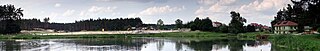
| Description | Panorama plaży nad zalewem w Józefowie |
| Date | |
| Source | Own work |
| Author | Zbigniew.czernik |
| Camera location | | View this and other nearby images on: OpenStreetMap |
|---|
.jpg¶ms=050.481823_N_0023.037920_E_globe:Earth_type:camera__&language=en)
Licensing[edit]
.jpg&action=edit§ion=2)
This file is licensed under the Creative Commons Attribution 3.0 Unported license.
Attribution: Zbigniew Czernik / Wikimedia PL
- You are free:
- to share – to copy, distribute and transmit the work
- to remix – to adapt the work
- Under the following conditions:
- attribution – You must give appropriate credit, provide a link to the license, and indicate if changes were made. You may do so in any reasonable manner, but not in any way that suggests the licensor endorses you or your use.
This photo was taken during Wikiexpedition 2014 set up by Wikimedia Polska Association. You can see all photographs in category Wikiekspedycja 2014.
|
File history
Click on a date/time to view the file as it appeared at that time.
| Date/Time | Thumbnail | Dimensions | User | Comment | |
|---|---|---|---|---|---|
| current | 22:49, 17 August 2014 | 13,198 × 2,112 (16.44 MB) | Gordon2007 (talk | contribs) | VicuñaUploader 1.20 |
You cannot overwrite this file.
File usage on Commons
The following page uses this file:
File usage on other wikis
The following other wikis use this file:
- Usage on en.wikivoyage.org
- Usage on eo.wikipedia.org
- Usage on pt.wikipedia.org
- Usage on www.wikidata.org
.jpg&oldid=477424225)