File:Jefferson Davis Park 4-4 (28233557739).jpg

Original file (4,752 × 3,168 pixels, file size: 12.46 MB, MIME type: image/jpeg)
Captions
Captions
Summary
[edit].jpg&action=edit§ion=1)
| Description |
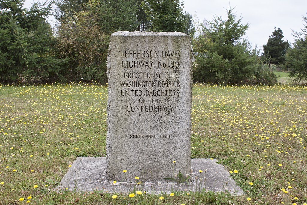
24024 NW Maplecrest Road Ridgefield Washington scvpacnw.wordpress.com/jefferson-davis-park/ History of the Jefferson Davis Park On May 23, 1941, at the Washington Division UDC Convention, Mrs. Charles E. Bolling, President-General of the UDC read a telegram stating, “Congratulations upon completion Jefferson Davis Highway Marker and Greetings.” Signed Eleanor Roosevelt. The concept of a Jefferson Davis Memorial Highway was presented and adopted at the UDC general convention in 1913. The plan then was to have a highway that would begin in Virginia on the banks of the Potomac and pass through the states of Mississippi, Tennessee and into Kentucky to Davis’ birthplace. The highway continued to move west through Louisiana, Texas, New Mexico, Arizona and into California where it stopped at San Diego. The members of the UDC Washington Division wished to have the highway extended into this state. From research done in the archives of the University of Washington in Seattle, Mrs. May Avery Wilkins found many ties between Jefferson Davis and Washington Territory. While serving in the Federal Government, Jefferson Davis pushed for westward expansion, adding forts, arsenals and other public provisions. He was one of seven appointed as a special committee to decide the expenditure of the inheritance from James Smithson. He pushed for using the money for an institution to benefit science and diffuse knowledge and new information throughout the country. Today we know this as the Smithsonian Institution. President Franklin Pierce appointed Mr. Davis Secretary of War in 1853. During that time, he increased the United States Army coastal defenses, increased the military wages, and gained a new pension system for military widows. He upgraded the military weapons to percussion rifles. He directed three surveys for Trans-Continental railroad to the Pacific. He appointed Isaac Stevens, the first Governor of Washington, to head the northern route survey who requested George B. McClellan to be Principal officer on the survey team. Davis made it mandatory for all surveys be done by the new geodetic method which provided a higher degree of accuracy by taking the curvature of the earth into account. Secretary Davis directed McClellan to construction a military road from Walla-Walla to Steilacomb, Puget Sound. Then a road was constructed from Fort Steilacoom to Bellingham Bay to the new army post. Making roads to move the military was top priority for Secretary of War Davis. Many of the roads and highways today throughout America are descendants of roads championed by Jefferson Davis. To provide the best route for a transcontinental railroad, Davis had James Gadsden buy a region from Mexico that became a part of Arizona and New Mexico States. Davis spoke widely for harmony between the Union. He proclaimed himself a dedicated Unionist opposing secession while dedicated to the principles of democracy and state rights. He worked to block the northern drive to control the country. He left the US Senate to join the Confederate Army when Mississippi seceded from the Union but was elected president of the newly formed Southern Confederacy. He sent a peace commission to President Lincoln who refused to meet with them. The Jefferson Davis Memorial Highway 99 and markers are to honor all of Mr. Davis’ services in the development of this country. In the late 1990s the Highway marker originally placed in Vancouver in 1939 was quietly removed by the City Manager due to the insistence of an “offended” City Councilman. In 2001, members of the Seattle Chapter of the UDC and the Portland SCV Camp learned what had happened, and together with our good friends of the Olympia Chapter of the Sons of Union Veterans of the Civil War, we spent more than a year fighting the City of Vancouver to reinstall the marker. Instead, after culminating into a public town-hall meeting where the citizens of Vancouver, with the full support of the Director of the Clark County Historical Museum, decided that the best thing for the marker would be for it to be placed at the Historical Museum. The City Council approved the good citizens’ opinion with a formal vote, and the marker finally found a home outside the Museum on the corner of Main & 16th. But it was no fairy-tale ending. Five years later, a new Director assumed command of the Clark County Historical Museum and worked tirelessly to have it removed from the grounds by any means possible. With protests from the UDC and SCV, the marker was moved “temporarily” in the fall of 2006, with the sanction of the Clark County Historical Commission, allegedly to keep it safe during the construction of a new handicapped-accessible entrance. We knew it would never go back, and sure enough we had another fight on our hands. We took our fight to the Clark County Historical Commission, who was the body that had to approve the “temporary” move of the marker in the first place. After some debate, the majority of the Commission sided with our Cause, and one of the Commission members said that she would see us at the next City Council meeting to support us in getting the marker placed back at the Museum, and may be even back at its original location at the Covington Cabin. At the City Council meeting The Mayor of Vancouver came down rather swiftly and severely stating that the marker was in fact considered a “gift” that the City no longer wanted, that the marker would never again sit on City property, and that the issue of the marker would/should not come before him again… Neither the history of Jefferson Davis in the Pacific-Northwest or the historical marker itself means anything to the local officials or the Director of the Historical Museum. Faced with this decision, there was no choice but for us to procure a piece of land of our own, specifically for the placement of the Jefferson Davis Highway marker where it could remain permanently. This project is not just saving history, which is phenomenal enough in itself, but we are making history! Today, Jefferson Davis Park is the Northwests shining tribute to President Davis. It now houses both the Vancouver and Blaine, Washington, Hwy 99 Markers, safely preserving them for future generations. |
| Date | |
| Source | Jefferson Davis Park 4/4 |
| Author | raschau from Evansville, IN |
| Camera location | | View this and other nearby images on: OpenStreetMap |
|---|
.jpg¶ms=045.794258_N_-122.677627_E_globe:Earth_type:camera_source:Flickr_&language=en)
Licensing
[edit].jpg&action=edit§ion=2)
- You are free:
- to share – to copy, distribute and transmit the work
- to remix – to adapt the work
- Under the following conditions:
- attribution – You must give appropriate credit, provide a link to the license, and indicate if changes were made. You may do so in any reasonable manner, but not in any way that suggests the licensor endorses you or your use.
| This image was originally posted to Flickr by raschau at https://flickr.com/photos/144021971@N04/28233557739 (archive). It was reviewed on 4 February 2018 by FlickreviewR 2 and was confirmed to be licensed under the terms of the cc-by-2.0. |
File history
Click on a date/time to view the file as it appeared at that time.
| Date/Time | Thumbnail | Dimensions | User | Comment | |
|---|---|---|---|---|---|
| current | 01:41, 4 February 2018 | | 4,752 × 3,168 (12.46 MB) | Kingofthedead (talk | contribs) | Transferred from Flickr via Flickr2Commons |
You cannot overwrite this file.
File usage on Commons
There are no pages that use this file.
.jpg&oldid=824441065)