File:John H. Stevens house.jpg
Original file (4,000 × 3,000 pixels, file size: 3.39 MB, MIME type: image/jpeg)
Captions
Summary[edit]
DescriptionJohn H. Stevens house.jpg |
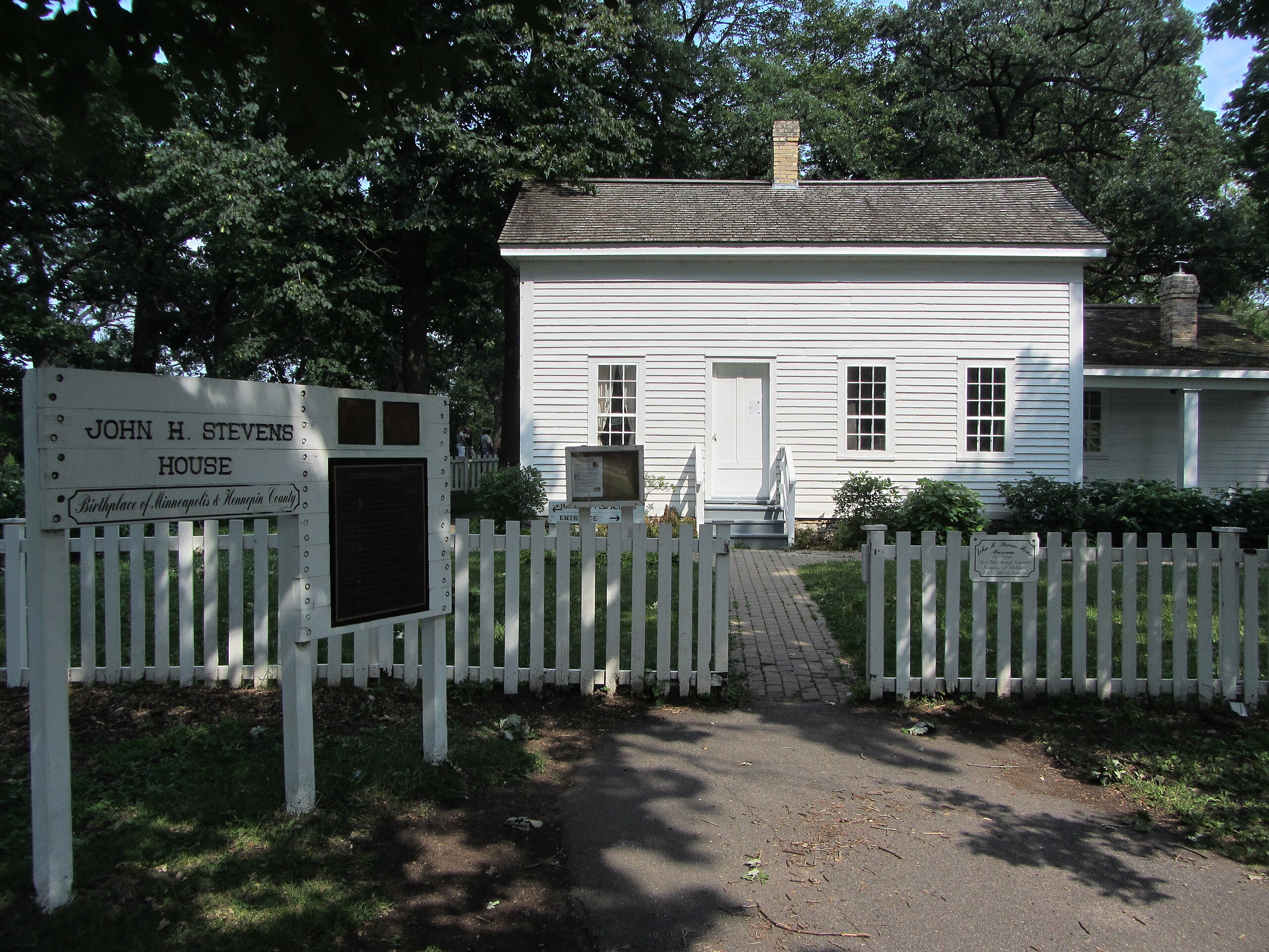
English: "JOHN HARRINGTON STEVENS HOUSE
"Built in 1850, this was the first house on the west bank of the Mississippi, located at Saint Anthony Falls near the present-day Minneapolis Post Office. "John H. Stevens received permission to occupy the site, a part of the Fort Snelling military reservation, in exchange for providing ferry service at Saint Anthony Falls. Steven's [sic] house and clain were known originally as the 'ferry farm.' "In the years 1850-1855, this house became the civic and social hub of the west bank settlement, earning the name "The Birthplace of Minneapolis". It was in this house that both the city of Minneapolis and Hennepin County were organized. "The JOHN H. STEVENS House is the earliest example of historic preservation in Minneapolis. In the 1890s, a Minneapolis Journal reporter located the house and started a campaign to preserve it. In 1896, the house was moved to Minnehaha Park, where it sat vacant until the 1980's. Restored to its original appearance by the Junior League of Minneapolis in cooperation with the Minneapolis Park and Recreation Board, the Stevens house was opened to the public in 1985 to commemorate the early history of Minneapolis 'This property has been placed on the National Register of Historic places by the United States Department of the Interior. 'Erected by the Junior League of Minneapolis 1985' |
Date | |
Source | https://www.flickr.com/photos/jason-riedy/7598430600/ |
Author | Jason Riedy |
Camera location | 44° 54′ 50.31″ N, 93° 12′ 35.85″ W | View this and other nearby images on: OpenStreetMap | 44.913976; -93.209958 |
---|
Licensing[edit]
- You are free:
- to share – to copy, distribute and transmit the work
- to remix – to adapt the work
- Under the following conditions:
- attribution – You must give appropriate credit, provide a link to the license, and indicate if changes were made. You may do so in any reasonable manner, but not in any way that suggests the licensor endorses you or your use.
This image was originally posted to Flickr by Jason Riedy at https://flickr.com/photos/66142667@N00/7598430600. It was reviewed on 14 January 2021 by FlickreviewR 2 and was confirmed to be licensed under the terms of the cc-by-2.0. |
14 January 2021
File history
Click on a date/time to view the file as it appeared at that time.
Date/Time | Thumbnail | Dimensions | User | Comment | |
---|---|---|---|---|---|
current | 01:25, 14 January 2021 | 4,000 × 3,000 (3.39 MB) | Myotus (talk | contribs) | Uploaded a work by Jason Riedy from https://www.flickr.com/photos/jason-riedy/7598430600/ with UploadWizard |
You cannot overwrite this file.
File usage on Commons
There are no pages that use this file.
File usage on other wikis
The following other wikis use this file:
- Usage on www.wikidata.org
Metadata
This file contains additional information such as Exif metadata which may have been added by the digital camera, scanner, or software program used to create or digitize it. If the file has been modified from its original state, some details such as the timestamp may not fully reflect those of the original file. The timestamp is only as accurate as the clock in the camera, and it may be completely wrong.
Camera manufacturer | Canon |
---|---|
Camera model | Canon PowerShot SX230 HS |
Exposure time | 1/800 sec (0.00125) |
F-number | f/4 |
ISO speed rating | 160 |
Date and time of data generation | 16:05, 14 July 2012 |
Lens focal length | 5 mm |
Latitude | 44° 54′ 50.32″ N |
Longitude | 93° 12′ 35.85″ W |
Altitude | 261.86 meters above sea level |
City shown | Minneapolis |
Headline | John H. Stevens house |
Copyright holder | Copyright 2012 Jason Riedy; licensed CC-BY http://creativecommons.org/licenses/by/3.0/ |
Image title | "JOHN HARRINGTON STEVENS HOUSE
"Built in 1850, this was the first house on the west bank of the Mississippi, located at Saint Anthony Falls near the present-day Minneapolis Post Office. "John H. Stevens received permission to occupy the site, a part of the Fort Snelling military reservation, in exchange for providing ferry service at Saint Anthony Falls. Steven's [sic] house and clain were known originally as the 'ferry farm.' "In the years 1850-1855, this house became the civic and social hub of the west bank settlement, earning the name "The Birthplace of Minneapolis". It was in this house that both the city of Minneapolis and Hennepin County were organized. "The JOHN H. STEVENS House is the earliest example of historic preservation in Minneapolis. In the 1890s, a Minneapolis Journal reporter located the house and started a campaign to preserve it. In 1896, the house was moved to Minnehaha Park, where it sat vacant until the 1980's. Restored to its original appearance by the Junior League of Minneapolis in cooperation with the Minneapolis Park and Recreation Board, the Stevens house was opened to the public in 1985 to commemorate the early history of Minneapolis 'This property has been placed on the National Register of Historic places by the United States Department of the Interior. 'Erected by the Junior League of Minneapolis 1985' |
Orientation | Normal |
Horizontal resolution | 180 dpi |
Vertical resolution | 180 dpi |
Software used | digiKam-2.6.0 |
File change date and time | 16:05, 14 July 2012 |
Y and C positioning | Co-sited |
Exif version | 2.3 |
Date and time of digitizing | 16:05, 14 July 2012 |
Meaning of each component |
|
Image compression mode | 3 |
APEX shutter speed | 9.65625 |
APEX aperture | 4 |
APEX exposure bias | 0 |
Maximum land aperture | 3.25 APEX (f/3.08) |
Metering mode | Pattern |
Flash | Flash did not fire, compulsory flash suppression |
Supported Flashpix version | 1 |
Color space | sRGB |
Focal plane X resolution | 16,393.442622951 |
Focal plane Y resolution | 16,393.442622951 |
Focal plane resolution unit | inches |
Sensing method | One-chip color area sensor |
File source | Digital still camera |
Custom image processing | Normal process |
Exposure mode | Auto exposure |
White balance | Auto white balance |
Digital zoom ratio | 1 |
Scene capture type | Standard |
GPS time (atomic clock) | 21:05 |
Receiver status | Measurement in progress |
Geodetic survey data used | WGS-84 |
GPS date | 14 July 2012 |
GPS tag version | 0.0.3.2 |
Rating (out of 5) | 0 |
IIM version | 2 |
Sublocation of city shown | Minnehaha Park |
Province or state shown | Minnesota |
Contact information | Jason Riedy <jason@lovesgoodfood.com> |