File:Josephinische Landaufnahme pg139.jpg
Jump to navigation
Jump to search

Size of this preview: 800 × 529 pixels. Other resolutions: 320 × 212 pixels | 640 × 423 pixels | 1,024 × 677 pixels | 1,280 × 846 pixels | 2,560 × 1,693 pixels | 8,379 × 5,540 pixels.
Original file (8,379 × 5,540 pixels, file size: 26.13 MB, MIME type: image/jpeg)
Captions
Captions
Add a one-line explanation of what this file represents
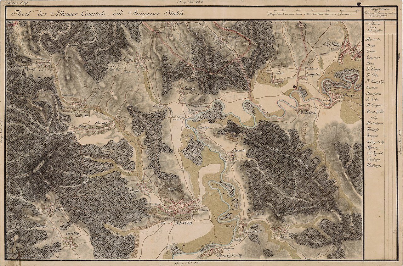
| Name shown on the map Nume din hartă |
Administrative unit Unitate administrativă |
Romanian name Numele românesc |
Hungarian name Numele unguresc |
German name Numele german |
Country today Ţara de astăzi |
|---|---|---|---|---|---|
| Nyirmezõ | Fehér megye Unterweißenburger Komitat Comitatul Alba de Jos |
Poiana Aiudului | Nyírmező, Oláhnyirmező | Birkenfeld, Birkau | Romania |
| Vládháza | Fehér megye | Livezile | Úrháza, Vládháza, Kákova | Lasslenkirch | Romania |
| Musina | Fehér megye | Măgina | Muzsnaháza, Muzsina | Mussendorf, Meschen | Romania |
| O. Lapad | Fehér megye | Lopadea Veche | Oláhlapád, Lapád | Romania | |
| Csako | Aranyos szék Scaunul Secuiesc al Arieşului |
Cicău | Csákó | Romania | |
| Mirászlo | Fehér megye | Mirăslău | Miriszló, Oláhmiriszló | Romania | |
| Örményes | Aranyos szék | Ormeniş | Marosörményes | Romania | |
| Detse | Torda megye Komitat Torda Comitatul Turda |
Decea | Marosdécse | Romania | |
| Gombos | Fehér megye | Gâmbaş | Marosgombás | Schwammenthal | Romania |
| Fel Vitz | Aranyos szék | Unirea | Felvinc, Aranyosvinc, Vinc | Oberwinz, Ober-Weinsdorf, Winzendorf | Romania |
| Inohfalva | Aranyos szék | Inoc | Inakfalva, Inakháza, Inoktelke | Romania | |
| Nagy Csesztve | Fehér megye | Cisteiu de Mureş | Magyarcsesztve | Thalmühl | Romania |
| Mikloslaka | Fehér megye | Micoşlaca | Miklóslaka | Nickelsdorf | Romania |
| Apahida | Fehér megye | Păgida | Kisapahida, Oláhapahida, Apahida | Bruckendorf | Romania |
| Bago | Fehér megye | Băgău | Magyarbagó, Oláhbagó, Bagó | Bogun | Romania |
| Csombord | Fehér megye | Ciumbrud | Csombord | Poley | Romania |
| Maros Sz. Kyrály | Fehér megye | Sâncrai | Enyedszentkirály, Marosszentkirály, Szentkirály | Königsdorf | Romania |
| N: Enyed | Fehér megye | Aiud | Enyed, Nagyenyed | Straßburg am Mieresch, Strassburg am Mieresch, Grossenyed, Engeten, Egydstadt | Romania |
| F: Enjed | Fehér megye | Aiudul de Sus | Felenyed | Egisdorf, Egydsdorf | Romania |
| Kis Orbo | Fehér megye | Gârboviţa | Középorbó | Kleinurbau | Romania |
| F: Orbo | Fehér megye | Gârbova de Sus | Felsõorbó | Orbau, Oberurbau | Romania |
Summary[edit]
| Description |
English: Grand Duchy of Transylvania, 1769-1773. Josephinische Landaufnahme pg.139 Română: Harta Iosefină a Transilvaniei, 1769-1773. Josephinische Landaufnahme pg.139 |
||||
| Date | between 1769 and 1773 | ||||
| Source | Österreichisches Staatsarchiv, Kriegsarchiv, B IX 715: Original-Aufnahmskarte des Grossfürtenthums Siebenbürgen. Geometrisch aufgenommen und bearbeitet in den Jahren 1769 bis 1773 unter der Direction des Obristen von Fabris, theils durch Officiere des grossen Feld-Generalstabes, theils auch von verschiedenen aus dem in Siebenbürgen bequartierten Regimentern zu diesem Geschäfte beigezogenen Individuen | ||||
| Author | Historische Militärkarte der österreichisch-ungarischen Monarchie | ||||
| Permission (Reusing this file) |
|
||||
Clickable Map of the Grand Duchy of Transylvania[edit]
File history
Click on a date/time to view the file as it appeared at that time.
| Date/Time | Thumbnail | Dimensions | User | Comment | |
|---|---|---|---|---|---|
| current | 17:33, 7 December 2009 | | 8,379 × 5,540 (26.13 MB) | Asybaris01 (talk | contribs) | good rezolution |
| 07:48, 28 October 2009 |  | 5,446 × 3,601 (17.4 MB) | Asybaris01 (talk | contribs) | {{Information |Description={{ro|1=Josephinische Landaufnahme pg139}} |Source=Josephinische Landaufnahme pg139 |Author=Asybaris01 |Date=2009/10/28 |Permission= |other_versions= }} |
You cannot overwrite this file.
File usage on Commons
The following 4 pages use this file:
File usage on other wikis
The following other wikis use this file:
- Usage on arz.wikipedia.org
- Usage on eo.wikipedia.org
- Usage on es.wikipedia.org
- Usage on hu.wikipedia.org
- Usage on ro.wikipedia.org
- Aiud
- Aiudul de Sus, Alba
- Băgău, Alba
- Cicău, Alba
- Cisteiu de Mureș, Alba
- Ciumbrud, Alba
- Decea, Alba
- Gâmbaș, Alba
- Gârbova de Sus, Alba
- Gârbovița, Alba
- Inoc, Alba
- Livezile, Alba
- Lopadea Veche, Alba
- Măgina, Alba
- Micoșlaca, Alba
- Mirăslău, Alba
- Ormeniș, Alba
- Păgida, Alba
- Poiana Aiudului, Alba
- Sâncrai, Alba
- Unirea, Alba
- Comuna Unirea, Alba
- Usage on tt.wikipedia.org
- Usage on www.wikidata.org
View more global usage of this file.