File:Junction of paths to Corfe Castle - geograph.org.uk - 1026322.jpg
Jump to navigation
Jump to search
No higher resolution available.
Junction_of_paths_to_Corfe_Castle_-_geograph.org.uk_-_1026322.jpg (640 × 427 pixels, file size: 89 KB, MIME type: image/jpeg)
Captions
Captions
Add a one-line explanation of what this file represents
Summary[edit]
| Description |
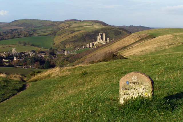
English: Junction of paths to Corfe Castle At this point the bridleway descends gently down the southern side of Challow Hill towards Corfe Castle. A permissive path continues along the top of the ridge to East Hill, then descends rapidly via a set of steps. Corfe Castle can be seen in the middle distance, perched on Castle Hill in the Corfe Gap in the Purbeck chalk ridge. The village of Corfe Castle is to the left, with the church tower standing out prominently. |
| Date | |
| Source | From geograph.org.uk |
| Author | Jim Champion |
| Attribution (required by the license) | Jim Champion / Junction of paths to Corfe Castle / |
| Camera location | | View this and other nearby images on: OpenStreetMap |
|---|
_heading:270.00&language=en)
| Object location | | View this and other nearby images on: OpenStreetMap |
|---|
_heading:270.00&language=en)
Licensing[edit]

|
This image was taken from the Geograph project collection. See this photograph's page on the Geograph website for the photographer's contact details. The copyright on this image is owned by Jim Champion and is licensed for reuse under the Creative Commons Attribution-ShareAlike 2.0 license.
|
This file is licensed under the Creative Commons Attribution-Share Alike 2.0 Generic license.
Attribution: Jim Champion
- You are free:
- to share – to copy, distribute and transmit the work
- to remix – to adapt the work
- Under the following conditions:
- attribution – You must give appropriate credit, provide a link to the license, and indicate if changes were made. You may do so in any reasonable manner, but not in any way that suggests the licensor endorses you or your use.
- share alike – If you remix, transform, or build upon the material, you must distribute your contributions under the same or compatible license as the original.
File history
Click on a date/time to view the file as it appeared at that time.
| Date/Time | Thumbnail | Dimensions | User | Comment | |
|---|---|---|---|---|---|
| current | 14:32, 23 February 2011 | | 640 × 427 (89 KB) | GeographBot (talk | contribs) | == {{int:filedesc}} == {{Information |description={{en|1=Junction of paths to Corfe Castle At this point the bridleway descends gently down the southern side of Challow Hill towards Corfe Castle. A permissive path continues along the top of the ridge to E |
You cannot overwrite this file.
File usage on Commons
There are no pages that use this file.