File:Karte Caudry.png
Jump to navigation
Jump to search

Size of this preview: 612 × 600 pixels. Other resolutions: 245 × 240 pixels | 490 × 480 pixels | 994 × 974 pixels.
Original file (994 × 974 pixels, file size: 142 KB, MIME type: image/png)
Captions
Captions
Add a one-line explanation of what this file represents
Summary
[edit]
| Description |
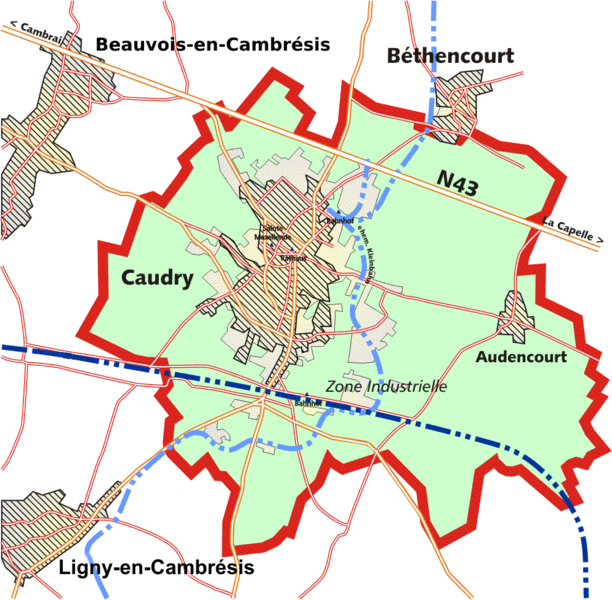
English: map of caudry, France Nord department in 1914 and in 2000 incl. most important roads an all railway tracks and narrow gauge railways (light blue)
Français : carte de Caudry (Nord, France) et environs en 1914 et 2000, avec les routes principales, les voies de ch. de fer y/c le ch. de fer à voie étroite (bleu clair) |
| Date | |
| Source | Own work |
| Author | Lantus |
Licensing
[edit]
I, the copyright holder of this work, hereby publish it under the following licenses:

|
Permission is granted to copy, distribute and/or modify this document under the terms of the GNU Free Documentation License, Version 1.2 or any later version published by the Free Software Foundation; with no Invariant Sections, no Front-Cover Texts, and no Back-Cover Texts. A copy of the license is included in the section entitled GNU Free Documentation License. |
| This file is licensed under the Creative Commons Attribution-Share Alike 3.0 Unported license. | ||
| ||
| This licensing tag was added to this file as part of the GFDL licensing update. |
This file is licensed under the Creative Commons Attribution-Share Alike 2.5 Generic, 2.0 Generic and 1.0 Generic license.
- You are free:
- to share – to copy, distribute and transmit the work
- to remix – to adapt the work
- Under the following conditions:
- attribution – You must give appropriate credit, provide a link to the license, and indicate if changes were made. You may do so in any reasonable manner, but not in any way that suggests the licensor endorses you or your use.
- share alike – If you remix, transform, or build upon the material, you must distribute your contributions under the same or compatible license as the original.
You may select the license of your choice.

|
This photo, this drawing or graph was taken by Lantus. If you use one of my photos, drawings or graphs, an email (account needed) or a message would be greatly appreciated. |
File history
Click on a date/time to view the file as it appeared at that time.
| Date/Time | Thumbnail | Dimensions | User | Comment | |
|---|---|---|---|---|---|
| current | 23:26, 4 June 2015 | | 994 × 974 (142 KB) | Cmdrjameson (talk | contribs) | Compressed with pngout. Reduced by 98kB (40% decrease). |
| 17:13, 10 May 2011 |  | 994 × 974 (240 KB) | Cj73 (talk | contribs) | Modification de ''Beauvais'' en ''Beauvois-en-Cambrésis'' et de ''Ligny-Haucourt'' en ''Ligny-en-Cambrésis'' (changement de nom en 1997). | |
| 22:23, 27 May 2007 |  | 994 × 974 (130 KB) | Lantus (talk | contribs) | {{Information |Description= map of caudry, France nord department in 1914 and in 2000 incl. most important roads an all railway tracks and Narrow gauge railways (light blue) |Source=self-made |Date= 17.02.2007 |Author= User:Lantus }} |
You cannot overwrite this file.
File usage on Commons
The following page uses this file:
File usage on other wikis
The following other wikis use this file:
- Usage on ar.wikipedia.org
- Usage on de.wikipedia.org
- Usage on fr.wikipedia.org