File:Karte Confederation Bridge.png
Jump to navigation
Jump to search
Size of this preview: 622 × 600 pixels. Other resolutions: 249 × 240 pixels | 498 × 480 pixels | 797 × 768 pixels | 1,062 × 1,024 pixels | 1,536 × 1,481 pixels.
Original file (1,536 × 1,481 pixels, file size: 591 KB, MIME type: image/png)
Captions
Captions
Add a one-line explanation of what this file represents
Summary[edit]
| Description |
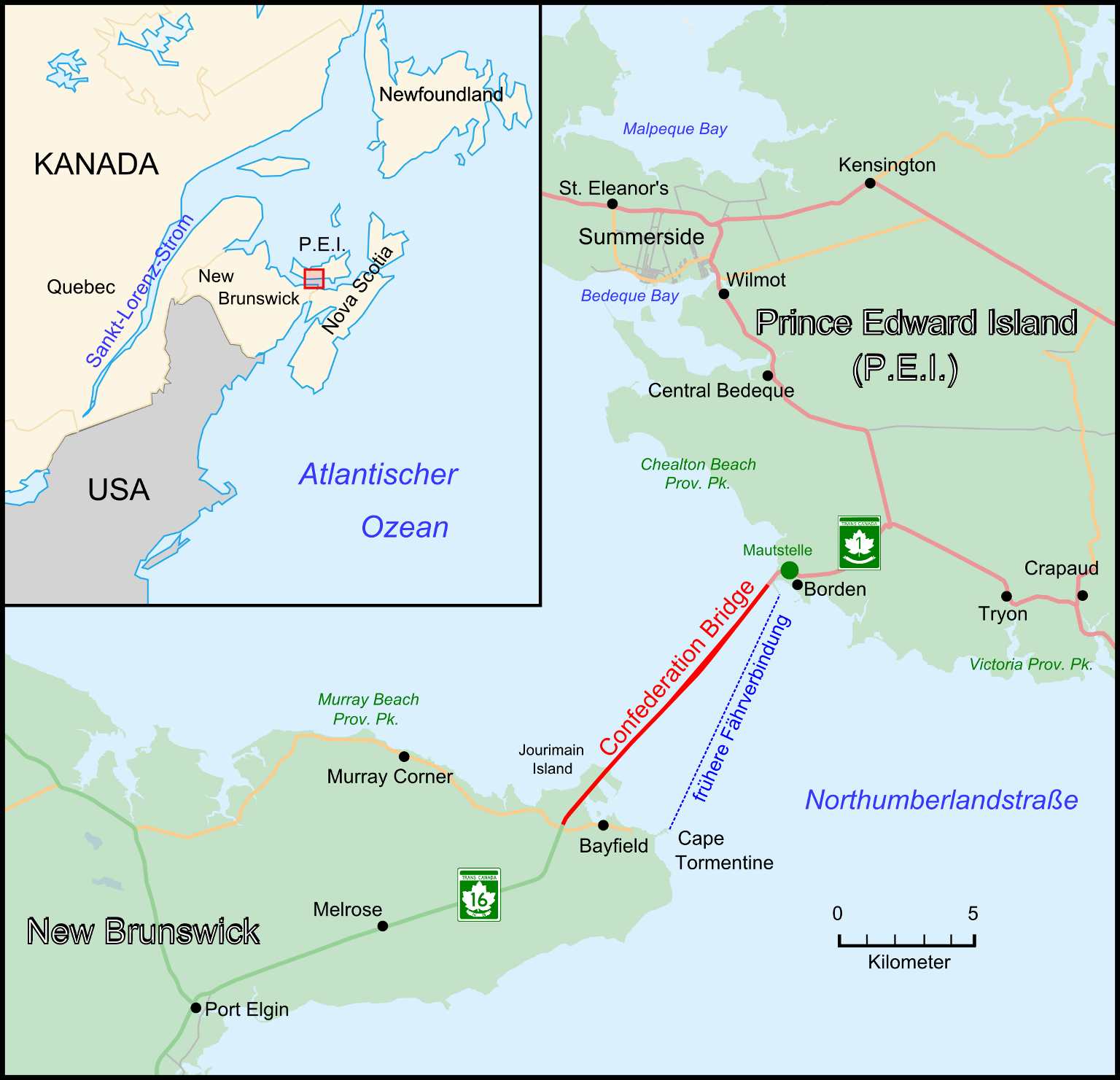
Deutsch: Lagekarte zur Confederation Bridge English: Map showing position of Confederation Bridge in easten Canada |
| Date | |
| Source | Own work |
| Author | Wladyslaw |
Licensing[edit]
Wladyslaw, the copyright holder of this work, hereby publishes it under the following licenses:
| Copyleft: This work of art is free; you can redistribute it and/or modify it according to terms of the Free Art License. You will find a specimen of this license on the Copyleft Attitude site as well as on other sites. |

|
Permission is granted to copy, distribute and/or modify this document under the terms of the GNU Free Documentation License, Version 1.2 or any later version published by the Free Software Foundation; with no Invariant Sections, no Front-Cover Texts, and no Back-Cover Texts. A copy of the license is included in the section entitled GNU Free Documentation License. |
This file is licensed under the Creative Commons Attribution-Share Alike 3.0 Germany license.
Attribution: Wladyslaw
- You are free:
- to share – to copy, distribute and transmit the work
- to remix – to adapt the work
- Under the following conditions:
- attribution – You must give appropriate credit, provide a link to the license, and indicate if changes were made. You may do so in any reasonable manner, but not in any way that suggests the licensor endorses you or your use.
- share alike – If you remix, transform, or build upon the material, you must distribute your contributions under the same or compatible license as the original.

You may select the license of your choice.
Original upload log[edit]
The original description page was here. All following user names refer to de.wikipedia.
- 2009-11-17 21:26 Taxiarchos228 1536×1481× (605284 bytes) {{Information |Beschreibung = |Quelle = |Urheber = |Datum = |Genehmigung = |Andere Versionen = |Anmerkungen = }}
- 2009-11-05 21:59 Taxiarchos228 1605×1548× (641621 bytes) {{Information |Beschreibung = |Quelle = |Urheber = |Datum = |Genehmigung = |Andere Versionen = |Anmerkungen = }}
- 2009-11-05 21:56 Taxiarchos228 1605×1548× (642245 bytes) {{Information |Beschreibung = |Quelle = |Urheber = |Datum = |Genehmigung = |Andere Versionen = |Anmerkungen = }}
- 2009-10-31 22:49 Taxiarchos228 1605×1548× (533464 bytes) {{Information |Beschreibung = |Quelle = |Urheber = |Datum = |Genehmigung = |Andere Versionen = |Anmerkungen = }}
- 2009-10-31 21:19 Taxiarchos228 1605×1548× (514167 bytes) {{Information |Beschreibung = |Quelle = |Urheber = |Datum = |Genehmigung = |Andere Versionen = |Anmerkungen = }}
- 2009-10-30 21:54 Taxiarchos228 1605×1548× (504252 bytes) {{Information |Beschreibung = |Quelle = |Urheber = |Datum = |Genehmigung = |Andere Versionen = |Anmerkungen = }}
- 2009-10-30 21:53 Taxiarchos228 2293×2211× (558724 bytes) {{Information |Beschreibung = |Quelle = |Urheber = |Datum = |Genehmigung = |Andere Versionen = |Anmerkungen = }}
- 2009-10-30 21:48 Taxiarchos228 1605×1548× (504280 bytes) {{Information |Beschreibung = |Quelle = |Urheber = |Datum = |Genehmigung = |Andere Versionen = |Anmerkungen = }}
- 2009-10-30 21:37 Taxiarchos228 1605×1548× (490954 bytes) {{Information |Beschreibung = |Quelle = |Urheber = |Datum = |Genehmigung = |Andere Versionen = |Anmerkungen = }}
- 2009-10-30 21:35 Taxiarchos228 1605×1548× (491226 bytes) {{Information |Beschreibung = |Quelle = |Urheber = |Datum = |Genehmigung = |Andere Versionen = |Anmerkungen = }}
- 2009-10-29 21:13 Taxiarchos228 3960×2632× (1141156 bytes) {{Information |Beschreibung = Lagekarte zur Confederation Bridge |Quelle = selbst erstellt auf Basis von http://www.openstreetmap.org/ |Urheber = ~~~ |Datum = 29. Oktober 2009 |Genehmigung = |Andere Versionen = |Anmerkungen = }}
File history
Click on a date/time to view the file as it appeared at that time.
| Date/Time | Thumbnail | Dimensions | User | Comment | |
|---|---|---|---|---|---|
| current | 15:54, 19 October 2010 | | 1,536 × 1,481 (591 KB) | File Upload Bot (Magnus Manske) (talk | contribs) | {{BotMoveToCommons|de.wikipedia|year={{subst:CURRENTYEAR}}|month={{subst:CURRENTMONTHNAME}}|day={{subst:CURRENTDAY}}}} {{Information |Description={{de|Lagekarte zur Confederation Bridge}} |Source=Transferred from [http://de.wikipedia.org de.wikipedia]; t |
You cannot overwrite this file.
File usage on Commons
The following 2 pages use this file:
File usage on other wikis
The following other wikis use this file:
- Usage on ar.wikipedia.org
- Usage on arz.wikipedia.org
- Usage on de.wikipedia.org
- Usage on uk.wikipedia.org
- Usage on www.wikidata.org