File:Karte der Amerikalinie (Bahnstrecke).png
Jump to navigation
Jump to search
Size of this preview: 800 × 234 pixels. Other resolutions: 320 × 94 pixels | 640 × 187 pixels | 1,024 × 299 pixels | 1,280 × 374 pixels | 4,790 × 1,400 pixels.
Original file (4,790 × 1,400 pixels, file size: 1.77 MB, MIME type: image/png)
Captions
Captions
Add a one-line explanation of what this file represents
| Description |
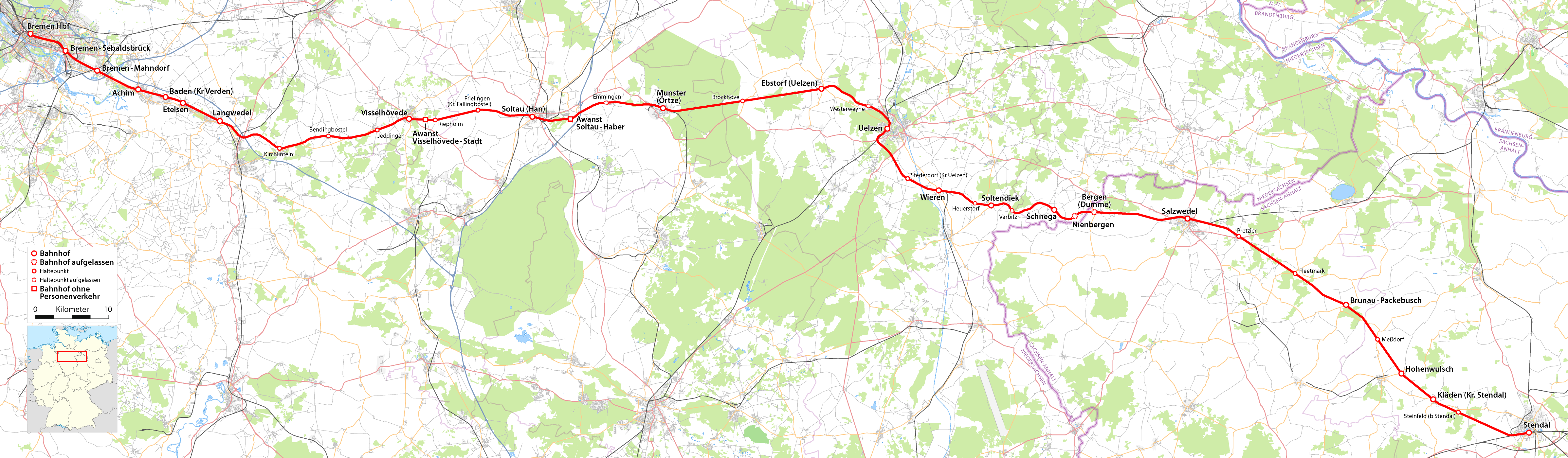
Deutsch: Karte der Amerikalinie (Bahnstrecke) |
| Date | see file history |
| Source |
{own}, using
|
| Author | Maximilian Dörrbecker (Chumwa) |
| Permission (Reusing this file) |
All OpenStreetMap data and maps are Creative Commons "CC-BY-SA 2.0" licensed This file is licensed under the Creative Commons Attribution-Share Alike 2.0 Generic license.
|
| Other versions |
|


File history
Click on a date/time to view the file as it appeared at that time.
| Date/Time | Thumbnail | Dimensions | User | Comment | |
|---|---|---|---|---|---|
| current | 08:45, 5 February 2012 | 4,790 × 1,400 (1.77 MB) | Chumwa (talk | contribs) | coor | |
| 20:19, 8 February 2011 | 4,790 × 1,400 (1.68 MB) | Chumwa (talk | contribs) | Ebsdorf -> Ebstorf | ||
| 14:18, 8 August 2009 | 4,790 × 1,400 (1.68 MB) | Chumwa (talk | contribs) | Ländergrenzen hinzugefügt | ||
| 14:51, 2 August 2009 | 4,790 × 1,400 (1.64 MB) | Chumwa (talk | contribs) | {{Information |Description={{de|Karte der Amerikalinie (Bahnstrecke)}} |Author=Maximilian Dörrbecker (Chumwa) |Source={own}, using * OpenStreetMap data for the background * [[:File:Germany_location_map.svg|this |
You cannot overwrite this file.
File usage on Commons
The following 10 pages use this file:
- User:Chumwa/Gallery
- File:Bahnstrecken in Niedersachsen - Gesamtbearbeitung.png
- File:Karte der Amerikalinie (Bahnstrecke).png
- File:Karte der Bahnstrecke Buchholz - Hannover.png
- File:Karte der Bahnstrecke Buchholz - Wittenberge.png
- File:Karte der Bahnstrecke Dannenberg - Salzwedel.png
- File:Karte der Bahnstrecke Langwedel - Uelzen.png
- File:Karte der Bahnstrecke Uelzen - Braunschweig.png
- File:Karte der Bahnstrecke Uelzen - Dannenberg.png
- File:Karte der Bahnstrecke Uelzen - Stendal.png
.png)
File usage on other wikis
The following other wikis use this file:
- Usage on de.wikipedia.org
- Usage on en.wikipedia.org
- Usage on nds.wikipedia.org
- Usage on nl.wikipedia.org
- Usage on www.wikidata.org
.png&oldid=475900952)