File:Kashmir region. LOC 2003626427 - showing sub-regions administered by different countries.jpg
Jump to navigation
Jump to search

Size of this preview: 560 × 599 pixels. Other resolutions: 224 × 240 pixels | 448 × 480 pixels | 718 × 768 pixels | 957 × 1,024 pixels | 1,914 × 2,048 pixels | 4,597 × 4,920 pixels.
Original file (4,597 × 4,920 pixels, file size: 6 MB, MIME type: image/jpeg)
Captions
Captions
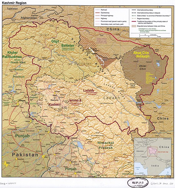
The disputed Kashmir region, showing the sub-regions administered by India, Pakistan, and China
Summary[edit]
| Description |
English: The disputed Kashmir region, showing the sub-regions administered by India, Pakistan, and China |
| Date | |
| Source | https://upload.wikimedia.org/wikipedia/commons/8/8f/Kashmir_region._LOC_2003626427.jpg |
| Author | US Central Intelligence Agency (old labels removed, new added by Fowler&fowler (talk) 02:56, 11 April 2022 (UTC)) |
| Other versions |
 |
Licensing[edit]
This work is in the public domain in the United States because it is a work prepared by an officer or employee of the United States Government as part of that person’s official duties under the terms of Title 17, Chapter 1, Section 105 of the US Code.
Note: This only applies to original works of the Federal Government and not to the work of any individual U.S. state, territory, commonwealth, county, municipality, or any other subdivision. This template also does not apply to postage stamp designs published by the United States Postal Service since 1978. (See § 313.6(C)(1) of Compendium of U.S. Copyright Office Practices). It also does not apply to certain US coins; see The US Mint Terms of Use.
|
 | |
| This file has been identified as being free of known restrictions under copyright law, including all related and neighboring rights. | ||
File history
Click on a date/time to view the file as it appeared at that time.
| Date/Time | Thumbnail | Dimensions | User | Comment | |
|---|---|---|---|---|---|
| current | 02:31, 4 July 2023 | | 4,597 × 4,920 (6 MB) | Fowler&fowler (talk | contribs) | Reverted to version as of 14:18, 12 April 2022 (UTC) |
| 14:46, 24 June 2023 |  | 4,597 × 4,920 (3.74 MB) | Geographyinitiative (talk | contribs) | There is no evidence that Demchok sector is part of Aksai Chin. The original map is good enough and the yellow scribbles attempt to steal the authority of the professional cartographers. | |
| 14:18, 12 April 2022 |  | 4,597 × 4,920 (6 MB) | Fowler&fowler (talk | contribs) | Added Peaks | |
| 02:56, 11 April 2022 |  | 4,597 × 4,920 (6 MB) | Fowler&fowler (talk | contribs) | Uploaded a work by US Central Intelligence Agency (old labels removed, new added by ~~~~) from https://upload.wikimedia.org/wikipedia/commons/8/8f/Kashmir_region._LOC_2003626427.jpg with UploadWizard |
You cannot overwrite this file.
File usage on Commons
The following page uses this file:
File usage on other wikis
The following other wikis use this file:
- Usage on en.wikipedia.org
- Azad Kashmir
- Kashmir
- Aksai Chin
- Ladakh
- Gilgit
- Skardu
- Muzaffarabad
- Bagh District
- Bhimber District
- Kotli District
- Muzaffarabad District
- Poonch District, Pakistan
- Mirpur District
- Insurgency in Jammu and Kashmir
- Kashmir conflict
- Kargil
- Proposed states and union territories of India
- Chilas
- Ghanche District
- Skardu District
- Gilgit District
- Astore District
- Sudhanoti District
- Neelum District
- Jammu and Kashmir (princely state)
- Portal:Pakistan/Selected article/Previous selected articles
- Gilgit-Baltistan
- Portal:Pakistan/Selected article
- Haveli District
- Hattian Bala District
- Nagar District
- Roundu District
- Exodus of Kashmiri Hindus
- Shigar District
- Kharmang District
- Hunza District
- Gilgit Division
- Baltistan Division
- Diamer Division
- Gupis-Yasin District
- Jammu and Kashmir (union territory)
- Revocation of the special status of Jammu and Kashmir
- Portal:Pakistan/Selected article/31
- User:Falcaorib
- Darel District
- Ghizer District (2019–)
- User:Christophervincent01
- Talk:Himalayas/Archive 5
- Talk:Srinagar/Archive 1
- Usage on fa.wikipedia.org
View more global usage of this file.