File:Kelenföld-Háros szembeközlekedés térkép.jpg
Jump to navigation
Jump to search

Size of this preview: 770 × 600 pixels. Other resolutions: 308 × 240 pixels | 617 × 480 pixels | 786 × 612 pixels.
Original file (786 × 612 pixels, file size: 397 KB, MIME type: image/jpeg)
Captions
Captions
Add a one-line explanation of what this file represents
Summary[edit]
| Description |
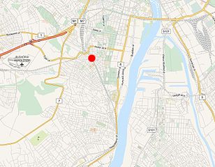
Magyar: Kelenföld–Háros közötti vasúti pálya és a 2013. szeptember 14-én bekövetkezett Kelenföld-hárosi vasúti veszélyhelyzet hozzávetőleges helyszíne |
| Date | |
| Source | OpenStreetMap |
| Author | OpenStreetMap |
Licensing[edit]
| Description |
Kelenföld-hárosi vasúti veszélyhelyzet This map was created from OpenStreetMap project data, collected by the community. This map may be incomplete, and may contain errors. Don't rely solely on it for navigation. |
|||
| Date | ||||
| Source | openstreetmap.org | |||
| Creator |
OpenStreetMap contributors |
|||
| Permission (Reusing this file) |
OpenStreetMap data is available under the Open Database License (details). Map tiles are licensed under the Creative Commons Attribution-ShareAlike 2.0 license (CC-BY-SA 2.0).
This file is licensed under the Creative Commons Attribution-Share Alike 2.0 Generic license.
|
|||
| Georeferencing | If inappropriate please set warp_status = skip to hide. |
Original upload log[edit]
The original description page was here. All following user names refer to hu.wikipedia.
| Date/Time | Dimensions | User | Comment |
|---|---|---|---|
| 2013-09-14 20:51 | 786×612× (406332 bytes) | Áthaladójelző | {{Információ | leírás = Kelenföld–Háros közötti vasúti pálya és az esemény hozzávetőleges helyszíne | forrás = http://www.openstreetmap.org | dátum = 2013.09.14. | helyszín = Budapest }} |
File history
Click on a date/time to view the file as it appeared at that time.
| Date/Time | Thumbnail | Dimensions | User | Comment | |
|---|---|---|---|---|---|
| current | 18:37, 24 May 2016 | | 786 × 612 (397 KB) | Regasterios (talk | contribs) | Transferred from hu.wikipedia |
You cannot overwrite this file.
File usage on Commons
The following page uses this file:
File usage on other wikis
The following other wikis use this file:
- Usage on hu.wikipedia.org