File:Kingdom of Hungary - Ethnic Map - 1495.jpg
Jump to navigation
Jump to search
Size of this preview: 800 × 560 pixels. Other resolutions: 320 × 224 pixels | 640 × 448 pixels | 1,024 × 716 pixels | 1,280 × 895 pixels | 2,560 × 1,791 pixels | 4,771 × 3,337 pixels.
Original file (4,771 × 3,337 pixels, file size: 11.96 MB, MIME type: image/jpeg)
Captions
Captions
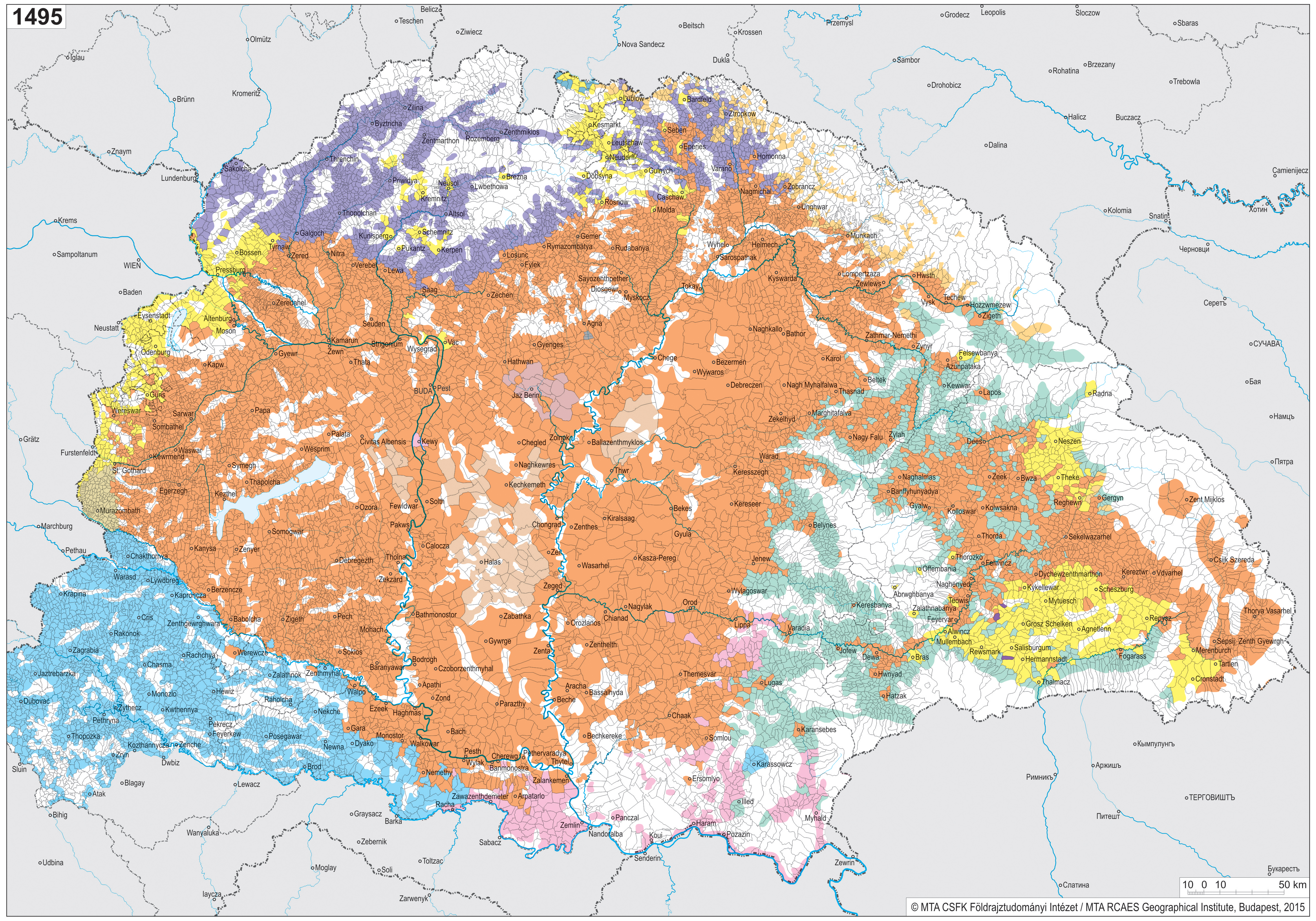
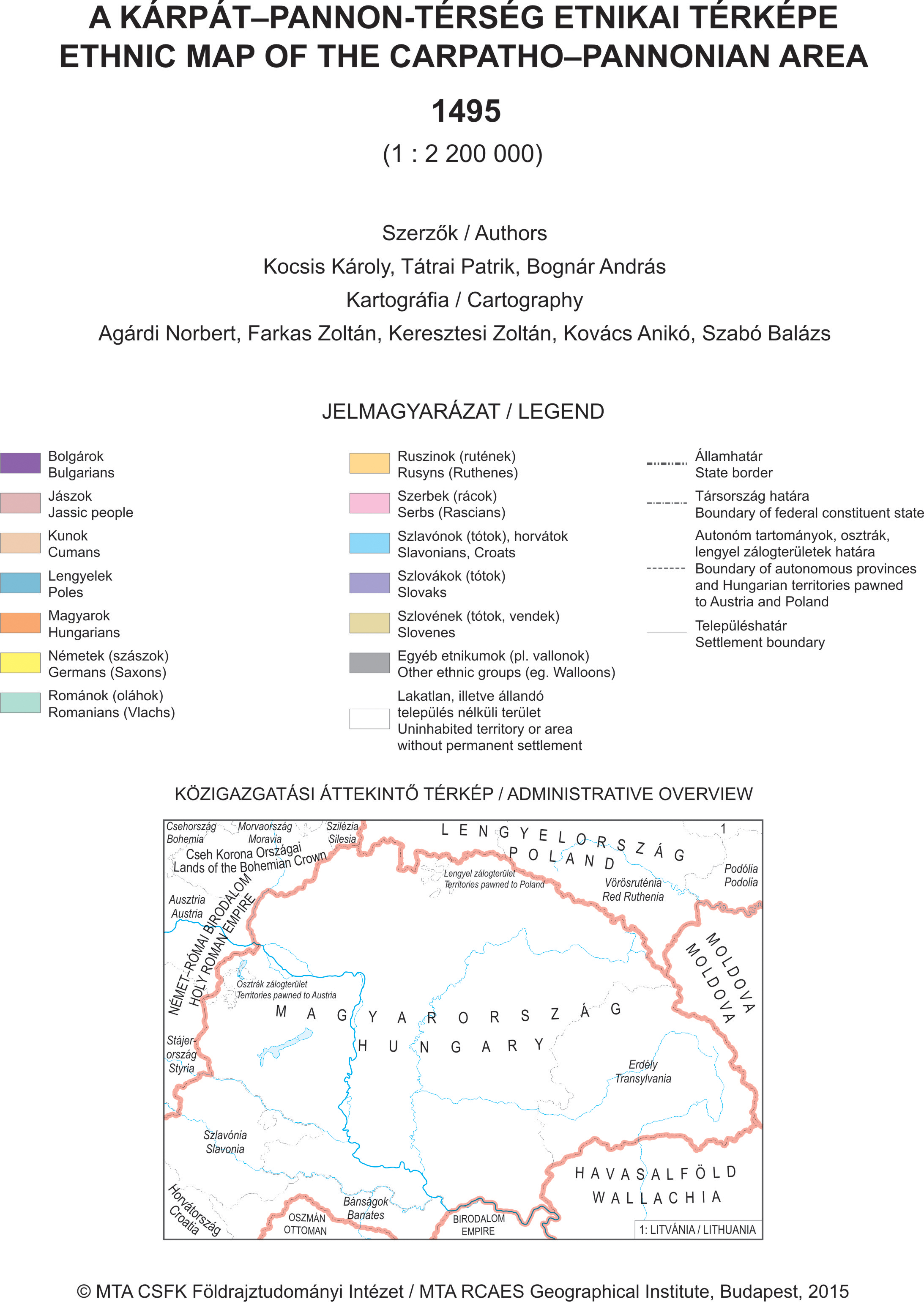
Ethnic map of the Carpatho−Pannonian area 1495
Summary
[edit]
| Description |
Magyar: A Kárpát−Pannon-térség etnikai térképe 1495 Jelmagyarázat: http://www.mtafki.hu/konyvtar/karpat-pannon2015/images/1495_1A.jpg English: Ethnic map of the Carpatho−Pannonian area 1495 Legend: http://www.mtafki.hu/konyvtar/karpat-pannon2015/images/1495_1A.jpg |
| Date | |
| Source |
Magyar: Kiadó: Magyar Tudományos Akadémia Csillagászati és Földtudományi Kutatóközpont Földrajztudományi Intézet, http://www.mtafki.hu/konyvtar/karpat-pannon2015/mellekterkepek.html English: Publisher: The Hungarian Academy of Sciences - Research Centre for Astronomy and Earth Sciences Geographical Institute, http://www.mtafki.hu/konyvtar/karpat-pannon2015/en/supplementary_maps.html |
| Author |
Magyar: Szerzők: A Kocsis Károly, Tátrai Patrik, Agárdi Norbert, Balizs Dániel, Bognár András, Bottlik Zsolt, Kovács Anikó, Varga E. Árpád Kartográfia: Agárdi Norbert, Farkas Zoltán, Keresztesi Zoltán, Koczó Fanni, Kovács Anikó, Nemerkényi Zsombor, Szabó Balázs, Szabó Renáta Domborzatárnyékolás: Sziládi József Egyéb térképészeti munkálatok: Bagaméri Gergely, Balázs Éva, Butor Zsanett, Gertheis Anna, Szigeti Csaba, Veszely Zsuzsanna Lektorálta: Gercsák Gábor, Klinghammer István English: Authors: Károly Kocsis, Patrik Tátrai, Norbert Agárdi, Dániel Balizs, András Bognár, Zsolt Bottlik, Anikó Kovács, Árpád E. Varga Cartography: Norbert Agárdi, Zoltán Farkas, Zoltán Keresztesi, Fanni Koczó, Anikó Kovács, Zsombor Nemerkényi, Balázs Szabó, Renáta Szabó Hill-shading: József Sziládi Additional cartographic works: Gergely Bagaméri, Éva Balázs, Zsanett Butor, Anna Gertheis, Csaba Szigeti, Zsuzsanna Veszely Revised by: Gábor Gercsák, István Klinghammer |
| Permission (Reusing this file) |
Licensing
[edit]
This file is licensed under the Creative Commons Attribution-Share Alike 4.0 International license.
- You are free:
- to share – to copy, distribute and transmit the work
- to remix – to adapt the work
- Under the following conditions:
- attribution – You must give appropriate credit, provide a link to the license, and indicate if changes were made. You may do so in any reasonable manner, but not in any way that suggests the licensor endorses you or your use.
- share alike – If you remix, transform, or build upon the material, you must distribute your contributions under the same or compatible license as the original.
File history
Click on a date/time to view the file as it appeared at that time.
| Date/Time | Thumbnail | Dimensions | User | Comment | |
|---|---|---|---|---|---|
| current | 16:27, 2 February 2023 | | 4,771 × 3,337 (11.96 MB) | OrionNimrod (talk | contribs) | Uploaded a work by MTA research Centre for Astronomy and Earth Sciences Geographical Institute from http://www.mtafki.hu/konyvtar/karpat-pannon2015/en/supplementary_maps.html with UploadWizard |
You cannot overwrite this file.
File usage on Commons
There are no pages that use this file.
File usage on other wikis
The following other wikis use this file:
- Usage on de.wikipedia.org
- Usage on en.wikipedia.org