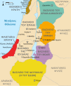
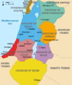
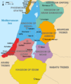
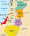
File:Kingdoms of Israel and Judah map 830-ar.svg
From Wikimedia Commons, the free media repository
Jump to navigation
Jump to search

Size of this PNG preview of this SVG file: 502 × 599 pixels. Other resolutions: 201 × 240 pixels | 402 × 480 pixels | 644 × 768 pixels | 858 × 1,024 pixels | 1,717 × 2,048 pixels | 720 × 859 pixels.
Original file (SVG file, nominally 720 × 859 pixels, file size: 310 KB)
File information
Structured data
Captions
Captions
Add a one-line explanation of what this file represents
Summary[edit]
| DescriptionKingdoms of Israel and Judah map 830-ar.svg |
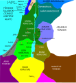
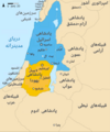
العربية: خريطة تقريبية تظهر مملكة إسرائيل (بالأزرق) مملكة يهوذا (البرتقالي) في حوالي القرن التاسع قبل الميلاد.
English: Approximate map showing the Kingdoms of Israel (blue) and Judah (orange) in the 9th century BCE. |
|||||||||||||||||
| Date | ||||||||||||||||||
| Source | Derivative from this file | |||||||||||||||||
| Author |
creator QS:P170,Q81411358 |
|||||||||||||||||
| Other versions |
[edit]
|
|||||||||||||||||
| This is a retouched picture, which means that it has been digitally altered from its original version. Modifications: Translated to Arabic - عُرّبت. The original can be viewed here: Kingdoms of Israel and Judah map 830: File:Kingdoms of Israel and Judah map 830. Modifications made by Michel Bakni.
|
Licensing[edit]
I, the copyright holder of this work, hereby publish it under the following license:
This file is licensed under the Creative Commons Attribution-Share Alike 4.0 International license.
- You are free:
- to share – to copy, distribute and transmit the work
- to remix – to adapt the work
- Under the following conditions:
- attribution – You must give appropriate credit, provide a link to the license, and indicate if changes were made. You may do so in any reasonable manner, but not in any way that suggests the licensor endorses you or your use.
- share alike – If you remix, transform, or build upon the material, you must distribute your contributions under the same or compatible license as the original.
File history
Click on a date/time to view the file as it appeared at that time.
| Date/Time | Thumbnail | Dimensions | User | Comment | |
|---|---|---|---|---|---|
| current | 17:22, 3 January 2019 |  | 720 × 859 (310 KB) | Michel Bakni (talk | contribs) | Align the names of the coast cities. |
| 17:17, 3 January 2019 |  | 720 × 859 (304 KB) | Michel Bakni (talk | contribs) | Unify the font type for all names. | |
| 17:07, 3 January 2019 |  | 720 × 859 (275 KB) | Michel Bakni (talk | contribs) | User created page with UploadWizard |
You cannot overwrite this file.
File usage on Commons
The following 31 pages use this file:
- User:Geagea/Geography of Israel/2019 January 3
- User:Geagea/History of Israel/2019 January 3
- File:Amón 830-es.svg
- File:Edom 830-es.svg
- File:Kingdoms around Israel 830 map-el.svg
- File:Kingdoms around Israel 830 map-nl.svg
- File:Kingdoms around Israel 830 map-pt.svg
- File:Kingdoms around Israel 830 map.svg
- File:Kingdoms around Israel 830 map mk.svg
- File:Kingdoms around Israel 830 map sh.svg
- File:Kingdoms around Israel 830 map sr.svg
- File:Kingdoms of Israel and Judah map 830-ar.svg
- File:Kingdoms of Israel and Judah map 830-el.svg
- File:Kingdoms of Israel and Judah map 830-es.svg
- File:Kingdoms of Israel and Judah map 830-hu.svg
- File:Kingdoms of Israel and Judah map 830-nl.svg
- File:Kingdoms of Israel and Judah map 830-pt.svg
- File:Kingdoms of Israel and Judah map 830.svg
- File:Kingdoms of Israel and Judah map 830 zh.svg
- File:Levant 830-HE-2.svg
- File:Levant 830-HE.svg
- File:Levant 830-rus.svg
- File:Levant 830.svg
- File:Levant 830 map-pt.svg
- File:Levant hu.svg
- File:Levante 830-es.svg
- File:Moab 830-es.svg
- File:Royaumes autour d'Israel en 830.svg
- File:イスラエル王国とユダ王国.svg
- Template:Other versions/Kingdoms around Israel 830 map
- Template:Other versions/Kingdoms of Israel and Juda map 830
File usage on other wikis
The following other wikis use this file:
- Usage on ar.wikipedia.org
- Usage on ar.wiktionary.org
- Usage on arz.wikipedia.org
Metadata
This file contains additional information such as Exif metadata which may have been added by the digital camera, scanner, or software program used to create or digitize it. If the file has been modified from its original state, some details such as the timestamp may not fully reflect those of the original file. The timestamp is only as accurate as the clock in the camera, and it may be completely wrong.
| Width | 719.58716 |
|---|---|
| Height | 858.64001 |


