File:Kolonien-Afrikas.svg
Jump to navigation
Jump to search

Size of this PNG preview of this SVG file: 635 × 600 pixels. Other resolutions: 254 × 240 pixels | 508 × 480 pixels | 813 × 768 pixels | 1,084 × 1,024 pixels | 2,169 × 2,048 pixels | 1,525 × 1,440 pixels.
Original file (SVG file, nominally 1,525 × 1,440 pixels, file size: 986 KB)
Captions
Captions
Add a one-line explanation of what this file represents
Summary[edit]
| Description |
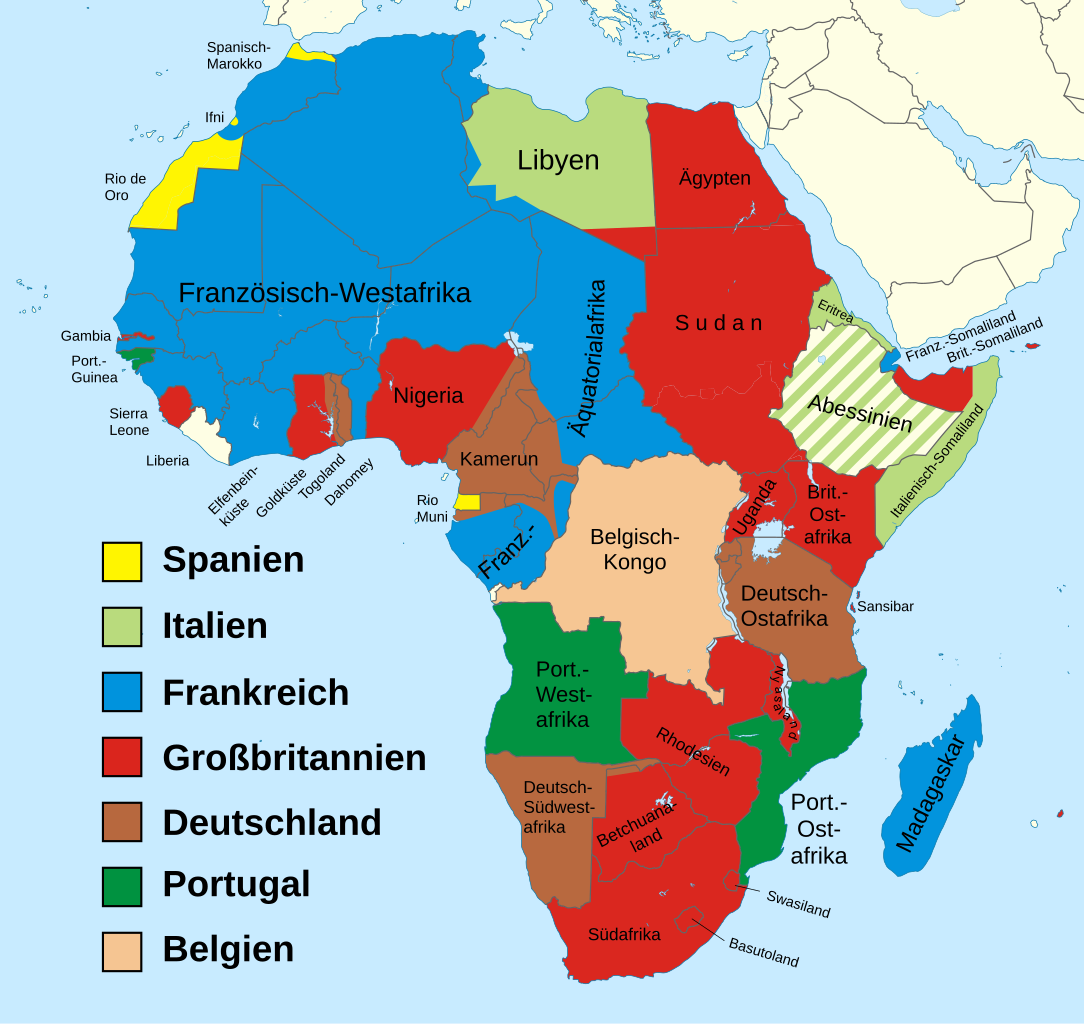
Deutsch: Karte des kolonialen Afrika im Jahr 1914. Español: Mapa del África colonial en el 1914, en alemán. Italiano: Mappa dell'Africa coloniale nel 1914, in tedesco. |
| Date | |
| Source |
Own work (Original caption: " selbst vektorisiert, Vorlage: Bitmap von Benutzer:Tristan-baeu und Africa location map.svg by Eric Gaba (Sting - fr:Sting) ") |
| Author | Frank Murmann (talk · contribs) |
| Other versions |
[]
|
| SVG development |


.svg)

_ast.svg)


-es.svg)
_mapa.png)

_eu.svg)


.svg)

.jpg)


-sr.png)


.svg)

.svg)


|
This derivative work has been modified from the original image by cropping, minor retouching, or other minor changes. These changes are ineligible for copyright and therefore this image remains available under the same terms as the original image. A valid license tag must accompany this tag or the image may be deleted.
|
| I, the copyright holder of this work, release this work into the public domain. This applies worldwide. In some countries this may not be legally possible; if so: I grant anyone the right to use this work for any purpose, without any conditions, unless such conditions are required by law. |
Original upload log[edit]
Transferred from de.wikipedia to Commons by Brackenheim using CommonsHelper.
The original description page was here. All following user names refer to de.wikipedia.
- 2011-09-26 16:51 Frank Murmann 1525×1440 (1010005 bytes) {{Information |Beschreibung = Karte der Kolonialmächte in Afrika |Quelle = selbst vektorisiert, Vorlage: Bitmap von [[Benutzer:Tristan-baeu]] |Urheber = unbekannt |Datum = unbekannt |Genehmigung = {{Bild-frei}} |And
- Minor caption typo fix ("Abbessinien" => "Abessinien") --Kraschnaut 19:35, 11 March 2013 (UTC)
File history
Click on a date/time to view the file as it appeared at that time.
| Date/Time | Thumbnail | Dimensions | User | Comment | |
|---|---|---|---|---|---|
| current | 18:44, 11 March 2013 | | 1,525 × 1,440 (986 KB) | Kraschnaut (talk | contribs) | Beschriftung "Abbessinien" in "Abessinien" berichtigt. |
| 14:36, 2 November 2011 |  | 1,525 × 1,440 (986 KB) | File Upload Bot (Magnus Manske) (talk | contribs) | {{BotMoveToCommons|de.wikipedia|year={{subst:CURRENTYEAR}}|month={{subst:CURRENTMONTHNAME}}|day={{subst:CURRENTDAY}}}} {{Information |Description={{de|Karte der Kolonialmächte in Afrika<br/> de:Kategorie:Datei:Karte de:Kategorie:Datei:Afrika |
You cannot overwrite this file.
File usage on Commons
The following 47 pages use this file:
- File:Africa1913 fr.png
- File:Africa Colonial.png
- File:Africa colonization 1914.PNG
- File:Africacolony.PNG
- File:African colonization map (swedish).jpg
- File:Afrika 1913.png
- File:Afrika 1914.png
- File:Afrika 1914 - sr.png
- File:Afrika Kolonisation Farben.png
- File:Afrika koloniala 1914an.png
- File:ColonialAfrica-da.png
- File:ColonialAfrica-no.png
- File:ColonialAfrica.png
- File:ColonialAfrica Zh.PNG
- File:Colonial Africa 1800 map.png
- File:Colonial Africa 1870 map-fr.png
- File:Colonial Africa 1870 map.png
- File:Colonial Africa 1900 map-fr.png
- File:Colonial Africa 1900 map.png
- File:Colonial Africa 1913, pre WWI-es.svg
- File:Colonial Africa 1913, pre WWI.svg
- File:Colonial Africa 1913 map.svg
- File:Colonial Africa 1914 map-he.png
- File:Colonial Africa 1914 map.png
- File:Colonial Africa 1923 map.png
- File:Colonias en Africa (1914) mapa.png
- File:Colonies in Africa in 1914.jpg
- File:Decolonization of Africa PL.PNG
- File:FeizhouZhimindi.png
- File:Hui-chiu sit-bin-te 1914.png
- File:Kolonie Afryka 1947.PNG
- File:Kolonie afryka 1914.PNG
- File:Kolonien-Afrikas.svg
- File:Kolonisation Afrikas.png
- File:Map of Africa in 1939.png
- File:Map of Colonial Africa (1914)-sr.png
- File:Mapa del África colonial (1914).svg
- File:Mapa del África colonial (1914) ast.svg
- File:Mapa del África colonial (1914) eu.svg
- File:Mapa del África colonial (1939).svg
- File:Mapa del África colonial (1947).svg
- File:Mapa mudo del África colonial (1914).svg
- File:Mapa polityczna Afryki (1914)-es.svg
- File:Mapa polityczna Afryki (1914).svg
- File:ΑποικιακήΑφρική.png
- File:Колонии на Африка през 1914.png
- Template:Other versions/Colonial Africa
.svg)
File usage on other wikis
The following other wikis use this file:
- Usage on als.wikipedia.org
- Usage on de.wikipedia.org
- Usage on eo.wikipedia.org
- Usage on hu.wikipedia.org
- Usage on lb.wikipedia.org
- Usage on rm.wikipedia.org