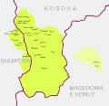
File:Krahina e Gorës – (Gora region).svg

Original file (SVG file, nominally 6,436 × 6,253 pixels, file size: 172 KB)
Captions
Captions
Summary[edit]
| DescriptionKrahina e Gorës – (Gora region).svg |
Shqip: Krahina e Gorës
English: Gora region
Steinke, Klaus (2010) Die slavischen Minderheiten in Albanien (SMA). 3. Gora, Munich: Verlag Otto Sagner, p. 11. ISBN: 978-3-86688-112-9. Schmidinger, Thomas (2013). Gora: Slawischsprachige Muslime zwischen Kosovo, Albanien, Mazedonien und Diaspora. Wiener Verlag. pp. 98-99. ISBN 9783944690049
Schmidinger, Thomas (2013). Gora: Slawischsprachige Muslime zwischen Kosovo, Albanien, Mazedonien und Diaspora. Wiener Verlag. p. 65. ISBN 9783944690049 Schmidinger, Thomas (2018) "Forced return to empty villages: A case study of the Gorani in Kosovo" in Remigration to Post-Socialist Europe. Hopes and Realities of Return, Lit Verlag, p. 265. ISBN: 9783643910257.
Koleva, Krasimira (2012) "Balkanisms today: The dialect of Župa (Kosovo)" in Balkanismen heute – Balkanisms today – Балканизмы сегодня, LIT Verlag, p. 351. ISBN: 9783643503886. Rexhepi, Besnik; Mustafa, Behxhet; Hajdari, Avni; Rushidi-Rexhepi, Jehona; Quave, Cassandra L.; Pieroni, Andrea (2014). "Cross-cultural ethnobotany of the Sharr Mountains (northwestern Macedonia)". In Pieroni, Andrea; Quave, Cassandra L. (eds.). Ethnobotany and Biocultural Diversities in the Balkans. Springer. p. 70. ISBN 9781493914920
|
| Date | |
| Source | Own work |
| Author | Resnjari |
Licensing[edit]
- You are free:
- to share – to copy, distribute and transmit the work
- to remix – to adapt the work
- Under the following conditions:
- attribution – You must give appropriate credit, provide a link to the license, and indicate if changes were made. You may do so in any reasonable manner, but not in any way that suggests the licensor endorses you or your use.
- share alike – If you remix, transform, or build upon the material, you must distribute your contributions under the same or compatible license as the original.
File history
Click on a date/time to view the file as it appeared at that time.
| Date/Time | Thumbnail | Dimensions | User | Comment | |
|---|---|---|---|---|---|
| current | 10:57, 7 September 2020 |  | 6,436 × 6,253 (172 KB) | Resnjari (talk | contribs) | Uploaded own work with UploadWizard |
You cannot overwrite this file.
File usage on Commons
There are no pages that use this file.
File usage on other wikis
The following other wikis use this file:
- Usage on azb.wikipedia.org
- Usage on ba.wikipedia.org
- Usage on cs.wikipedia.org
- Usage on de.wikipedia.org
- Usage on en.wikipedia.org
- Usage on es.wikipedia.org
- Usage on et.wikipedia.org
- Usage on fa.wikipedia.org
- Usage on fi.wikipedia.org
- Usage on fr.wikipedia.org
- Usage on hr.wikipedia.org
- Usage on id.wikipedia.org
- Usage on ko.wikipedia.org
- Usage on myv.wikipedia.org
- Usage on nl.wikipedia.org
- Usage on pl.wikipedia.org
- Usage on pt.wikipedia.org
- Usage on sq.wikipedia.org
- Usage on sv.wikipedia.org
- Usage on tr.wikipedia.org
Metadata
This file contains additional information such as Exif metadata which may have been added by the digital camera, scanner, or software program used to create or digitize it. If the file has been modified from its original state, some details such as the timestamp may not fully reflect those of the original file. The timestamp is only as accurate as the clock in the camera, and it may be completely wrong.
| Width | 6435.5557 |
|---|---|
| Height | 6252.6982 |