File:Längsschnitt westlich der Melachmündung.svg
Jump to navigation
Jump to search

Size of this PNG preview of this SVG file: 570 × 170 pixels. Other resolutions: 320 × 95 pixels | 640 × 191 pixels | 1,024 × 305 pixels | 1,280 × 382 pixels | 2,560 × 764 pixels.
Original file (SVG file, nominally 570 × 170 pixels, file size: 70 KB)
Captions
Captions
Add a one-line explanation of what this file represents
Summary
[edit]
| Description |
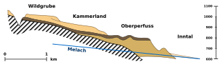
Deutsch: Längsschnitt westlich der Melachmündung, nach Hans Bobek: Geologisches Profil in der Melachschlucht, dem Einschnitt der untersten Melach zum Inntal, Nordtirol, zwischen Oberperfuss und Grinzens nahe Innsbruck, Richtung Nordwesten (Detaillierte Beschreibung siehe unten).
English: Geological cross section of estuary of Melach River, Inn Valley, Tyrol, heading northwest. Following Hans Bobek (detailed description see below). |
| Date |
|
| Source |
Hans Bobek, Die jüngere Geschichte der Inntalterrasse und der Rückzug der letzten Vergletscherang im Inntal, Jahrbuch der Geologischen Bundesanstalt 85, Wien 1935, p. 145, fig. 2, Längsschnitt westlich der Melachmündung (135–189)
|
| Author |
Hans Bobek/Geologische Bundesanstalt
|
| Object location | | View this and other nearby images on: OpenStreetMap |
|---|
This W3C-unspecified vector image was created with Inkscape .
- original font: Bitstream Vera Sans 12 (8, 11) - converted to path
Detailed Description
[edit]
Deutsch: Legende:
- Grundgebirge
- (d3b063) interglaziale Terassensedimente
- (745c40) Hangendmoräne der letzten Vergletscherung
- (f8ce88) spätglaziale Sedimente
- Niveau der Melach
Das Profil zeigt das Terrassenland des Mittelgebirgs um Innsbruck. Bei Oberperfuss sind Riedel einer Toteislandschaft erkennbar.
- Anm.: Wildgrube war ursprünglich „Mairhof“ benannt (heutiger Ortsname: Österreichische Karte); hangend [geol.] „aufliegend“
English: Legend:
- black striped: basement rocks
- d3b063: interglacial sediment terraces
- 745c40: overlying moraine of last glacial epoch
- f8ce88: late glacial sediment
- solid blue line: elevation of Melach river
Licensing
[edit]
This file is licensed under the Creative Commons Attribution 3.0 Unported license.
Attribution: Hans Bobek/Geologische Bundesanstalt (1935)
- You are free:
- to share – to copy, distribute and transmit the work
- to remix – to adapt the work
- Under the following conditions:
- attribution – You must give appropriate credit, provide a link to the license, and indicate if changes were made. You may do so in any reasonable manner, but not in any way that suggests the licensor endorses you or your use.
File history
Click on a date/time to view the file as it appeared at that time.
| Date/Time | Thumbnail | Dimensions | User | Comment | |
|---|---|---|---|---|---|
| current | 10:53, 2 November 2012 | 570 × 170 (70 KB) | W!B: (talk | contribs) | {{Information |Description ={{de|1=xxxxx}} |Source ={{own}} |Author =W!B: |Date =2012 |Permission = |other_versions = }} |
You cannot overwrite this file.
File usage on Commons
There are no pages that use this file.
File usage on other wikis
The following other wikis use this file:
- Usage on de.wikipedia.org