File:LASB K Hellwig 0232.jpg
Jump to navigation
Jump to search

Size of this preview: 773 × 599 pixels. Other resolutions: 310 × 240 pixels | 619 × 480 pixels | 990 × 768 pixels | 1,280 × 993 pixels | 2,560 × 1,985 pixels | 8,124 × 6,300 pixels.
Original file (8,124 × 6,300 pixels, file size: 18.34 MB, MIME type: image/jpeg)
Captions
Captions
Add a one-line explanation of what this file represents
Summary[edit]
| Description |
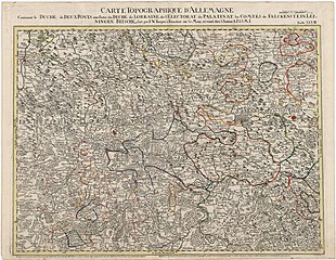
Deutsch: Topographische Deutschlandkarte: Saarregion und angrenzende Gebiete (CARTE TOPOGRAPHIQUE D' ALLEMAGNE Contenant le DUCHÉ de DEUX PONTS, une Partie du DUCHÉ de LORRAINE, de l' ELECTORAT de PALATINAT, les COMTÉS de FALCKENSTEIN, LEININGEN, BITSCHE, fait par I. W. Jaeger à Francfort sur le Mein se vend chez l`Auteur A.P.d.S.M.I.) - Kupferstich in altem Kolorit - französisch - ca. 1:220.000 - 52,9 x 68,1 cm - [1770 - 1776] |
| Date | |
| Source | Landesarchiv Saarbrücken, Kartensammlung Hellwig Nr. 232 |
| Author | Jäger, Johann Wilhelm Abraham (1718 - 1790) |
Licensing[edit]
| Media uploaded by user LandesarchivSaarbrücken are released under CC-BY-SA 3.0 DE. |
This file is licensed under the Creative Commons Attribution-Share Alike 3.0 Germany license. Attribution: Landesarchiv Saarbrücken, Bestand K Hellwig, Nr. 0232, Urheber Johann Wilhelm Abraham Jäger (1718-1790) / CC-BY-SA 3.0 DE
 |
File history
Click on a date/time to view the file as it appeared at that time.
| Date/Time | Thumbnail | Dimensions | User | Comment | |
|---|---|---|---|---|---|
| current | 08:21, 11 May 2021 | | 8,124 × 6,300 (18.34 MB) | LandesarchivSaarbrücken (talk | contribs) | Uploaded a work by Jäger, Johann Wilhelm Abraham (1718 - 1790) from Landesarchiv Saarbrücken, Kartensammlung Hellwig Nr. 232 with UploadWizard |
You cannot overwrite this file.
File usage on Commons
There are no pages that use this file.