File:Landkreis Cham Karte.svg
Jump to navigation
Jump to search

Size of this PNG preview of this SVG file: 543 × 447 pixels. Other resolutions: 292 × 240 pixels | 583 × 480 pixels | 933 × 768 pixels | 1,244 × 1,024 pixels | 2,488 × 2,048 pixels.
Original file (SVG file, nominally 543 × 447 pixels, file size: 528 KB)
Captions
Captions
Add a one-line explanation of what this file represents
Summary[edit]
| Description |
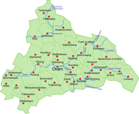
Deutsch: Karte des Landkreises Cham mit Gemeinden, Flüßen und Grenzen |
| Date | |
| Source |
Own work Deutsch: selbsterstellt mit Inkscape |
| Author | Bonilla at German Wikipedia |
Licensing[edit]
| This work has been released into the public domain by its author, Bonilla at German Wikipedia. This applies worldwide. In some countries this may not be legally possible; if so: Bonilla grants anyone the right to use this work for any purpose, without any conditions, unless such conditions are required by law. |
Original upload log[edit]
Transferred from de.wikipedia to Commons by Heubergen using CommonsHelper.
The original description page was here. All following user names refer to de.wikipedia.
- 2009-06-10 23:19 Bonilla 543×447× (540237 bytes) {{Information |Beschreibung = Karte des Landkreises Cham mit Gemeinden, Flüßen und Grenzen |Quelle = |Urheber = Bonilla |Datum = 11.06.2009 |Genehmigung = |Andere Versionen = |Anmerkungen = Grenzen und Verläufe sind nur annäherungsweise korrekt }}
File history
Click on a date/time to view the file as it appeared at that time.
| Date/Time | Thumbnail | Dimensions | User | Comment | |
|---|---|---|---|---|---|
| current | 20:24, 29 May 2013 | | 543 × 447 (528 KB) | File Upload Bot (Magnus Manske) (talk | contribs) | Transfered from de.wikipedia by User:heubergen using CommonsHelper |
You cannot overwrite this file.
File usage on Commons
The following page uses this file:
File usage on other wikis
The following other wikis use this file:
- Usage on de.wikipedia.org