File:Landsat Data Continuity Mission Operational Land Imager Instrument Design.jpg
Jump to navigation
Jump to search

Size of this preview: 800 × 595 pixels. Other resolutions: 320 × 238 pixels | 640 × 476 pixels | 1,024 × 762 pixels | 1,280 × 952 pixels | 2,560 × 1,904 pixels | 5,620 × 4,180 pixels.
Original file (5,620 × 4,180 pixels, file size: 904 KB, MIME type: image/jpeg)
Captions
Captions
Add a one-line explanation of what this file represents
Summary[edit]
| Description |
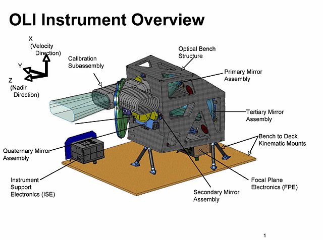
English: The Operational Land Imager (OLI) was built by the Ball Aerospace and Technologies Corporation. The Ball contract was awarded in July 2007. OLI improves on past Landsat sensors using a technical approach demonstrated by a sensor flown on NASA's experimental EO-1 satellite. OLI is a push-broom sensor with a four-mirror telescope and 12-bit quantization. OLI will collect data for visible, near infrared, and short wave infrared spectral bands as well as a panchromatic band. It has a five-year design life. |
| Source | http://landsat.gsfc.nasa.gov/about/ldcm.html |
| Author | NASA |
Licensing[edit]
| This file is in the public domain in the United States because it was solely created by NASA. NASA copyright policy states that "NASA material is not protected by copyright unless noted". (See Template:PD-USGov, NASA copyright policy page or JPL Image Use Policy.) | ||
 |
Warnings:
|
File history
Click on a date/time to view the file as it appeared at that time.
| Date/Time | Thumbnail | Dimensions | User | Comment | |
|---|---|---|---|---|---|
| current | 17:37, 12 February 2013 | | 5,620 × 4,180 (904 KB) | Joseph.gruber (talk | contribs) | {{subst:Upload marker added by en.wp UW}} {{Information |Description = {{en|The Operational Land Imager (OLI) was built by the Ball Aerospace and Technologies Corporation. The Ball contract was awarded in July 2007. OLI improves on past Landsat sensors... |
You cannot overwrite this file.
File usage on Commons
There are no pages that use this file.
File usage on other wikis
The following other wikis use this file:
- Usage on en.wikipedia.org
- Usage on fa.wikipedia.org
- Usage on ru.wikipedia.org