File:Laptev Sea map - Morze Łaptiewów polish version-pl.png
Jump to navigation
Jump to search

Size of this preview: 800 × 449 pixels. Other resolutions: 320 × 179 pixels | 640 × 359 pixels | 1,024 × 574 pixels | 1,500 × 841 pixels.
Original file (1,500 × 841 pixels, file size: 492 KB, MIME type: image/png)
Captions
Captions
Add a one-line explanation of what this file represents
| Description |
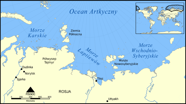
English: This map shows the location of the Laptev Sea north of Siberia, Russia. The sea is part of the Arctic Ocean, and neighbours the Kara Sea and East Siberian Sea. Created by NormanEinstein, December 5, 2005. / Modified by Vearthy, March 28, 2009.
Polski: Mapa wskazuje lokalizację Morza Łaptiewów, Morza Karskiego oraz Morza Wschodniosyberyjskiego, części Oceanu Arktycznego. Stworzone przez NormanEinstein, 5 grudnia, 2005. / Przetłumaczone, poprawione przez Vearthy, 28 marca, 2009. |
| Date | (UTC) |
| Source | |
| Author |
|
| Other versions |
File:Laptev Sea map.png File:Laptev Sea map-fr.svg File:Laptev Sea map-el.svg |
| This is a retouched picture, which means that it has been digitally altered from its original version. Modifications: translated into polish (przetłumaczyłem na język polski). The original can be viewed here: Laptev Sea map.png:
|
I, the copyright holder of this work, hereby publish it under the following license:

|
Permission is granted to copy, distribute and/or modify this document under the terms of the GNU Free Documentation License, Version 1.2 or any later version published by the Free Software Foundation; with no Invariant Sections, no Front-Cover Texts, and no Back-Cover Texts. A copy of the license is included in the section entitled GNU Free Documentation License. |
| This file is licensed under the Creative Commons Attribution-Share Alike 3.0 Unported license. | ||
| ||
| This licensing tag was added to this file as part of the GFDL licensing update. |
Original upload log[edit]
This image is a derivative work of the following images:
- File:Laptev_Sea_map.png licensed with GFDL
- 2005-12-05T21:42:01Z NormanEinstein 1500x841 (597176 Bytes) This map shows the location of the Laptev Sea north of Siberia, Russia. The sea is part of the Arctic Ocean, and neighbours the Kara Sea and East Siberian Sea. Created by NormanEinstein, December 5, 2005. {{GFDL-self}} [[C
Uploaded with derivativeFX
File history
Click on a date/time to view the file as it appeared at that time.
| Date/Time | Thumbnail | Dimensions | User | Comment | |
|---|---|---|---|---|---|
| current | 23:15, 27 March 2009 | | 1,500 × 841 (492 KB) | Vearthy (talk | contribs) | {{Information |Description={{en|This map shows the location of the Laptev Sea north of Siberia, Russia. The sea is part of the Arctic Ocean, and neighbours the Kara Sea and East Siberian Sea. Created by NormanEinstein, December 5, 2005. / Modified by Vea |
You cannot overwrite this file.
File usage on Commons
There are no pages that use this file.