File:Lawrence Hill North express geograph-2920188-by-Ben-Brooksbank.jpg
Jump to navigation
Jump to search
Size of this preview: 800 × 470 pixels. Other resolutions: 320 × 188 pixels | 640 × 376 pixels | 1,024 × 602 pixels | 1,280 × 752 pixels | 2,394 × 1,407 pixels.
Original file (2,394 × 1,407 pixels, file size: 1.38 MB, MIME type: image/jpeg)
Captions
Captions
Add a one-line explanation of what this file represents
Summary
[edit]
| Description |
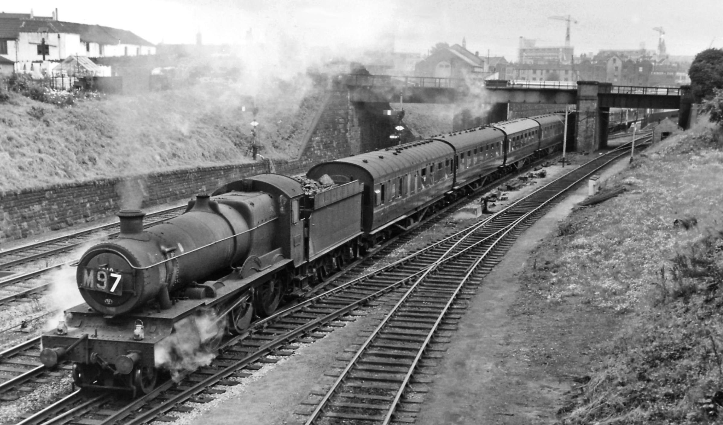
English: West-to-North express struggling up out of Bristol through Lawrence Hill. View southward, towards Lawrence Hill, Dr Day's Bridge Junction, Bristol etc.: ex-GWR main lines west-, north- and eastwards from Bristol, through Stapleton Road and up to Filton Junction. (The ex-Midland line out towards Mangotsfield, Gloucester and the North, also Bath, is on the bridge above the train. The Summer Saturday 12.00 Kingswear - Manchester Piccadilly is headed by Collett 4-6-0 No. 6810 'Blakemere Grange' (built 11/36, withdrawn 10/64): it will run via the Severn Tunnel, Pontypool Road, Hereford to Shrewsbury, where an LMR engine will take over and run via Crewe. |
| Date | |
| Source | From geograph.org.uk |
| Author | Ben Brooksbank |
| Permission (Reusing this file) |
Creative Commons Attribution Share-alike license 2.0 |
| Attribution (required by the license) | Ben Brooksbank / West-to-North express struggling up out of Bristol through Lawrence Hill / |
| Camera location | | View this and other nearby images on: OpenStreetMap |
|---|
Licensing
[edit]

|
This image was taken from the Geograph project collection. See this photograph's page on the Geograph website for the photographer's contact details. The copyright on this image is owned by Ben Brooksbank and is licensed for reuse under the Creative Commons Attribution-ShareAlike 2.0 license.
|
This file is licensed under the Creative Commons Attribution-Share Alike 2.0 Generic license.
Attribution: Ben Brooksbank
- You are free:
- to share – to copy, distribute and transmit the work
- to remix – to adapt the work
- Under the following conditions:
- attribution – You must give appropriate credit, provide a link to the license, and indicate if changes were made. You may do so in any reasonable manner, but not in any way that suggests the licensor endorses you or your use.
- share alike – If you remix, transform, or build upon the material, you must distribute your contributions under the same or compatible license as the original.
File history
Click on a date/time to view the file as it appeared at that time.
| Date/Time | Thumbnail | Dimensions | User | Comment | |
|---|---|---|---|---|---|
| current | 13:17, 5 May 2012 | | 2,394 × 1,407 (1.38 MB) | Chevin (talk | contribs) | == {{int:filedesc}} == {{Information |Description={{en|1='''West-to-North express struggling up out of Bristol through Lawrence Hill.'''<br/> View southward, towards Lawrence Hill, Dr Day's Bridge Junction, Bristol etc.: ex-GWR main lines west-, north-... |
You cannot overwrite this file.
File usage on Commons
There are no pages that use this file.