File:Legend for Franciscan Cadastral Maps 1824.jpg
Jump to navigation
Jump to search

Size of this preview: 796 × 600 pixels. Other resolutions: 319 × 240 pixels | 637 × 480 pixels | 1,020 × 768 pixels | 1,280 × 964 pixels | 2,560 × 1,929 pixels | 5,409 × 4,075 pixels.
Original file (5,409 × 4,075 pixels, file size: 3.52 MB, MIME type: image/jpeg)
Captions
Captions
Add a one-line explanation of what this file represents
Summary[edit]
| Description |
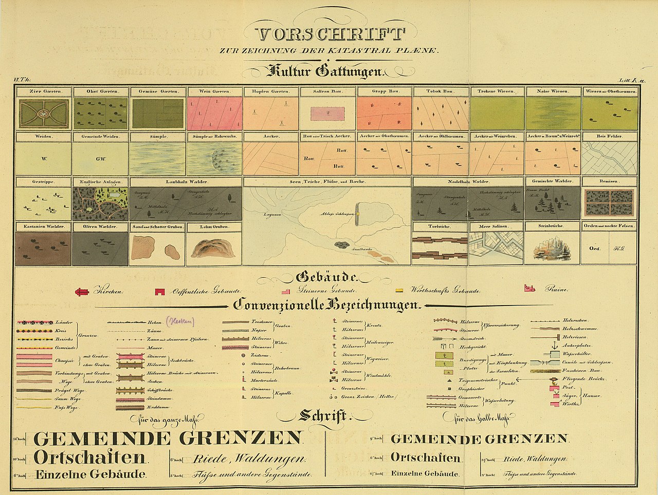
English: Legend for the maps of the Franciscan Cadastral Maps of the Austro-Hungarian Empire Deutsch: Legende zu den Kartenblättern des Franziszeischen Katasters |
| Date | |
| Source | http://www.bev.gv.at/pls/portal/docs/PAGE/BEV_PORTAL_CONTENT_ALLGEMEIN/0200_PRODUKTE/PDF/ZEICHENERKLAERUNG_VON_1824_FUER_DEN_HISTORISCHEN_KATASTER_URMAPPE.PDF |
| Author | Survey Office of the Austro-Hungarian Empire |
| Other versions |
|

.jpg)
Licensing[edit]
|
This work is in the public domain in its country of origin and other countries and areas where the copyright term is the author's life plus 70 years or fewer. This work is in the public domain in the United States because it was published (or registered with the U.S. Copyright Office) before January 1, 1929. | |
| This file has been identified as being free of known restrictions under copyright law, including all related and neighboring rights. | |
File history
Click on a date/time to view the file as it appeared at that time.
| Date/Time | Thumbnail | Dimensions | User | Comment | |
|---|---|---|---|---|---|
| current | 18:33, 14 December 2014 | | 5,409 × 4,075 (3.52 MB) | Torana (talk | contribs) | higher resolution, extracted fom PDF |
| 14:14, 14 December 2014 |  | 1,890 × 1,425 (3.48 MB) | Enzoklop (talk | contribs) | User created page with UploadWizard |
You cannot overwrite this file.
File usage on Commons
The following 2 pages use this file:
File usage on other wikis
The following other wikis use this file:
- Usage on cs.wikipedia.org
- Usage on de.wikipedia.org