File:Lehrte-borken-abbau.jpg
Original file (4,608 × 3,456 pixels, file size: 5.15 MB, MIME type: image/jpeg)
Captions
Summary[edit]
DescriptionLehrte-borken-abbau.jpg |
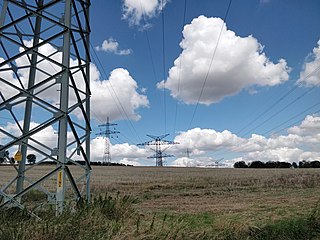
English: Temporary wiring of old Lehrte-Borken line due to replacement |
|||||||||
Date | ||||||||||
Source | Own work | |||||||||
Author | Kreuzschnabel | |||||||||
Permission (Reusing this file) |
I, the copyright holder of this work, hereby publish it under the following license: This file is licensed under the Creative Commons Attribution-Share Alike 3.0 Unported license.
|
Camera location | 51° 42′ 04.07″ N, 9° 54′ 36.22″ E | View this and other nearby images on: OpenStreetMap | 51.701130; 9.910060 |
---|
File history
Click on a date/time to view the file as it appeared at that time.
Date/Time | Thumbnail | Dimensions | User | Comment | |
---|---|---|---|---|---|
current | 16:55, 4 August 2020 | 4,608 × 3,456 (5.15 MB) | Kreuzschnabel (talk | contribs) | bright | |
16:54, 4 August 2020 | 4,608 × 3,456 (4.61 MB) | Kreuzschnabel (talk | contribs) | {{Information |description ={{en|1=Temporary wiring of old Lehrte-Borken line due to replacement}} |date =2020-08-04 |source ={{own}} |author =User:Kreuzschnabel |permission ={{subst:User:Kreuzschnabel/Lizenz}} }} {{Location|51.70113|9.91006}} Category:Power lines in Germany |
You cannot overwrite this file.
File usage on Commons
The following page uses this file:
File usage on other wikis
The following other wikis use this file:
- Usage on de.wikipedia.org
Metadata
This file contains additional information such as Exif metadata which may have been added by the digital camera, scanner, or software program used to create or digitize it. If the file has been modified from its original state, some details such as the timestamp may not fully reflect those of the original file. The timestamp is only as accurate as the clock in the camera, and it may be completely wrong.
Camera manufacturer | OnePlus |
---|---|
Camera model | ONEPLUS A5010 |
Exposure time | 1/3,384 sec (0.00029550827423168) |
F-number | f/1.7 |
ISO speed rating | 125 |
Date and time of data generation | 13:50, 4 August 2020 |
Lens focal length | 0 mm |
Latitude | 51° 42′ 4.13″ N |
Longitude | 9° 54′ 36.1″ E |
Altitude | 208.148 meters above sea level |
Orientation | Normal |
Horizontal resolution | 72 dpi |
Vertical resolution | 72 dpi |
Software used | GIMP 2.10.8 |
File change date and time | 18:55, 4 August 2020 |
Y and C positioning | Centered |
Exposure Program | Not defined |
Exif version | 0 |
Date and time of digitizing | 13:50, 4 August 2020 |
Meaning of each component |
|
APEX shutter speed | 11.724 |
APEX aperture | 1.53 |
APEX brightness | 8.24 |
Metering mode | Center weighted average |
Light source | Unknown |
Flash | Flash did not fire, compulsory flash suppression |
DateTime subseconds | 538407 |
DateTimeOriginal subseconds | 538407 |
DateTimeDigitized subseconds | 538407 |
Supported Flashpix version | 1 |
Color space | sRGB |
Sensing method | 0 |
Scene type | A directly photographed image |
Exposure mode | Auto exposure |
White balance | Auto white balance |
Focal length in 35 mm film | 0 mm |
Scene capture type | Standard |
GPS time (atomic clock) | 11:50 |
GPS date | 4 August 2020 |
Unique ID of original document | xmp.did:ff1cb8a6-b22c-471b-b2a1-fa20357b9bc4 |